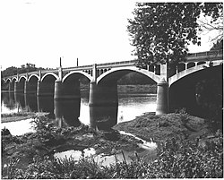
Watsontown River Bridge | |
 Watsontown River Bridge, 1982 | |
| Location | Legislative Route 240 spur over the West Branch of the Susquehanna River, Watsontown and White Deer Township, Pennsylvania |
|---|---|
| Coordinates | 41°4′51″N 76°51′55″W / 41.08083°N 76.86528°W |
| Area | 1 acre (0.40 ha) |
| Built | 1927 |
| Built by | George W. Rockwell |
| Architect | James B. Long |
| Architectural style | Open-spandrel arch |
| MPS | Highway Bridges Owned by the Commonwealth of Pennsylvania, Department of Transportation TR |
| NRHP reference No. | 88000801 [1] |
| Added to NRHP | June 22, 1988 |
Watsontown River Bridge is a historic bridge in Watsontown, Northumberland County, Pennsylvania and White Deer Township, Union County, Pennsylvania. It was built in 1927, and consists of nine open spandrel arches with a total length of 1,080-foot-long (330 m). It is constructed of concrete and crosses the Susquehanna River. [2]
It was listed on the National Register of Historic Places in 1988. [1]
References
- ^ a b "National Register Information System". National Register of Historic Places. National Park Service. July 9, 2010.
- ^ "National Historic Landmarks & National Register of Historic Places in Pennsylvania". CRGIS: Cultural Resources Geographic Information System. Archived from the original (Searchable database) on July 21, 2007. Retrieved May 29, 2012. Note: This includes unknown (n.d.). "National Register of Historic Places Inventory Nomination Form: Watsontown River Bridge" (PDF). Retrieved May 29, 2012.
Categories:
- Bridges completed in 1927
- Road bridges on the National Register of Historic Places in Pennsylvania
- Bridges in Union County, Pennsylvania
- Bridges in Northumberland County, Pennsylvania
- National Register of Historic Places in Northumberland County, Pennsylvania
- National Register of Historic Places in Union County, Pennsylvania
- Concrete bridges in the United States
- Open-spandrel deck arch bridges in the United States
- Pennsylvania Registered Historic Place stubs
- Pennsylvania bridge (structure) stubs


