(Redirected from
Washington Column (Yosemite))
| Washington Column | |
|---|---|
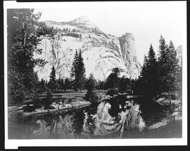 Reflection of trees and Washington Column in lake. North Dome is above, left of Washington Column | |
| Highest point | |
| Elevation | 6,347 ft (1,935 m) NAVD 88 [1] |
| Coordinates | 37°45′00″N 119°33′36″W / 37.75000°N 119.56°W [2] |
| Geography | |
| Location | Yosemite National Park, Mariposa County, California, U.S. |
| Parent range | Sierra Nevada |
| Topo map | USGS Washington Column |
| Geology | |
| Age of rock | Cretaceous |
| Mountain type | Granite dome |
| Climbing | |
| Easiest route | Trail hike from the north, class 1 [3] |
Washington Column is a roughly 1800-foot high rock formation, arising from Yosemite Valley. It is east of the Royal Arches, behind the Ahwahnee Hotel. North Dome is above it. Washington Column can be viewed from many points in Yosemite Valley, [4] including the trail to Mirror Lake. [5]
Washington Column has numerous rock climbing routes. [4]
References
- ^ "Washington Column, California". SummitPost.org.
- ^ "North Dome". Geographic Names Information System. United States Geological Survey, United States Department of the Interior.
- ^ Roper, Steve (1976). The Climber's Guide to the High Sierra. San Francisco: Sierra Club Books. p. 239. ISBN 978-0871561473.
- ^ a b Peer, Craig. "Washington Column - Yosemite Valley".
- ^ "Yosemite national Park California".
External links and references
|
| This Yosemite-related article is a stub. You can help Wikipedia by expanding it. |