Wall Street | |||||||||||||||||||||||||||||||||||||||||||||||||||||||||||||||||||||||||||||||||||||||||
|---|---|---|---|---|---|---|---|---|---|---|---|---|---|---|---|---|---|---|---|---|---|---|---|---|---|---|---|---|---|---|---|---|---|---|---|---|---|---|---|---|---|---|---|---|---|---|---|---|---|---|---|---|---|---|---|---|---|---|---|---|---|---|---|---|---|---|---|---|---|---|---|---|---|---|---|---|---|---|---|---|---|---|---|---|---|---|---|---|---|
|
| |||||||||||||||||||||||||||||||||||||||||||||||||||||||||||||||||||||||||||||||||||||||||
 Platform view | |||||||||||||||||||||||||||||||||||||||||||||||||||||||||||||||||||||||||||||||||||||||||
| Station statistics | |||||||||||||||||||||||||||||||||||||||||||||||||||||||||||||||||||||||||||||||||||||||||
| Address | Wall Street & William Street New York, NY 10005 | ||||||||||||||||||||||||||||||||||||||||||||||||||||||||||||||||||||||||||||||||||||||||
| Borough | Manhattan | ||||||||||||||||||||||||||||||||||||||||||||||||||||||||||||||||||||||||||||||||||||||||
| Locale | Financial District | ||||||||||||||||||||||||||||||||||||||||||||||||||||||||||||||||||||||||||||||||||||||||
| Coordinates | 40°42′23″N 74°00′34″W / 40.706311°N 74.009528°W | ||||||||||||||||||||||||||||||||||||||||||||||||||||||||||||||||||||||||||||||||||||||||
| Division | A ( IRT) [1] | ||||||||||||||||||||||||||||||||||||||||||||||||||||||||||||||||||||||||||||||||||||||||
| Line | IRT Broadway–Seventh Avenue Line | ||||||||||||||||||||||||||||||||||||||||||||||||||||||||||||||||||||||||||||||||||||||||
| Services |
2
3 | ||||||||||||||||||||||||||||||||||||||||||||||||||||||||||||||||||||||||||||||||||||||||
| Transit | MTA Bus: BM1, BM2, BM3, BM4, QM7, QM8, QM11, QM25 | ||||||||||||||||||||||||||||||||||||||||||||||||||||||||||||||||||||||||||||||||||||||||
| Structure | Underground | ||||||||||||||||||||||||||||||||||||||||||||||||||||||||||||||||||||||||||||||||||||||||
| Platforms | 1 island platform | ||||||||||||||||||||||||||||||||||||||||||||||||||||||||||||||||||||||||||||||||||||||||
| Tracks | 2 | ||||||||||||||||||||||||||||||||||||||||||||||||||||||||||||||||||||||||||||||||||||||||
| Other information | |||||||||||||||||||||||||||||||||||||||||||||||||||||||||||||||||||||||||||||||||||||||||
| Opened | July 1, 1918 | ||||||||||||||||||||||||||||||||||||||||||||||||||||||||||||||||||||||||||||||||||||||||
| Opposite- direction transfer | Yes | ||||||||||||||||||||||||||||||||||||||||||||||||||||||||||||||||||||||||||||||||||||||||
| Traffic | |||||||||||||||||||||||||||||||||||||||||||||||||||||||||||||||||||||||||||||||||||||||||
| 2022 | 3,065,803
[3] | ||||||||||||||||||||||||||||||||||||||||||||||||||||||||||||||||||||||||||||||||||||||||
| Rank | 90 out of 423 [3] | ||||||||||||||||||||||||||||||||||||||||||||||||||||||||||||||||||||||||||||||||||||||||
| |||||||||||||||||||||||||||||||||||||||||||||||||||||||||||||||||||||||||||||||||||||||||
| |||||||||||||||||||||||||||||||||||||||||||||||||||||||||||||||||||||||||||||||||||||||||
| |||||||||||||||||||||||||||||||||||||||||||||||||||||||||||||||||||||||||||||||||||||||||
| |||||||||||||||||||||||||||||||||||||||||||||||||||||||||||||||||||||||||||||||||||||||||
| |||||||||||||||||||||||||||||||||||||||||||||||||||||||||||||||||||||||||||||||||||||||||


The Wall Street station is a station on the IRT Broadway–Seventh Avenue Line of the New York City Subway, located at the intersection of Wall Street and William Street in the Financial District of Manhattan. It is served by the 2 train at all times and the 3 train at all times except late nights.
History
Construction and opening

After the original IRT opened, the city began planning new lines. In April 1912, the New York Public Service Commission gave the Brooklyn Rapid Transit Company (BRT) the right to operate the proposed Clark Street Tunnel under the East River, between Old Slip in Lower Manhattan and Clark Street in Downtown Brooklyn. [4] [5] The next month, the Old Slip–Clark Street route was assigned to the IRT instead; the plans called for a station at Fulton Street. [6] [7] The BRT was allowed to extend its Centre Street Line south to a new Montague Street Tunnel. Both this extension and the IRT's Clark Street Tunnel were to have stations at Fulton Street in Lower Manhattan. [8] These routes were finalized in the Dual Contracts between the government of New York City, the BRT, and the IRT, which were signed in 1913. [9]
As part of the Dual Contracts, the New York City Public Service Commission planned to split the original IRT system into three segments: two north-south lines, carrying through trains over the Lexington Avenue and Broadway–Seventh Avenue Lines, and a west-east shuttle under 42nd Street. This would form a roughly H-shaped system. [9] The Dual Contracts entailed building the IRT Broadway–Seventh Avenue Line south of Times Square–42nd Street. [10] [11] South of the Chambers Street station, the line was to split into two branches, one of which would travel under Park Place and William Street to the Clark Street Tunnel in Brooklyn. The Brooklyn branch was to have a station at William and Fulton Streets. [12] Before the Dual Contracts were signed, many business owners on William Street had opposed the construction of a subway line there, claiming that the subway's construction could damage buildings [13] because the street only measured 40 feet (12 m) wide. [14] [15] The New York Supreme Court, Appellate Division, approved the William Street subway in February 1913. [16] [17] The William Street subway was to be a two-track line; the Public Service Commission originally planned to place one track above the other but, by July 1914, had decided to build both tracks on one level. [18] The tunnel was to measure 29 feet (8.8 m) wide, except the stations on Fulton Street and Wall Street, which were to measure 40 feet (12 m) wide. [15]
The Public Service Commission began soliciting bids for the William Street portion of the line in September 1914. [19] [20] Smith, Hauser, & McIsaac submitted a low bid of $2.254 million. [20] The awarding of the contract was delayed by a dispute over whether gas mains should be carried on temporary overpasses above the tunnel's excavation site. [21] [22] Prior to the start of construction, the city government agreed to pay for any damage caused by the project. [23] The contractors underpinned every building along the tunnel because most of the buildings had shallow foundations that extended only to a shallow layer of quicksand, rather than to the bedrock below. [14] [15]
The line was nearly completed by late 1917, but the signals and station finishes were incomplete due to World War I–related material shortages. [24] [25] The Broadway–Seventh Avenue Line's Wall Street station opened on July 1, 1918, and was initially served by a shuttle to and from Chambers Street. [26] On August 1, 1918, the new "H" system was implemented, joining the two halves of the Broadway–Seventh Avenue Line and sending all West Side trains south from Times Square; through trains on the Brooklyn branch began operating to Upper Manhattan and the Bronx. [27] [28] The Wall Street station was the line's terminus until April 15, 1919, when the Clark Street Tunnel opened, allowing service to run to Brooklyn. [29] [30] The connection eased congestion in the Joralemon Street Tunnel, [31] which, prior to the Clark Street Tunnel's opening, was the only tunnel carrying IRT trains between Manhattan and Brooklyn. [32]
Later years
The IRT had installed silencing devices on the station's turnstiles by early 1931. [33] [34] The city government took over the IRT's operations on June 12, 1940. [35] [36] During the 1964–1965 fiscal year, the platforms at Wall Street, along with those at four other stations on the Broadway–Seventh Avenue Line, were lengthened to 525 feet to accommodate a ten-car train of 51-foot IRT cars. [37]
In the 1980s, as part of the construction of the nearby 60 Wall Street, an entrance to the Wall Street station was constructed in that building's lobby. [38] In 1995, as a result of service reductions, the MTA was considering permanently closing one of the two Wall Street stations, as well as two other stations citywide, due to their proximity to each other. Either the IRT Broadway–Seventh Avenue Line station or the IRT Lexington Avenue Line station would have been closed. [39]
Station layout
| Ground | Street level | Exit/entrance |
| Mezzanine | Fare control, station agent | |
| Platform level | Northbound | ←
← |
| Island platform | ||
| Southbound |
→ | |
The Wall Street station is under the intersection of Wall and William Streets.The 2 train serves the station at all times, [40] while the 3 train stops here at all times except late nights. [41] The station is the southernmost in Manhattan on the Brooklyn Branch of the Broadway–Seventh Avenue Line. [42] South of here, the line travels under the East River via the Clark Street Tunnel to Brooklyn Heights. The station is between Fulton Street to the north and Clark Street in Brooklyn to the south. [43]
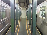
The single island platform is between the two tracks, and is very narrow compared to other stations in system. It has blue I-beam columns and dark blue floors tiles. The walls by the tracks have small "W" tablets on a mosaic trim except at the north end, where they have "WALL ST" written in black letters on white tablets over a green trim line. This is where the platform was extended in 1964–1965. [37] The platform also has cooling fans. [44]
There is a narrow full-length mezzanine above the platform that has mosaics pointing to, and connecting, all four station entrances.
Exits

This station has four sets of entrances/exits. The first exit is at the northern end of the station. It has a customer assistance booth with a bank of turnstiles and long passageway to a set of doors leading to the basement of 28 Liberty Street. A wide staircase leads to an entrance/exit at the east side of Nassau Street at Cedar Street. This entrance is only open on weekdays and also provides access to the Broad Street station ( J and Z trains) and the Wall Street/Broadway station ( 4 and 5 trains). [45]
The second exit, also open weekdays only, contains a bank of turnstiles and passageway to a spiral staircase that leads to Pine Street outside 60 Wall Street. The passageway has an artwork called Subway Wall by Harry Roseman made in 1990 and installed after a 1993 station renovation. This exit also has a set of doors to two escalators and a double-wide staircase that go up to the public atrium lobby of 60 Wall Street. This entrance has two red globes and overhead signs, giving the impression of an outdoor station entrance built in the lobby. [45]
The third exit was the original entrance to the station and is staffed full-time. It has a bank of turnstiles and staircases to both northern corners of William and Wall Streets. [45] The entrance at the northeast corner, outside 48 Wall Street, is made of ornate metal and has a sign reading "Interborough Rapid Transit Co-to All Trains."
The last exit is at the south end of the station, which leads to the same intersection as the third exit but is in a separate fare control area. A single double-wide staircase from the platform leads to two HEET turnstiles and two regular turnstiles. Staircases lead to both southern corners of William and Wall Streets; the southeastern corner exit is outside 55 Wall Street. This exit, though open at all times, is unstaffed as there is no token booth. [45]
A fifth exit, which led to the southwestern corner of Pine Street and William Street, [46] [47] was closed after April 1992. [48] An exit to the northeast corner of the same intersection was removed and slabbed over in 1948. [49] The northeast-corner exit had been closed by 1944. [50] [51] Exits also existed to the northwest and southeast corners of the same intersection until some point after 1944.[ citation needed]
Lower Manhattan transit | ||||||||||||||||||||||||||||||||||||||||||||||||||||||||||||||||||||||||||||||||||||||||||||||||||
|---|---|---|---|---|---|---|---|---|---|---|---|---|---|---|---|---|---|---|---|---|---|---|---|---|---|---|---|---|---|---|---|---|---|---|---|---|---|---|---|---|---|---|---|---|---|---|---|---|---|---|---|---|---|---|---|---|---|---|---|---|---|---|---|---|---|---|---|---|---|---|---|---|---|---|---|---|---|---|---|---|---|---|---|---|---|---|---|---|---|---|---|---|---|---|---|---|---|---|
|
| ||||||||||||||||||||||||||||||||||||||||||||||||||||||||||||||||||||||||||||||||||||||||||||||||||
Image gallery
-
 Entrance/Exit from Wall Street
 -
 Old IRT sign at an entrance
 -
 The platform viewed from the extremely narrow north end
 -
 Mezzanine above the platforms
 -
 Entrance from 28 Liberty Street
 -
 Part-time entrance from the lobby of 60 Wall Street


References
- ^ "Glossary". Second Avenue Subway Supplemental Draft Environmental Impact Statement (SDEIS) (PDF). Vol. 1. Metropolitan Transportation Authority. March 4, 2003. pp. 1–2. Archived from the original (PDF) on February 26, 2021. Retrieved January 1, 2021.
- ^ "Annual Subway Ridership (2017–2022)". Metropolitan Transportation Authority. 2022. Retrieved November 8, 2023.
- ^ a b "Annual Subway Ridership (2017–2022)". Metropolitan Transportation Authority. 2022. Retrieved November 8, 2023.
- ^ "Fix Tunnel Routes for New Subways; One for B.R.T. Across Broadway, Through Beaver to Old Slip, and Under River". The New York Times. April 27, 1912. ISSN 0362-4331. Retrieved May 5, 2023.
- ^ "Lay Out New Subway: P. S. C. Gives B. R. T. Tunnel From Old Slip to Clark Street Sent to Estimate Board Work on Lexington Avenue Line, Below 41st Street, Ordered Suspended for a Time". New-York Tribune. April 27, 1912. p. 6. ISSN 1941-0646. ProQuest 574907612.
- ^ "Dual Subway Routes Fixed; Service Commission and McAneny Committee Agree, Satisfying Interboro and B.R.T." The New York Times. May 15, 1912. ISSN 0362-4331. Retrieved May 6, 2023.
- ^ "Subway Agreement Finally Reached: Both Interborough and B. R. T. Said to Be Satisfied With Conferrees' Solution of Problem". New-York Tribune. May 15, 1912. p. 1. ISSN 1941-0646. ProQuest 97294038.
- ^ "Pick Out Stations for Dual Subway; Sept. 12 and 13 Set for Public Hearings on Locations Favored by Service Board". The New York Times. August 15, 1912. ISSN 0362-4331. Retrieved May 6, 2023.
- ^ a b "Money Set Aside for New Subways; Board of Estimate Approves City Contracts to be Signed To-day with Interboro and B.R.T." (PDF). The New York Times. March 19, 1913. ISSN 0362-4331. Archived (PDF) from the original on July 7, 2021. Retrieved November 10, 2017.
- ^ "Three New Links of the Dual Subway System Opened, Including a Shuttle Service from Times Square to Thirty-Fourth Street — Service on the Jerome Avenue Branch From 149th Street North to About 225th Street Began Yesterday Afternoon — The Event Celebrated by Bronx Citizens and Property Owners — The Seventh Avenue Connection Opened This Morning" (PDF). The New York Times. June 3, 1917. p. 1. ISSN 0362-4331. Archived (PDF) from the original on July 7, 2021. Retrieved November 6, 2016.
- ^ "Annual report. 1916-1917". HathiTrust. Interborough Rapid Transit Company. December 12, 2013. p. 22. Archived from the original on March 18, 2020. Retrieved September 5, 2016.
- ^ Whitney, Travis H. (March 10, 1918). "The Seventh and Lexington Avenue Subways Will Revive Dormant Sections — Change in Operation That Will Transform Original Four-Tracked Subway Into Two Four-Tracked Systems and Double Present Capacity of the Interborough" (PDF). The New York Times. p. 12. ISSN 0362-4331. Retrieved August 26, 2016.
- ^ "William St. Fights Subway Plan There; Property Owners Declare That Excavating Will Damage and Perhaps Ruin Buildings". The New York Times. July 19, 1912. ISSN 0362-4331. Retrieved May 6, 2023.
- ^ a b Engineering News-record. McGraw-Hill Publishing Company. 1916.
- ^ a b c "Subway Quicksand Will Cost $600,000; Tall Buildings in Narrow William St. Must Be Held Up While Digging Goes On". The New York Times. November 27, 1914. ISSN 0362-4331. Retrieved May 6, 2023.
- ^ "Citizens in Force Demand Subways; Gov. Sulzer Told by Speaker of Many Associations That Delay Will Harm City". The New York Times. February 1, 1913. ISSN 0362-4331. Retrieved May 6, 2023.
- ^ "William Street Route Approved by Court: Appellate Division Authorizes Extension Despite Property Owners' Objections". New-York Tribune. February 1, 1913. p. 2. ISSN 1941-0646. ProQuest 575057514.
- ^ "Protects Property in William Street; Public Service Board Drafts Subway Contract with Safeguards Incorporated". The New York Times. July 22, 1914. ISSN 0362-4331. Retrieved May 6, 2023.
- ^ "Subway Bids Opened". New-York Tribune. September 16, 1914. p. 6. ISSN 1941-0646. ProQuest 575294036.
- ^ a b "William St. Subway Bids; Smith, Hauser & McIsaac Lowest, with Proposal of $2,254,860". The New York Times. September 16, 1914. ISSN 0362-4331. Retrieved May 6, 2023.
- ^ "Fights Mains on Trestles; Real Estate Man Says Broadway Property Depreciated". The New York Times. November 21, 1914. ISSN 0362-4331. Retrieved May 6, 2023.
- ^ "Objects to Gas Mains on Trestles: Committee of Brokers Does Not Want Property Values Affected". New-York Tribune. November 22, 1914. p. C2. ISSN 1941-0646. ProQuest 575330801.
- ^ "City Must Pay for Damages to Realty". The New York Times. February 25, 1917. ISSN 0362-4331. Retrieved May 6, 2023.
- ^ "Interboro Service Put Off Till March; Chairman Straus Sees No Hope for Early Opening of Seventh and Lexington Av. Lines". The New York Times. December 5, 1917. ISSN 0362-4331. Retrieved May 6, 2023.
- ^ "Operation of New Subways Delayed: Opening of 7th and Lexington Ave. Lines Deferred to March by War". New-York Tribune. December 5, 1917. p. 16. ISSN 1941-0646. ProQuest 575790318.
- ^ "Open New Subway to Regular Traffic — First Train on Seventh Avenue Line Carries Mayor and Other Officials — To Serve Lower West Side — Whitney Predicts an Awakening of the District — New Extensions of Elevated Railroad Service" (PDF). The New York Times. July 2, 1918. p. 11. ISSN 0362-4331. Archived (PDF) from the original on May 30, 2020. Retrieved November 6, 2016.
- ^ "Open New Subway Lines to Traffic; Called a Triumph — Great H System Put in Operation Marks an Era in Railroad Construction — No Hitch in the Plans — But Public Gropes Blindly to Find the Way in Maze of New Stations — Thousands Go Astray — Leaders in City's Life Hail Accomplishment of Great Task at Meeting at the Astor" (PDF). The New York Times. August 2, 1918. p. 1. ISSN 0362-4331. Archived (PDF) from the original on February 21, 2021. Retrieved November 6, 2016.
- ^ "New `H' System Brings Worst Subway Jam: Thousands Lost at Times Square Station as the Routes Are Changed Many Carried Far From Their Homes Shuttle Service Failure at 42d Street Adds Greatly to Confusion". New-York Tribune. August 2, 1918. p. 1. ISSN 1941-0646. ProQuest 575946310.
- ^ "50,000 Persons Use New Tube On First Day: Clark Street Tunnel of the West Side Subway Cuts Down the Congestion of Traffic From Brooklyn". New-York Tribune. April 16, 1919. p. 11. ISSN 1941-0646. ProQuest 576071281.
- ^ "Open Clark Street Line; New Route Doubles Subway Service Between the Two Boroughs". The New York Times. April 16, 1919. ISSN 0362-4331. Archived from the original on July 27, 2019. Retrieved May 2, 2023.
- ^ "Lessens Subway Crush; New Clark Street Tunnel Inspectors Say It Has Relieved Conditions". The New York Times. April 17, 1919. ISSN 0362-4331. Archived from the original on May 2, 2023. Retrieved May 2, 2023.
- ^ "Soon to Open New Tunnel; Interborough Hopes to Have Clark Street Line Working in April". The New York Times. March 14, 1919. ISSN 0362-4331. Archived from the original on May 2, 2023. Retrieved May 2, 2023.
- ^ "Interborough Silences Times Sq. Turnstiles; Clatter Now Ended on 10% of Its System". The New York Times. February 1, 1931. ISSN 0362-4331. Retrieved May 5, 2023.
- ^ "I. R. T. Puts Silencers On Times Sq. Turnstiles: 10 Per Cent of Company's Fare Controls Already Equipped". New York Herald Tribune. February 1, 1931. p. 1. ISSN 1941-0646. ProQuest 1114165778.
- ^ "City Transit Unity Is Now a Reality; Title to I.R.T. Lines Passes to Municipality, Ending 19-Year Campaign". The New York Times. June 13, 1940. ISSN 0362-4331. Archived from the original on January 7, 2022. Retrieved May 14, 2022.
- ^ "Transit Unification Completed As City Takes Over I. R. T. Lines: Systems Come Under Single Control After Efforts Begun in 1921; Mayor Is Jubilant at City Hall Ceremony Recalling 1904 Celebration". New York Herald Tribune. June 13, 1940. p. 25. ProQuest 1248134780.
- ^ a b Annual Report 1964–1965. New York City Transit Authority. 1965.
- ^ Stern, Robert A. M.; Fishman, David; Tilove, Jacob (2006). New York 2000: Architecture and Urbanism Between the Bicentennial and the Millennium. New York: Monacelli Press. p. 245. ISBN 978-1-58093-177-9. OCLC 70267065. OL 22741487M.
- ^ Perez-Pena, Richard (February 25, 1995). "BOARD VOTES CUTS FOR CITY TRANSIT". The New York Times. Archived from the original on July 30, 2018. Retrieved May 16, 2018.
- ^ "2 Subway Timetable, Effective June 26, 2022". Metropolitan Transportation Authority. Retrieved August 26, 2023.
- ^ "3 Subway Timetable, Effective June 26, 2022". Metropolitan Transportation Authority. Retrieved August 26, 2023.
- ^ "ALL ROADS NOW LEAD TO TIMES SQUARE; Old Tube the Base of the New. The Fifth Spoke in the Hub. How the "H" Is Formed. Difficulties of the Work. Much Depends on the Public" (PDF). Archived (PDF) from the original on July 2, 2022. Retrieved July 4, 2016.
- ^ "Subway Map" ( PDF). Metropolitan Transportation Authority. September 2021. Retrieved September 17, 2021.
- ^ "MTA Releases Request for Information for Cooling Technologies on New York City Subway Platforms". MTA. September 21, 2023. Retrieved September 22, 2023.
- ^ a b c d "MTA Neighborhood Maps: Lower Manhattan" (PDF). mta.info. Metropolitan Transportation Authority. 2014. Archived (PDF) from the original on June 17, 2016. Retrieved August 3, 2016.
- ^ "Pine Street". New York City Department of Records and Informational Services. New York City Department of Finance. 1949–1951. Archived from the original on September 20, 2021. Retrieved September 19, 2021.
- ^ Supreme Court Appellate Division First Department. pp. 549–567. Archived from the original on July 2, 2022. Retrieved December 6, 2021.
- ^ "MTA Board meeting materials". Archived from the original on November 3, 2021. Retrieved October 31, 2021.
- ^ Proceedings of the Board of Transportation of the City of New York. New York City Board of Transportation. 1948. pp. 223, 224, 1124. Archived from the original on July 2, 2022. Retrieved December 6, 2021.
- ^ Proceedings of the Board of Transportation of the City of New York. New York City Board of Transportation. 1945. p. 334. Archived from the original on July 2, 2022. Retrieved December 6, 2021.
- ^ Proceedings of the Board of Transportation of the City of New York. New York City Board of Transportation. 1945. p. 694. Archived from the original on July 2, 2022. Retrieved December 6, 2021.
External links
- nycsubway.org – IRT West Side Line: Wall Street
- nycsubway.org – Subway Wall Artwork by Harry Roseman (1990)
- MTA's Arts For Transit – Wall Street (IRT Broadway–Seventh Avenue Line)