Wailua Complex of Heiaus | |
 Pōhaku Hoʻohānau (birthing stone) and Pōhaku Piko (umbilical stone), Holoholokū Heiau | |
  | |
| Nearest city | Wailua, Hawaii |
|---|---|
| Coordinates | 22°2′41″N 159°20′14″W / 22.04472°N 159.33722°W |
| NRHP reference No. | 66000297 |
| Significant dates | |
| Added to NRHP | October 15, 1966 [1] |
| Designated NHLD | December 29, 1962 [2] |
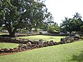
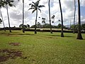
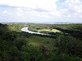
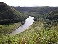
Wailua River State Park and the Wailua Complex of Heiaus, which it includes, are located on the eastern side of the Hawaiian island of Kauai. The park consists primarily of the Wailua River valley, which is the only navigable river in Hawaii. Visitors to this park can kayak, take riverboat cruises and explore the rainforest. Even motorboats and water skiing are permissible on the river.
Wailua Complex of Heiaus
The Wailua Complex, a National Historic Landmark, [2] was once the center of chiefly power on the island. It contains the remains of several important structures: places of worship (heiau), places of refuge (puʻuhonua), and sites related to royal births. [3] The most important sites are: [4]
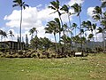
- Hikinaakalā (Rising of the Sun) Heiau, which includes the Hauola place of refuge (puʻuhonua) and the Kiʻi Pōhaku ancient petroglyphs, at the mouth of the river adjacent to Lydgate State Park [5]
- Malae, also known as Malaea or Makaukiu or Mana Heiau, a huge, rectangular luakini heiau almost 400 feet long on the south side of the river just above Highway 56 [5]
- Holoholokū Heiau, also known as Kalaeokamanu, adjacent to the pōhaku hoʻohānau (birthing stone) and pōhaku piko (navel/umbilical stone), where women of high rank would give birth and bury their afterbirth and umbilical cords [5]
- Poliʻahu (also spelled Poliahu) Heiau, a large luakini heiau high on the narrow ridge between ʻŌpaekaʻa Stream and Wailua River [5]
- Bellstone (on the same ridge), used to announce important events, such as royal births [5]
Of these, only Holoholokū has been largely restored. [4]
Heiau images
-
 Hikinaakalā Heiau
 -
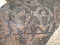 Kiʻi Pōhaku image
 -
 Hauola Heiau altar
 -
 Ka Lae O Ka Manu Heiau (from near birthing stones)
 -
 Poliʻahu Heiau (looking inland)
 -
 Poliʻahu Heiau (looking seaward)
 -
 Poliʻahu Heiau view of Wailua River mouth and Malae Heiau hillside
 -
 Poliʻahu Heiau view of Wailua River, Kamokila Hawaiian Village (at right), and Fern Grotto tour boat
 -
 Kamokila Hawaiian Village
 -

-
 Sketch by Hiram Bingham I


History
Wailua was the land of the ali'i (kings) and was one of the largest ahupuaʻa (subdivisions) on Kauai. It is said that King Kaumuali'i's favorite place to live was in Wailua. There are Hawaiian heiaus starting from the mouth of the river all the way to the summit of Mt.Waialeale. The huaka'i po (Ghost Warriors) are said to walk ancient trails along the river at night up to Mount Waiʻaleʻale. Wailua has many legends about it and was once home to many Hawaiians.
See also
References
- ^ "National Register Information System". National Register of Historic Places. National Park Service. January 23, 2007.
- ^ a b "Wailua Complex of Heiaus". National Historic Landmark summary listing. National Park Service. Retrieved July 3, 2008.
- ^ "Hawaii State Parks: Wailua River State Park". Retrieved December 5, 2009.
- ^ a b "NRHP Inventory—Nomination Form". Retrieved May 23, 2012.
- ^ a b c d e Kirch, Patrick Vinton (1996). "Heiau Complex at Wailua". Legacy of the Landscape: An Illustrated Guide to Hawaiian Archaeological Sites. Honolulu: University of Hawaii Press. pp. 16–19. ISBN 0-8248-1739-7.
| Topics | |
|---|---|
| Lists by state |
|
| Lists by insular areas | |
| Lists by associated state | |
| Other areas | |
| Related | |
| Authority control databases: National |
|---|
- Heiau
- State parks of Hawaii
- Properties of religious function on the National Register of Historic Places in Hawaii
- National Historic Landmarks in Hawaii
- Protected areas of Kauai
- Historic districts on the National Register of Historic Places in Hawaii
- National Register of Historic Places in Kauai County, Hawaii