| Upper Klamath National Wildlife Refuge | |
|---|---|
IUCN category IV (habitat/species management area) | |
 The Upper Klamath National Wildlife Refuge | |
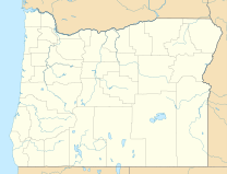
| Location | Klamath County, Oregon |
| Nearest city | Klamath Falls |
| Coordinates | 42°30′30″N 122°02′30″W / 42.508333°N 122.041667°W |
| Area | 14,400 acres (5,800 ha) [1] |
| Established | 1928 [2] |
| Governing body | U.S. Fish and Wildlife Service |
| Website | Upper Klamath NWR |
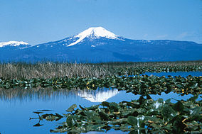
The Upper Klamath National Wildlife Refuge is a wildlife refuge in southwestern Klamath County on the shores of Upper Klamath Lake in Oregon. It was established in 1928 and contains some 14,400 acres (5,800 ha) [1] of freshwater marshes. It is accessible only by boat from Rocky Point Resort and Rocky Point boat launch, Malone springs, and a few neighboring ramps. The refuge is part of the Klamath Basin National Wildlife Refuge Complex and is administered along with the other refuges of the complex from common offices in Tulelake, California.
References
External links
-
 Media related to
Upper Klamath National Wildlife Refuge at Wikimedia Commons
 - "Upper Klamath National Wildlife Refuge". U.S. Fish and Wildlife Service.
