Torroella de Montgrí | |
|---|---|
,_Pla%C3%A7a_de_la_Vila.jpg) Weekly market on the main square | |
 Flag  Coat of arms | |
 Torroella de Montgrí Location in the Province of Girona  Torroella de Montgrí Location in Catalonia  Torroella de Montgrí Location in Spain | |
| Coordinates: 42°2′38″N 3°7′43″E / 42.04389°N 3.12861°E | |
| Country | |
| Autonomous community | |
| Province | Girona |
| Comarca | Baix Empordà |
| Judicial district | La Bisbal d'Empordà |
| Government | |
| • Mayor | Josep Maria Rufí (Jordi Cordon Pulido (2015) [1]) |
| Area | |
| • Total | 65.9 km2 (25.4 sq mi) |
| Elevation | 31 m (102 ft) |
| Population (2018)
[3] | |
| • Total | 11,537 |
| • Density | 180/km2 (450/sq mi) |
| Demonym | Montgrins |
| Time zone | UTC+1 ( CET) |
| • Summer ( DST) | UTC+2 ( CEST) |
| Postal code | 17257 |
| Website |
torroella-estartit |
Torroella de Montgrí (Catalan pronunciation: [turuˈeʎə ðə muŋˈɡɾi]) is a coastal municipality on the Costa Brava, and small town in Catalonia, Spain. The town lies on the north bank of the Ter river, a few kilometres before it flows into the Mediterranean. The beach resort of L'Estartit also is part of the municipality, as are the Medes Islands and a large part of the Montgrí Massif. [4]

The town is 22 km (14 mi) east of Girona and 5 km (3.1 mi) west of the resort of L'Estartit. It lies on the junction of the C-31 and GI-641. The town was originally the Royal Port for the Kings of Aragon before the river started silting up and a new port was founded at l'Estartit. The town retains its medieval core and walls and hosts a market every Monday.
The town is towered over by the Montgrí Massif on its northern side. The Montgrí is a long mountain formation that looks like a sleeping bishop seen from afar. Its vegetation consists mostly of low Mediterranean scrub among rocks. The maximum height of the range is 308 m (1,010 ft) and it is topped by an ancient fortress in the middle, the Montgrí Castle.
The town is a staging point on the GR 92 long distance footpath, which roughly follows the length of the Mediterranean coast of Spain. Stage 6, to the north, takes a largely inland route, starting with a climb to the Montgrí Castle and then crossing the Montgri Massif to reach the sea at L'Escala before the next staging point of Sant Martí d'Empúries, a distance of 20.0 kilometres (12.4 mi). Stage 7, to the south, takes an inland route, crossing the Ter river and continuing via Gualta, Fontanilles, Palau-sator and Pals to the next staging point at Begur, a distance of 21.3 kilometres (13.2 mi). [4] [5]
Gallery
-
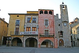 Plaça de la Vila
 -
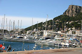 Estartit port
 -
 The Montgrí Massif
 -
 Castell de Montgrí


_-_3.jpg)
References
- ^ "Ajuntament de Torroella de Montgrí". Generalitat of Catalonia. Retrieved 2015-11-13.
- ^ "El municipi en xifres: Torroella de Montgrí". Statistical Institute of Catalonia. Retrieved 2015-11-23.
- ^ Municipal Register of Spain 2018. National Statistics Institute.
- ^ a b Empordà Costa Brava - Nord (Map). 1:30,000. Editorial PIOLET i Consell Comarcal del Baix Empordà. March 2012.
- ^ "GR 92: Sender de la Mediterrània" [GR 92: Mediterranean Path]. www.catalunya.com (in Catalan). Archived from the original on 7 November 2022. Retrieved 7 November 2022.
External links
-
 Torroella de Montgrí travel guide from Wikivoyage
 - Town Council Website
- Government data pages (in Catalan)
Places adjacent to Torroella de Montgrí | ||||||||||||||||
|---|---|---|---|---|---|---|---|---|---|---|---|---|---|---|---|---|
| ||||||||||||||||
| International | |
|---|---|
| National | |
| Geographic | |
| Other | |