This article needs additional citations for
verification. (September 2023) |
Tomarza | |
|---|---|
District and
municipality | |
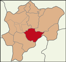
 Map showing Tomarza District in Kayseri Province | |
| Coordinates: 38°26′50″N 35°47′57″E / 38.44722°N 35.79917°E | |
| Country | Turkey |
| Province | Kayseri |
| Government | |
| • Mayor | Osman Koç [1] (TOMARZA İTTİFAKI) |
| Area | 1,405 km2 (542 sq mi) |
| Elevation | 1,330 m (4,360 ft) |
| Population (2022)
[2] | 21,100 |
| • Density | 15/km2 (39/sq mi) |
| Time zone | UTC+3 ( TRT) |
| Postal code | 38900 |
| Area code | 0352 |
| Website |
www |
Tomarza, formerly known as Dumarza ( Armenian: Դումարզա), is a municipality and district of Kayseri Province, Turkey. [3] Its area is 1,405 km2, [4] and its population is 21,100 (2022). [2] The mayor is Osman Koç ( İYİP).
Tomarza is a famous city for its pumpkin seeds production. According to Gida Tarim, [5] Tomarza is one of the important pumpkin seed production centers in Turkey. While 60 percent of the snack pumpkin seeds produced in Turkey are met by Kayseri, 25 percent of the production in Kayseri comes from the city of Tomarza. Pumpkin seeds will be planted on 40 thousand acres of land. In 2020, 5 thousand 500 tons of harvest were obtained from the pumpkin seeds for snacks planted on 40 thousand acres of land in Tomarza. Other important activities are potato production, and sheep, goat and cattle-raising.
Composition
There are 54 neighbourhoods in Tomarza District: [6]
- Akdere
- Akmezar
- Arslantaş
- Avşarsöğütlü
- Bektaş
- Böke
- Bostanlık
- Büyükcanlı
- Büyüksüvegen
- Çanakpınar
- Çayinli
- Cücün
- Çukurağaç
- Çulha
- Cumhuriyet
- Dadaloğlu
- Dağyurdu
- Ekinli
- Emiruşağı
- Göktepe
- Gülveren
- Güzelce
- Güzelsu
- Hacıpaşa
- İcadiye
- İmamkullu
- İncili
- Işıklar
- Kaleköy
- Kapıkaya
- Karamuklu
- Karaören
- Kesir
- Kevenağıl
- Kızılören
- Koçcagız
- Kömürköy
- Köprüköy
- Küçükcanlı
- Kurtuluş
- Melikören
- Pusatlı
- Sarımehmetli
- Şeyhbarak
- Şiraz
- Söğütlü
- Tahtakemer
- Tatarköy
- Toklar
- Turanlı
- Üçkonak
- Yavuz Selim
- Yeni
- Yeşilbağ
Climate
Tomarza has a warm summer continental climate (Dfb) with cold winters and very warm, dry summers with cool nights. Rainfall occurs mostly during the spring and early summer.
| Climate data for Tomarza, Kayseri province (1988-2012) | |||||||||||||
|---|---|---|---|---|---|---|---|---|---|---|---|---|---|
| Month | Jan | Feb | Mar | Apr | May | Jun | Jul | Aug | Sep | Oct | Nov | Dec | Year |
| Mean daily maximum °C (°F) | 1 (34) |
3 (37) |
8 (46) |
15 (59) |
19 (66) |
23 (73) |
27 (81) |
28 (82) |
24 (75) |
18 (64) |
10 (50) |
4 (39) |
15 (59) |
| Mean daily minimum °C (°F) | −9 (16) |
−7 (19) |
−3 (27) |
1 (34) |
4 (39) |
7 (45) |
9 (48) |
9 (48) |
5 (41) |
2 (36) |
−2 (28) |
−5 (23) |
1 (34) |
| Average precipitation mm (inches) | 38 (1.5) |
42 (1.7) |
44 (1.7) |
54 (2.1) |
55 (2.2) |
41 (1.6) |
11 (0.4) |
8 (0.3) |
17 (0.7) |
34 (1.3) |
38 (1.5) |
45 (1.8) |
427 (16.8) |
| Source: Weather2 [7] | |||||||||||||
References
- ^ "Kayseri Olay Haber". Retrieved 3 April 2024.
- ^ a b "Address-based population registration system (ADNKS) results dated 31 December 2022, Favorite Reports" (XLS). TÜİK. Retrieved 19 September 2023.
- ^ Büyükşehir İlçe Belediyesi, Turkey Civil Administration Departments Inventory. Retrieved 19 September 2023.
- ^ "İl ve İlçe Yüz ölçümleri". General Directorate of Mapping. Retrieved 19 September 2023.
- ^ "Kayseri'de kabak çekirdeği ekimi başladı". 17 May 2021.
- ^ Mahalle, Turkey Civil Administration Departments Inventory. Retrieved 19 September 2023.
- ^ "Tomarza, Turkey Travel Weather Averages (Weatherbase)".
External links


