From Wikipedia, the free encyclopedia
State park in California, United States
| Thornton State Beach | |
|---|---|
 | |
| Location | San Mateo County, California, United States |
| Nearest city | Daly City, California |
| Coordinates | 37°41′N 122°30′W / 37.683°N 122.500°W / 37.683; -122.500 |
| Area | 58 acres (23 ha) |
| Established | 1955 |
| Governing body | California Department of Parks and Recreation |
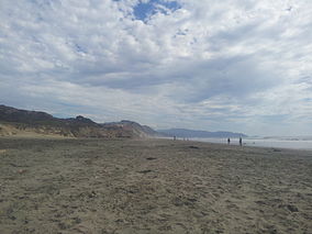
Thornton State Beach is a protected beach in the state park system of California, United States. It is located on the Pacific coast of Daly City in the San Francisco Bay Area. The 58-acre (23 ha) park was established in 1955. [1]
The Mediterranean climate tends toward cold and wind, with fog common in summer. [2]
The beach was named for the first white settler of the area, one Robert S. Thornton of Rhode Island, a blacksmith who had arrived in the San Francisco area in 1851.
The park was closed in 2009 due to damage and continued danger from landslides, [3] but as of late 2021 is fully open.

See also
References
-
^
"California State Park System Statistical Report: Fiscal Year 2009/10" (PDF). California State Parks: 30. Retrieved 2011-10-29.
{{
cite journal}}
: Cite journal requires|journal=( help) - ^ "Thornton SB". California State Parks. Retrieved 2010-03-03.
-
^ McIntire, Steven (2009-10-25). "Thornton State Beach, closed, but still open". examiner.com.
{{
cite web}}
: Missing or empty|url=( help)
External links
Retrieved from "
https://en.wikipedia.org/?title=Thornton_State_Beach&oldid=1061965303"

