Teteven
Тетевен | |
|---|---|
 Teteven Monastery of St Elias (17th century) | |
 Coat of arms | |
 Teteven Location of Teteven | |
| Coordinates: 42°55′4.71″N 24°15′49.91″E / 42.9179750°N 24.2638639°E | |
| Country | Bulgaria |
|
Province (Oblast) | Lovech |
| Government | |
| • Mayor | Dr. Madlena Boyadzhieva |
| Elevation | 412 m (1,352 ft) |
| Population (15.12.2010)
[1] | |
| • City | 10,733 |
| • Urban | 21,374 |
| Time zone | UTC+2 ( EET) |
| • Summer ( DST) | UTC+3 ( EEST) |
| Postal Code | 5700 |
| Area code | 0678 |
Teteven ( Bulgarian: Тетевен, pronounced [ˈtɛtɛvɛn]) is a town on the banks of the Vit, at the foot of the Balkan mountains in north central Bulgaria. It is the administrative centre of the Teteven Municipality which is a part of Lovech Province. As of December 2010, the town had a population of 10,733 inhabitants. [1]
Geography
Teteven is located in a mountainous area, in the foothills of the Balkan mountains between the peaks Ostrich, Petrahilya, Cherven, Treskavets and Vezhen. The river Vit meanders through the town. The altitude of Teteven district varies from 340 to 2100 m, and in the town center it is 415 m. The climate is temperate continental with cold winters and cool summers. The territory of Teteven is about 697 km2, which is 16.86% of the territory of Lovech district.
History

The town was first mentioned in a written document in 1421. It is thought that the town's name comes from the family of a certain Tetyo (Tetyov rod), who settled in the area and founded the town. Older variants of the town's name found in documents are Tetyuven and Tetyuvene.
A thriving city in the 16th and 17th centuries, Teteven was raided by organised Turkish brigand groups in 1801, burnt down and almost completely destroyed, with only four houses surviving out of a total of 3,000. The town later revived and was active in the armed struggle for Bulgarian independence in the 19th century, sheltering a revolutionary committee part of Vasil Levski's organised rebel network.
Each summer a large chess tournament, one of the biggest events in Bulgaria's chess calendar, is held in Teteven.
Honour
Teteven Glacier on Livingston Island in the South Shetland Islands, Antarctica is named after Teteven.
Sights
Teteven combines the beauty of the surrounding scenery with the towering hills and peaks Petrahilya, Ostrich, Cherven and Ravni Kamak (they have witnessed many historical events), the cool breeze of the Vit river, and the spirit of centuries past, hovering in the multitude of monuments, ancient Bulgarian architecture, and customs and manners that have remained intact in time. Astounded by the sights revealed before him in his visit to the town, Ivan Vazov has exclaimed: "Had I not come to Teteven, I would have remained a foreigner to mother Bulgaria ... I have been wandering, I have been rambling, but I have not seen a more wondrous paradise."
There is a historical museum in Teteven, which is among the Hundred National Tourist Sites of the Bulgarian Tourist Union.
Sights of Teteven and the Teteven district
- Glozhene Monastery
- Saint Elijah Monastery (14th century)
- All Saints Church
- Kosnitza waterfall
- Mother of God Shroud Chapel on Ostrich peak
- Boev hill
Caves
- Saeva Dupka
- Morovitza
- Baiovitza
- Draganchovitza
- Rushova cave (near Gradezhnitza village)
Museums
- Teteven Historical Museum
- Bobevska house museum
- Hadzhiivanova house museum
- Yorgova house museum
Regular events
- Autumn fair
- Northern Song Feast (May)
- The Feast of Teteven on November 1, the day the town was liberated from Ottoman domination in 1877
- Days of Mountain Water and Healing Tourism, Scientific Research Center of Medical Biophysics, Teteven municipality, June 11
Gallery
-
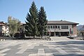 Teteven Municipality Hall
 -
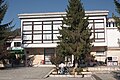 Teteven Chitalishte (Culture club)
 -
 All Saints Church in Teteven
 -
 A 19th-century house
 -
 A 19th-century house


Persons
Notable persons born in Teteven
This article's list of residents may not follow Wikipedia's
verifiability policy. (March 2017) |
- Lyubomir Bobevski — writer
- Nikola Bobevski — artisan, elected Teteven delegate on the occasion of the signing of the San Stefano Peace Treaty
- Valentin Bobevski — conductor
- Sabo Dimitrov — artist
- Mihail Ekimdzhiev — lawyer
- Valentin Grozev (1950-2010) — artist
- Ignat Ignatov — professor, biophysicist
- Usin Kerim — poet
- Dimitar Krachidzhov — poet and publicist
- Iva Krasteva — sports journalist, lives and works in London
- Banyo Marinov (1853-1879) — revolutionary
- Nikola Merekiov — actor and agriculturalist
- Sava Mladenov — adherent of Vasil Levski and a revolutionary from Hristo Botev's armed group
- Preslava Mravkova — singer (Music Idol)
- Vera Naidenova — Bulgarian professor, film critic
- Svilen Rusinov — sportsman, honorary citizen of Teteven
- Hristo Spasunin (1923-2010) — poet and publicist
- Ivailo Stanev — photographer
- Nikola Tiholov — scriptwriter
- Margarit Tzanev — artist
- Ivan Undzhiev (1902-1979) — Bulgarian professor-historian
- Nikolai Vitanov — professor, nuclear physicist
- Hadji Stanyo Vrabevski — chairman of the local revolutionary committee, sent into exile in Diyarbakır
Notable persons who have died in Teteven
This article's list of residents may not follow Wikipedia's
verifiability policy. (March 2017) |
- Georgi Benkovski (1843-1876) — Bulgarian revolutionary
- Atanas Murdzhev (1875-1944) — Bulgarian revolutionary
See also
References
- ^ a b (in English) Bulgarian National Statistical Institute - Bulgarian towns in 2009
External links
- Teteven municipality portal (Bulgarian version)
- Teteven municipality portal (English version)
- Days of Mountain Water and Healing Tourism (English version) Teteven Municipality, Scientific Research Center of Medical Biophysics

42°55′N 24°16′E / 42.917°N 24.267°E
| International | |
|---|---|
| National | |