| This article is rated List-class on Wikipedia's
content assessment scale. It is of interest to the following WikiProjects: | ||||||||||||||||||||||||
| ||||||||||||||||||||||||


As with other state-wide lists of RHPs, it is necessary to split out bigger counties, at least, to keep page filesize manageable. Someone reverted my splitting out El Paso County, at least on this end, perhaps assuming my split was unfriendly. However, it is I that have been the main person developing this list-article by putting in tables, it was not unfriendly to anyone that i know of who may be watching. Anyhow, please feel free to discuss here. doncram ( talk) 16:48, 29 January 2009 (UTC)
- I didn't think it was unfriendly, I didn't know there was a rationale to it. Thank you for the explanation. Chris (クリス • フィッチ) ( talk) 06:36, 30 January 2009 (UTC)
- From the Delta county old list, in Crawford: North Rim Road, Black Canyon of the Gunnison National Park, not in Elkman table. is this new, and/or is it right location? More info: Crawford is in Delta County. The entry appears, however, in the Elkman table for Montrose County. It could be that the place is in Montrose county, but nearest major town is Crawford in Delta county? Or, is there a county error in the NRIS database? doncram ( talk) 19:36, 7 February 2009 (UTC)
- In Hugo, is Hugo Municipal Pool NRHP-listed? Is it new, hence not in table?
- from Park County, in Fairplay or vicinity, the Trout Creek-Annex-Settele Ranch: new listing? not in table
- In Saguache County, in Moffat, First Baptist Church of Moffat: is it NRHP-listed? is it new? not in 4/2008 NRIS-based table
- In Las Animas County, in Kim, besides Kim Schools is there also a White School NRHP-listed? White School appeared in the old list, is not a row in new table.
- Are there other new listings, later than mid April 2008, for which rows have not yet been created? Probably... sanfranman59, if u r reading this, it would be great if you could paste in here your list of recent Colorado additions/changes for me to address. doncram ( talk) 19:36, 7 February 2009 (UTC)
- delistings. Small tables for delistings in each applicable county are needed. Info about each delisting is available at state Colorado Historical Society website. I put link into wp:NRHP state specific resources. doncram ( talk) 19:36, 7 February 2009 (UTC)
- A complete list of delistings can be found at this website, apparently the Colorado Historic Society site that Doncram means. Please note that this includes the state's register, too, so one must be careful with dates and with making sure that a site was National Register-listed, not just state-listed. Nyttend ( talk) 14:45, 25 February 2009 (UTC)
The image File:HotelColorado GB5043.jpeg is used in this article under a claim of fair use, but it does not have an adequate explanation for why it meets the requirements for such images when used here. In particular, for each page the image is used on, it must have an explanation linking to that page which explains why it needs to be used on that page. Please check
- That there is a non-free use rationale on the image's description page for the use in this article.
- That this article is linked to from the image description page.
This is an automated notice by FairuseBot. For assistance on the image use policy, see Wikipedia:Media copyright questions. --04:08, 8 February 2009 (UTC)
You're still getting photo overlap, at least on Firefox. The left column of photos overlaps the table -- which is why I moved them to the right. Maybe there's another fix? Regards, Pete Tillman ( talk) 06:06, 11 March 2009 (UTC)
- Bump. Still a problem. Pete Tillman ( talk) 04:39, 4 April 2009 (UTC)
I haven't got a usr acct to upload imgs, but I was recently in Trout Lake and shot a few pics of the Water tank. So I put 3 shots of the tank and 1 pana of the Sheep Mt. ridge here if anybody wants to add them. (The exif data should still be attached if one needs to verify usage rights.)
First time posting on Wpedia, -sorry if i didn't follow protocol or broke any rules. —Preceding unsigned comment added by 66.251.234.27 ( talk) 01:40, 24 April 2009 (UTC)
Have created a new Colorado map for your use, showing NRHPs by county. file:NRHP Colorado Map.svg 25or6to4 ( talk) 21:30, 30 May 2009 (UTC)
Presently engaged in historic one room schoolhouses, there is one in Gunnison, Gunnison County, Colorado, U.S.A., leasing the upper floor of the Gunnison Arts Center. Anyone care to discuss this? O=MC4 20:39, 9 June 2012 (UTC), User:Orschstaffer/Schoolhouse
Hello fellow Wikipedians,
I have just modified one external link on National Register of Historic Places listings in Colorado. Please take a moment to review my edit. If you have any questions, or need the bot to ignore the links, or the page altogether, please visit this simple FaQ for additional information. I made the following changes:
- Added archive https://web.archive.org/web/20130902104443/http://crowleyheritagecenter.com/images/stories/cchcbrochure2011.pdf to http://www.crowleyheritagecenter.com/images/stories/cchcbrochure2011.pdf
When you have finished reviewing my changes, you may follow the instructions on the template below to fix any issues with the URLs.
This message was posted before February 2018.
After February 2018, "External links modified" talk page sections are no longer generated or monitored by InternetArchiveBot. No special action is required regarding these talk page notices, other than
regular verification using the archive tool instructions below. Editors
have permission to delete these "External links modified" talk page sections if they want to de-clutter talk pages, but see the
RfC before doing mass systematic removals. This message is updated dynamically through the template {{
source check}} (last update: 18 January 2022).
- If you have discovered URLs which were erroneously considered dead by the bot, you can report them with this tool.
- If you found an error with any archives or the URLs themselves, you can fix them with this tool.
Cheers.— InternetArchiveBot ( Report bug) 23:23, 24 January 2018 (UTC)
User:CaroleHenson, anyone else, wanna work on cleaning up "NRIS-only" ones? Arguably the worst NRHP articles in the state. Current results of Petscan search for Colorado NRHPs with "NRIS-only" status:
- 1
Echo Lake Park--i added NRHP document reference and a very little bit more. Article coverage of park vs. lake could be better done; more could be used from NRHP document. Not sure if this should be struck out or not, really. -- Doncram ( talk) 00:38, 16 June 2018 (UTC) - 2
Central City Opera House--CH interest - I added NRHP document reference, some citations, organized the info into sections and made a few edits.– CaroleHenson ( talk) 07:31, 16 June 2018 (UTC) - 3
Town Hall Arts Center Done–
CaroleHenson (
talk) 03:53, 29 June 2018 (UTC)
Done–
CaroleHenson (
talk) 03:53, 29 June 2018 (UTC) - 4
Humboldt Street Historic District Done–
CaroleHenson (
talk) 04:19, 28 June 2018 (UTC) - 5
American National Bank Building (Alamosa, Colorado) Done–
CaroleHenson (
talk) 13:26, 29 June 2018 (UTC) - 6
Cornwall Apartments Done–
CaroleHenson (
talk) 14:37, 29 June 2018 (UTC) - 7
GlenisleAdded a bit. It would be nice if anyone near Denver could get a few more pics. :) -- Doncram ( talk) 01:09, 26 June 2018 (UTC) - 8
Golden High Schoolfinished total rewrite of uncited article. Done–
CaroleHenson (
talk) 20:23, 29 June 2018 (UTC) - 9
Chautauqua Auditorium (Boulder, Colorado)--of interest to CH. Only added NRHP doc reference. -- Doncram ( talk) 15:26, 22 September 2018 (UTC) - 10
Quaintance Block - 11
Loveland Block and Coors Building - 12
Victor Downtown Historic District-- maybe CH will merge with Victor, Colorado?
- 13
Midland Terminal Railroad Depot--CH interest - I added some additional information and citations.– CaroleHenson ( talk) 02:35, 21 June 2018 (UTC) - 14
Astor House (Colorado)added a bit; leaving refimprove tag still -- Doncram ( talk) 20:44, 27 August 2018 (UTC) - 15
Colorado Amphitheater - 16
Barnes–Peery House - 17
Herman Coors House - 18
Eldora Historic District
- 19
South Canon Bridge-- Doncram ( talk) 17:03, 2 September 2018 (UTC) - 20
SLW Ranch - 21
William H. McCreery House - 22
Arvada Downtown - 23
Arvada Flour Mill - 24
Auraria 9th Street Historic District - 25
City Park Golf - 26
Atchison, Topeka and Santa Fe Passenger Depot (Colorado Springs, Colorado) - 27
Smith's Irrigation Ditch - 28
Evans Memorial Chapel-- Doncram ( talk) 00:57, 16 September 2018 (UTC) - 29
St. John's Greek Orthodox Church (Pueblo, Colorado) - 30
Pueblo Federal Building - 31
Quaker Flour Mill<-- DenverJeffrey mentions he might be able to get another pic sometime :) - 32
Rood Candy Company Building-- Doncram ( talk) 02:35, 8 September 2018 (UTC) - 33
Young Women's Christian Association (Pueblo, Colorado)--added NRHP doc, started Walter DeMourdant architect stub article. -- Doncram ( talk) 17:17, 7 July 2018 (UTC) Quite short. -- Doncram ( talk) 02:35, 8 September 2018 (UTC) - 34
Temple Emanuel (Pearl Street, Denver) - 35
Union Warehouse - 36
Peters Paper Company Warehouse - 37
William Smith House (Aurora, Colorado) - 38
Owen Estate - 39
Little Estate - 40
Maitland Estate - 41
Knight-Wood House - 42
Comanche Crossing of the Kansas Pacific Railroad--CH interest Done–
CaroleHenson (
talk) 16:28, 25 June 2018 (UTC) - 43
Arapahoe Acres-CH interest Done–
CaroleHenson (
talk) 18:50, 25 June 2018 (UTC) - 44
First Baptist Church (Greeley, Colorado) - 45
Derry Mining Site Camp - 46
Hayden Ranch Headquarters - 47
Green Mountain Ranch - 48
Cañon City Municipal Building - 49
First Baptist Church (Alamosa, Colorado)Nom and a bit more added. -- Doncram ( talk) 14:36, 17 June 2018 (UTC) - 50
Sacred Heart Catholic Church (Alamosa, Colorado)Nom and a bit more added. -- Doncram ( talk) 14:36, 17 June 2018 (UTC) - 51
St. Thomas Episcopal Church (Alamosa, Colorado), nom and a bit added. -- Doncram ( talk) 15:37, 29 July 2018 (UTC) - 52
Methodist Episcopal Church (Idaho Springs, Colorado), nom and a bit added. -- Doncram ( talk) 15:37, 29 July 2018 (UTC) - 53
Hotchkiss Methodist Episcopal Church-- Doncram ( talk) 00:57, 16 September 2018 (UTC) - 54
Central Presbyterian Church (Denver, Colorado)-- Doncram ( talk) 00:57, 16 September 2018 (UTC) - 55
Christ Methodist Episcopal Church-- Doncram ( talk) 00:57, 16 September 2018 (UTC) - 56
St. Mark's Parish Church-- Doncram ( talk) 00:57, 16 September 2018 (UTC) - 57
Temple Emanuel (Curtis Street, Denver, Colorado) - 58
Annunciation Roman Catholic Church (Denver) - 59
Montview Boulevard Presbyterian Church - 60
St. Elizabeth's Church (Denver, Colorado) - 61
St. Ignatius Loyola Church (Denver, Colorado) - 62
St. Joseph's Roman Catholic Church (Denver) - 63
All Saints Episcopal Church (Denver) - 64
St. Dominic's Church (Denver, Colorado) - 65
St. Elizabeth's Retreat Chapel - 66
St. Joseph's Polish Roman Catholic Church - 67
St. Patrick Mission Church - 68
Church of St. Philip-in-the-Field and Bear Canon Cemetery - 69
Ruth Memorial Methodist Episcopal Church - 70
Emmanuel Presbyterian Church (Colorado Springs, Colorado) Done–
CaroleHenson (
talk) 19:13, 8 July 2018 (UTC) - 71
First Congregational Church (Manitou Springs, Colorado) Done–
CaroleHenson (
talk) 18:53, 8 July 2018 (UTC) - 72
First Presbyterian Church of Ramah-- Doncram ( talk) 01:20, 29 June 2018 (UTC) - 73
Christ Episcopal Church (Cañon City, Colorado)Brief, maybe too brief. -- Doncram ( talk) 02:13, 2 July 2018 (UTC) - 74
First Presbyterian Church (Cañon City, Colorado)Okay. -- Doncram ( talk) 02:13, 2 July 2018 (UTC) - 75
First Christian Church (Trinidad, Colorado) - 76
First Methodist Episcopal Church (Trinidad, Colorado) - 77
Zion's German Lutheran Church - 78
First United Presbyterian Church (Sterling, Colorado) - 79
Clifton Community Center and Church - 80
German Evangelical Immanuel Congregational Church - 81
St. James Episcopal Church (Meeker, Colorado) - 82
First Methodist Episcopal Church (Monte Vista, Colorado) - 83
Amanda K. Alger Memorial Methodist Episcopal Church - 84
First Methodist Episcopal Church (Windsor, Colorado) - 85
United Church of Christ of Highlandlake
- --
Doncram (
talk) 23:34, 15 June 2018 (UTC)
- Rather than repeat myself, I answered
here about the ones I'm interested in.–
CaroleHenson (
talk) 23:48, 15 June 2018 (UTC)
- (ec) Discussing elsewhere, CH has noted interest in a number, some noted by me above.
- The main thing on all of these is to add the great NRHP nomination/registration document, with photos, that is now available for almost all of these, which all were created as articles (and were NRHP-listed) by 2013. -- Doncram ( talk) 01:29, 16 June 2018 (UTC)
- Rather than repeat myself, I answered
here about the ones I'm interested in.–
CaroleHenson (
talk) 23:48, 15 June 2018 (UTC)
I saw your comment, Doncram, about getting a picture for Glenisle. I think its about an hour drive from Denver, more with Denver metro traffic. I can send an email to the resort and see if they can load/release some photos onto commons. If it doesn't come through, we can add a picture request to the talk page... or perhaps someone sees this and is willing to go there - or lives near it - and can take some pictures.– CaroleHenson ( talk) 03:38, 26 June 2018 (UTC)
- Hey User:CaroleHenson, if you'll get a pic for that one, I'll make the trek to another out-of-the-way one, say, how about Coates Creek Schoolhouse, to match. Or what else do you have to offer? :) -- Doncram ( talk) 02:22, 31 August 2018 (UTC)
- Apparently 33 done; 52 remain per query link at top of this section. --
Doncram (
talk) 17:03, 2 September 2018 (UTC)
- Petscan link says 49 remain now. --
Doncram (
talk) 06:07, 5 September 2018 (UTC)
- petscan reports 36 now. --
Doncram (
talk) 02:06, 17 September 2018 (UTC)
- Okay, all done, at least in that all now have their NRHP document as a reference, if the NRHP document is available, and otherwise have some other inline sourcing. Some were developed a bit more, but many were just minimally improved. However even just a link to the NRHP document can make quite a lot of difference for a reader interested in a given site. Thanks User:CaroleHenson for your participation which helped this along. -- Doncram ( talk) 15:26, 22 September 2018 (UTC)
- petscan reports 36 now. --
Doncram (
talk) 02:06, 17 September 2018 (UTC)
- Petscan link says 49 remain now. --
Doncram (
talk) 06:07, 5 September 2018 (UTC)
I am a little confused. This listing is under Bent County, Colorado, but Bent's New Fort is in Prowers County, Colorado. Is is under the right county? Or, should it also be under Prowers County?– CaroleHenson ( talk) 05:01, 16 June 2018 (UTC)
- I see why Wikipedia NRHP editors put it into National Register of Historic Places listings in Bent County, Colorado: the NPS "Weekly listings" announcement of its listing gives:
COLORADO, BENT COUNTY,
Santa Fe Trail Mountain Route--Bent's New Fort,
Address Restricted,
Lamar vicinity, 16000666,
LISTED, 9/26/16
(Santa Fe Trail MPS)
- And while the "vicinity" city is sometimes across a county line,
in this case Lamar is in fact in Bent County.Oops, right it is Prowers, across the line, I see from Google maps search on "Bent County, Colorado" and "Prowers County, Colorado". -- Doncram ( talk) 17:33, 16 June 2018 (UTC) - I don't see where Prowers County is coming in to anything. What makes you think Bent's New Fort is in that county?
- But perhaps the NRHP listing, which by its name probably includes a stretch of the Mountain Route trail, may in fact span across counties, without regular Wikipedia NRHP editors' knowledge, in which case an entry for it should be added to National Register of Historic Places listings in Prowers County, Colorado. And there needs to be careful discussion of the NRHP listing, as surely being larger than just the fort, but this is hard because we don't have the NRHP nomination document. -- Doncram ( talk) 15:19, 16 June 2018 (UTC)
- Bent's New Fort is in Lamar per this, but west of the center of town so it's possibly on / over the county border. The Lamar, Colorado article says "Lamar is a Home Rule Municipality that is the county seat and the most populous municipality of Prowers County, Colorado, United States.[8]". In addition, I tried to change the category for the New Fort image in commons to Bent County, and someone switched it back to Prowers.
- The Lamar article doesn't say it's in two counties. Pretty confused.– CaroleHenson ( talk) 15:30, 16 June 2018 (UTC)
- Oh, I was able to find out where the Prowers County border is, and it is in Bent's County. Thanks!– CaroleHenson ( talk) 15:46, 16 June 2018 (UTC)
I'd like to reorganize the breakout of Colorado counties into regional groupings, by any reasonable partition of the state. The small counties that are near to one another can be listed on a regional page, and then the corresponding "Map of all coordinates" will show all the listings in a coherent geographic area. I figure browsing will then be more satisfying for readers, for photographers, and for the relatively few editors actively developing NRHP articles in the state.
For example, perhaps the grouping of counties of the map of peace officer training regions and grants might work. That has 10 regions: Northwest, I-70 West, West Central, Southwest, San Luis Valley, Central Mountains, Greater Metro, Southeast, Northeast, North Central.
Or the 8-region Colorado Education map: Northwest, West Central, Southwest, Metro, Pikes Peak, Southeast, Northeast, North Central. -- Doncram ( talk) 23:12, 17 September 2018 (UTC)
- Sorry for the delayed reply,
Doncram! I cannot see the first map, but the 8-region map looks good. Could we use Denver Metro for Metro?–
CaroleHenson (
talk) 17:51, 11 February 2019 (UTC)
- Hi, np, thanks for reply. Sure "Denver Metro" as label is better than "Metro". But, hmm, the 8-region map of school district regions doesn't line up completely with county borders, there are a bunch of school districts spanning county lines at the edges of many of the 8 regions. Could a slightly modified map, adjusted, work? But then we wouldn't be hanging our hat on someone else's partition, which would be much more easily explained. -- Doncram ( talk) 18:07, 11 February 2019 (UTC)
- Any partition has to divide up the state into chunks of NRHPs, none having too many NRHPs to cover. Denver alone has 297 NRHPs, on the large side but okay on its own. So the partition then has to divvy up the rest of the state.
- There are 7 health care regions in Colorado Health Institute's partition for contracting health care, but the 7 parts aren't given names besides the health care contractor names, so would require us to coin names for the areas, if not use just region numbers 1 to 7. I dunno: "Denver", then making up names: "West", "Southeast", "Northeast", "Boulder etc", "Park-Teller-El Paso", "Arapahoe etc"? Probably those coinings don't work; for example "West" might have too many NRHPs. -- Doncram ( talk) 18:19, 11 February 2019 (UTC)
- There are 14 regions in economic development schema of "Choose Colorado", https://choosecolorado.com/, defined as groups of counties. Could split out Denver from the Denver region one, to make 15. Maybe some of the smaller regions (by number of NRHPs) could be combined. -- Doncram ( talk) 18:41, 11 February 2019 (UTC)
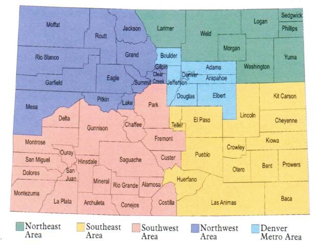
- http://www.easteregghuntsandeasterevents.org/maps/COmap2.jpg is a simple division by 5: Northeast, Northwest, Southwest, Southeast, Denver Metro. Split out Denver from Denver Metro to make 6. I may try to see how many NRHPs in each of these "6 regions". -- Doncram ( talk) 19:21, 11 February 2019 (UTC)
|
|||||||||||||||||||||||||||||||||||||||||||||||||||||||||||||||||||||||||||||||||||||||||||||||||||||||||||||||||||||||||||||||||||||||||||||||||||||||||||||||||||||||||||||||||||||||||||||||||||||||||||||||||||||||||||||||||||||||||||||||||||||||||||||||||||||||||||||||||||||||||||||||
References
- ^ 19th Street Bridge (Downtown Denver and West Denver), East Sixth Avenue Parkway (Northeast Denver and Southeast Denver), Monaco Street Parkway (Northeast Denver and Southeast Denver), South Platte River Bridges (Northeast Denver and West Denver), and Speer Boulevard (Downtown Denver, Northeast Denver, and Southeast Denver).
- ^ The following sites are listed in multiple counties: Alpine Tunnel Historic District (Chaffee and Gunnison), Boreas Railroad Station Site (Park and Summit), Colorado Millennial Site (Baca and Las Animas), Denver & Rio Grande Railroad San Juan Extension (Archuleta and Conejos), Denver, Northwestern and Pacific Railway Historic District (Boulder, Gilpin and Grande), Durango-Silverton Narrow-Gauge Railroad (La Plata and San Juan), North Inlet Trail (Larimer and Grand), Riverside Cemetery (Adams and Denver), Staunton Ranch-Rural Historic Landscape (Jefferson and Park), Tobasco Mine and Mill (Hinsdale and San Juan), Tonahutu Creek Trail (Larimer and Grand), Trail Ridge Road (Larimer and Grand) and Ute Mountain Ute Mancos Canyon Historic District (La Plata and Montezuma).
At present, the section headings for the various counties are wikilinked to the county's article. Per MOS:NOSECTIONLINKS, these links should be removed, leaving just the county name. Senator2029 【talk】 18:40, 10 October 2021 (UTC)
- List-Class National Register of Historic Places articles
- High-importance National Register of Historic Places articles
- List-Class National Register of Historic Places articles of High-importance
- List-Class United States articles
- Low-importance United States articles
- List-Class United States articles of Low-importance
- List-Class Colorado articles
- Mid-importance Colorado articles
- WikiProject Colorado articles
- WikiProject United States articles