Subprefecture of Sé | |
|---|---|
 Location of the Subprefecture of Sé in São Paulo | |
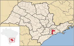
 Location of municipality of São Paulo within the State of São Paulo | |
| Country | |
| Region | Southeast |
| State |
|
| Municipality |
|
| Administrative Zone | Central |
| Districts | Bela Vista, Bom Retiro, Cambuci, Consolação, Liberdade, República, Sé, Santa Cecília |
| Government | |
| • Type | Subprefecture |
| • Subprefect | Nevoral Alves Bucheroni |
| Area | |
| • Total | 26.56 km2 (10.25 sq mi) |
| Population (2008) | |
| • Total | 328,597 |
| Website | Subprefeitura Sé (Portuguese) |
The Subprefecture of Sé is one of 32 subprefectures of the city of São Paulo, Brazil. It comprises eight districts: Bela Vista, Bom Retiro, Cambuci, Consolação, Liberdade, República, Sé, Santa Cecília. [1] This subprefecture forms the inner city, historical core of the city. The São Paulo Stock Exchange is also located in this area.
See also
References
External links
23°33′04″S 46°38′03″W / 23.5511°S 46.6342°W