Spring Street | ||||||||||||||||||||||||||||||||||||||||||||||||||||||||||||||||||||
|---|---|---|---|---|---|---|---|---|---|---|---|---|---|---|---|---|---|---|---|---|---|---|---|---|---|---|---|---|---|---|---|---|---|---|---|---|---|---|---|---|---|---|---|---|---|---|---|---|---|---|---|---|---|---|---|---|---|---|---|---|---|---|---|---|---|---|---|---|
|
| ||||||||||||||||||||||||||||||||||||||||||||||||||||||||||||||||||||
 | ||||||||||||||||||||||||||||||||||||||||||||||||||||||||||||||||||||
| Station statistics | ||||||||||||||||||||||||||||||||||||||||||||||||||||||||||||||||||||
| Address |
Spring Street &
Sixth Avenue New York, NY 10013 | |||||||||||||||||||||||||||||||||||||||||||||||||||||||||||||||||||
| Borough | Manhattan | |||||||||||||||||||||||||||||||||||||||||||||||||||||||||||||||||||
| Locale | Hudson Square, SoHo | |||||||||||||||||||||||||||||||||||||||||||||||||||||||||||||||||||
| Coordinates | 40°43′32″N 74°00′15″W / 40.725503°N 74.004035°W | |||||||||||||||||||||||||||||||||||||||||||||||||||||||||||||||||||
| Division | B ( IND) [1] | |||||||||||||||||||||||||||||||||||||||||||||||||||||||||||||||||||
| Line | IND Eighth Avenue Line | |||||||||||||||||||||||||||||||||||||||||||||||||||||||||||||||||||
| Services |
A
C E | |||||||||||||||||||||||||||||||||||||||||||||||||||||||||||||||||||
| Transit | ||||||||||||||||||||||||||||||||||||||||||||||||||||||||||||||||||||
| Structure | Underground | |||||||||||||||||||||||||||||||||||||||||||||||||||||||||||||||||||
| Platforms | 2 side platforms | |||||||||||||||||||||||||||||||||||||||||||||||||||||||||||||||||||
| Tracks | 4 | |||||||||||||||||||||||||||||||||||||||||||||||||||||||||||||||||||
| Other information | ||||||||||||||||||||||||||||||||||||||||||||||||||||||||||||||||||||
| Opened | September 10, 1932 [2] | |||||||||||||||||||||||||||||||||||||||||||||||||||||||||||||||||||
| Opposite- direction transfer | Yes | |||||||||||||||||||||||||||||||||||||||||||||||||||||||||||||||||||
| Traffic | ||||||||||||||||||||||||||||||||||||||||||||||||||||||||||||||||||||
| 2022 | 2,509,293
[4] | |||||||||||||||||||||||||||||||||||||||||||||||||||||||||||||||||||
| Rank | 123 out of 423 [4] | |||||||||||||||||||||||||||||||||||||||||||||||||||||||||||||||||||
| ||||||||||||||||||||||||||||||||||||||||||||||||||||||||||||||||||||
| ||||||||||||||||||||||||||||||||||||||||||||||||||||||||||||||||||||
| ||||||||||||||||||||||||||||||||||||||||||||||||||||||||||||||||||||
| ||||||||||||||||||||||||||||||||||||||||||||||||||||||||||||||||||||
| ||||||||||||||||||||||||||||||||||||||||||||||||||||||||||||||||||||


The Spring Street station is a local station on the IND Eighth Avenue Line of the New York City Subway. Located at Spring Street and Sixth Avenue (Avenue of the Americas) in the Hudson Square and SoHo neighborhoods of lower Manhattan, it is served by the C and E trains, the former of which is replaced by the A train during late nights.
History
Construction and opening
New York City mayor John Francis Hylan's original plans for the Independent Subway System (IND), proposed in 1922, included building over 100 miles (160 km) of new lines and taking over nearly 100 miles (160 km) of existing lines. The lines were designed to compete with the existing underground, surface, and elevated lines operated by the Interborough Rapid Transit Company (IRT) and Brooklyn–Manhattan Transit Corporation (BMT). [5] [6] On December 9, 1924, the New York City Board of Transportation (BOT) gave preliminary approval for the construction of the IND Eighth Avenue Line. [7] This line consisted of a corridor connecting Inwood, Manhattan, to Downtown Brooklyn, running largely under Eighth Avenue but also paralleling Greenwich Avenue and Sixth Avenue in Lower Manhattan. [7] [8] The BOT announced a list of stations on the new line in February 1928, with a local station at Spring Street and Sixth Avenue. [9]
Most of the Eighth Avenue Line was dug using a cheap cut-and-cover method. [10] [11] The Spring Street station was to be one of three Eighth Avenue Line stations underneath Sixth Avenue in Lower Manhattan; the other two stations were to be at Canal Street and West Fourth Street. [9] As part of the construction of the Eighth Avenue Line in Lower Manhattan, Sixth Avenue was extended south to Church Street starting in 1926. [12] This required the demolition of dozens of buildings along the route. [13] By August 1930, the BOT reported that the Eighth Avenue Line was nearly completed, except for the stations between Chambers Street–Hudson Terminal and West Fourth Street (including the Spring Street station), which were only 21 percent completed. [14] The entire line was completed by September 1931, except for the installation of turnstiles. [15]
A preview event for the new subway was hosted on September 8, 1932, two days before the official opening. [16] [17] The Spring Street station opened on September 10, 1932, as part of the city-operated IND's initial segment, the Eighth Avenue Line between Chambers Street and 207th Street. [18] [19] When the station opened in 1932, it was served by local AA trains. When the IND Concourse Line opened on July 1, 1933, [20] all locals became CC trains to the Concourse Line. [21] The E began using the local tracks on August 19, 1933, when the IND Queens Boulevard Line opened. [22]
Later years
The New York City Board of Transportation announced plans in November 1949 to spend $325,000 extending platforms at several IND stations, including Canal Street, to accommodate 11-car, 660-foot (200 m) trains. [23] [24] The lengthened trains began running during rush hour on September 8, 1953, with eleven-car trains operating on weekdays. [25]: 37–38 The project cost $400,000 and increased the total carrying capacity of rush-hour trains by 4,000 passengers. [26] The operation of eleven-car trains ended in 1958 because of operational difficulties. The signal blocks, especially in Manhattan, were too short to accommodate the longer trains, and the motormen had a very small margin of error to properly align the train with the platform. It was found that operating ten-car trains allowed for two additional trains per hour to be scheduled. [27]
The station was renovated as part of the 2010–2014 MTA Capital Program. An MTA study conducted in 2014 found that 31% of station components were out of date. [28]
Station layout
| Ground | Street level | Exit/entrance |
| Platform level | Side platform | |
| Northbound local | ←
← ← | |
| Northbound express | ←
| |
| Southbound express |
| |
| Southbound local |
| |
| Side platform | ||
| Basement 2 | Crossunder | Connection between platforms |
_03.jpg)
_06.jpg)
_06_-_166_6th_Avenue_IND.jpg)
Like most local subway stations, Spring Street has two side platforms and four tracks. The two center express tracks are used by the A train during daytime hours. A crossunder just within fare control allows a free transfer between directions.
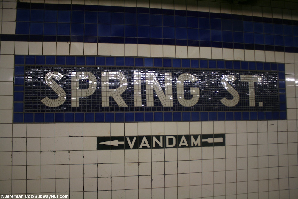
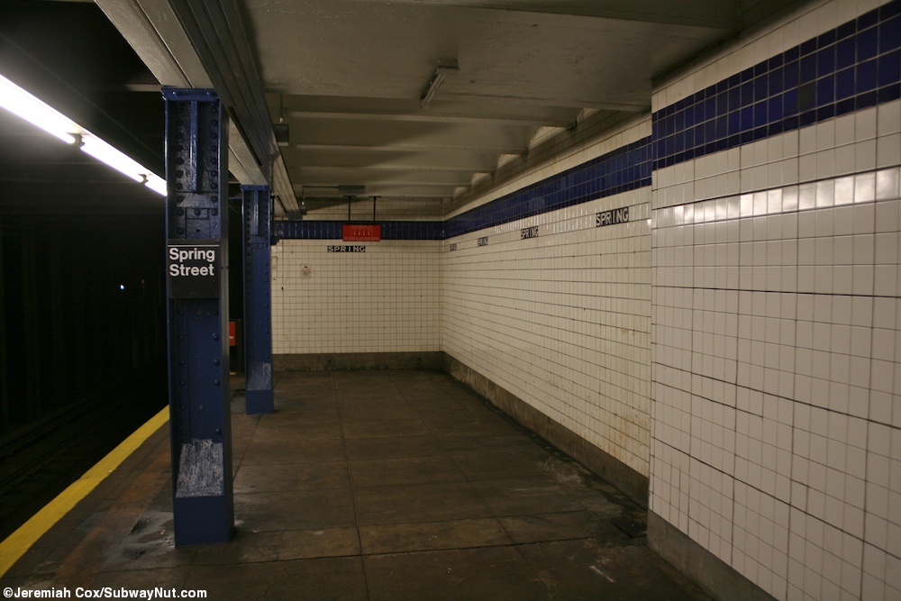
Wall tiling suggests that fare controls and a crossunder have been removed from the north end of the station. The platforms have a blue trim line on a dark blue border (ultramarine blue and cobalt blue, with replacement tiles at the north end that are ultramarine blue and navy blue). [29] The name tablets consist of "SPRING ST" in white sans-serif font on a dark blue background with a lighter blue border. Beneath the trim line and name tablets are "SPRING" and directional signs in white lettering on a black border tiled onto the walls. [30] Blue I-beam columns run along the entire length of both platforms, with every other one having the standard black and white station signs. [31]
Exits
All fare control areas are at platform level. The station's main ones are at the south end of the platform. Each contains banks of regular and HEET turnstiles, a token booth, and a single staircase going up to Spring Street and Sixth Avenue. The one on the northbound side is built inside the headquarters for God's Love We Deliver and leads to the northeast corner while the one on the southbound side leads to the northwest corner. [32] The southbound platform has an un-staffed HEET entrance that has a single staircase going up to the southwest corner of Vandam Street and Sixth Avenue. [32] There are also closed fare control areas at the north end of the station, which led to all four corners of the intersection of Prince Street/Charlton Street and Sixth Avenue. [28]
Artwork

In December 1984, Chilean artist Alfredo Jaar rented all the ad space in the station for the month, and put up an installation he called "Rushes", which showed 81 photos he had taken of poor Brazilian workers digging in Serra Pelada, a government-run gold mine. Scattered amongst them were signs giving world oil prices. [33] [34] [35]
The 1994 artwork installed at the stairway of the northbound platform's fare control is a large, lively mosaic called New York City Subway Station by Edith Kramer. [36] It consists of a single painting depicting 14th Street–Union Square on the IRT Lexington Avenue Line. [36]
References
- ^ "Glossary". Second Avenue Subway Supplemental Draft Environmental Impact Statement (SDEIS) (PDF). Vol. 1. Metropolitan Transportation Authority. March 4, 2003. pp. 1–2. Archived from the original (PDF) on February 26, 2021. Retrieved January 1, 2021.
- ^ "List of the 28 Stations on the New 8th Av. Line". The New York Times. September 10, 1932. p. 6. ISSN 0362-4331. Retrieved April 21, 2020.
- ^ "Annual Subway Ridership (2017–2022)". Metropolitan Transportation Authority. 2022. Retrieved November 8, 2023.
- ^ a b "Annual Subway Ridership (2017–2022)". Metropolitan Transportation Authority. 2022. Retrieved November 8, 2023.
- ^ "Two Subway Routes Adopted by City". The New York Times. August 4, 1923. p. 9. ISSN 0362-4331. Retrieved August 1, 2019.
- ^ "Plans Now Ready to Start Subways". The New York Times. March 12, 1924. p. 1. ISSN 0362-4331. Retrieved August 1, 2019.
- ^ a b "Hylan Subway Plan Links Four Boroughs at $450,000,000 Cost". The New York Times. December 10, 1924. p. 1. ISSN 0362-4331. Archived from the original on June 14, 2018. Retrieved June 29, 2018.
- ^ Raskin, Joseph B. (2013). The Routes Not Taken: A Trip Through New York City's Unbuilt Subway System. New York, New York: Fordham University Press. doi: 10.5422/fordham/9780823253692.001.0001. ISBN 978-0-82325-369-2.
- ^ a b "Express and Local Stations For New Eighth Avenue Line". New York Herald Tribune. February 5, 1928. p. B1. ISSN 1941-0646. ProQuest 1113431477.
- ^ Warner, Arthur (November 22, 1931). "The City's New Underground Province; The Eighth Avenue Subway Will Be Not Only a Transit Line but a Centre for the Shopper A New Underground Province of New York The Eighth Avenue Subway Will Be a Rapid Transit Line With Innovations and Will Provide Centres for the Shoppers". The New York Times. ISSN 0362-4331. Archived from the original on May 3, 2018. Retrieved May 2, 2018.
- ^ Daly, William Jerome (February 5, 1928). "New Subway Work Far Advanced, From the Circle to 207th Street: Small Section Near St. Nicholas Avenue and 148th Street Being Constructed". New York Herald Tribune. p. B1. ProQuest 1113431484.
- ^ Adams, Mildred (September 19, 1926). "Traffic Now Forces Huge Street Cutting; Sixth Avenue Extension to Focal Point on Canal, Street Is Perhaps the Most Extraordinary of Its Kind in the Entire History of New York City". The New York Times. ISSN 0362-4331. Retrieved May 15, 2018.
- ^ "Subway Wipes Out Landmarks In Lower Sixth Avenue Area". The New York Times. May 15, 1927. p. RE1. ISSN 0362-4331. ProQuest 104159892.
- ^ "Eighth Av. Subway Nearly Completed; Basic Construction Work From Chambers to 207th St. Done Except on Few Short Stretches". The New York Times. August 24, 1930. ISSN 0362-4331. Retrieved March 15, 2023.
- ^ O'Brien, John C. (September 9, 1931). "8th Ave. Line Being Rushed For Use Jan. 1: Turnstile Installation on Subway Begins Monday; Other Equipment Ready for Start of Train Service City Has Yet to Find Operating Company Transit Official on Trip, 207th to Canal Street, Inspects Finished Tube". New York Herald Tribune. p. 1. ISSN 1941-0646. ProQuest 1331181357.
- ^ "Sightseers Invade New Subway When Barricade Is lifted". The New York Times. September 9, 1932. ISSN 0362-4331. Archived from the original on July 1, 2022. Retrieved July 1, 2022.
- ^ "8th Av. Subway Gets First 5c. by Woman's Error: She Peers Into a Station, Hears Train, Pays for Ride, but Is Day Too Early Preparing for Tomorrow's Rush on 8th Ave. Subway". New York Herald Tribune. September 9, 1932. p. 1. ProQuest 1125436641.
- ^ Crowell, Paul (September 10, 1932). "Gay Midnight Crowd Rides First Trains In The New Subway: Throngs at Station an Hour Before Time, Rush Turnstiles When Chains are Dropped" (PDF). The New York Times. Retrieved November 8, 2015.
- ^ Sebring, Lewis B. (September 10, 1932). "Midnight Jam Opens City's New Subway: Turnstiles Click Into Action at 12:01 A. M. as Throngs Battle for Places in 'First' Trains Boy, 7, Leads Rush At 42d St. Station City at Last Hails 8th Ave. Line After 7-Year Wait; Cars Bigger, Clean Transit Commissioner Officially Opening New Subway at Midnight". New York Herald Tribune. p. 1. ISSN 1941-0646. ProQuest 1114839882.
- ^ "New Bronx Subway Starts Operation". The New York Times. July 1, 1933. p. 15. ISSN 0362-4331. Retrieved June 29, 2018.
- ^ Station Guide, Independent City Owned Rapid Transit Railroad (PDF) (Map). New York City Board of Transportation. c. 1937.
- ^ "Two Subway Units Open at Midnight". The New York Times. August 18, 1933. p. 17. ISSN 0362-4331. Retrieved June 29, 2018.
- ^ Bennett, Charles G. (November 20, 1949). "Transit Platforms on Lines in Queens to Be Lengthened; $3,850,000 Program Outlined for Next Year to Care for Borough's Rapid Growth". The New York Times. ISSN 0362-4331. Retrieved May 23, 2023.
- ^ "37 Platforms On Subways To Be Lengthened: All Stations of B. M. T. and I.R.T. in Queens Included in $5,000,000 Program". New York Herald Tribune. November 20, 1949. p. 32. ISSN 1941-0646. ProQuest 1325174459.
- ^ Report. New York City Transit Authority. 1953.
- ^ Ingalls, Leonard (August 28, 1953). "2 Subway Lines to Add Cars, Another to Speed Up Service" (PDF). The New York Times. ISSN 0362-4331. Retrieved January 25, 2016.
- ^ "16-Point Plan Can Give Boro Relief Now". Long Island Star–Journal. August 10, 1962. Retrieved April 24, 2018.
- ^ a b Review of the A and C Lines (PDF) (Report). Metropolitan Transportation Authority. December 11, 2015. Archived from the original (PDF) on February 3, 2020. Retrieved January 19, 2016.
- ^ "IND Station Tile Colors". www.nycsubway.org. Retrieved February 15, 2013.
- ^ Cox, Jeremiah (May 24, 2010). "A Spring St name tablet on the downtown platform with exit text to Vandam". subwaynut.com. Retrieved April 2, 2018.
- ^ Cox, Jeremiah (January 2, 2011). "The extreme northern end of the uptown platform tiling gets back to normal". subwaynut.com. Retrieved April 2, 2018.
- ^ a b "MTA Neighborhood Maps: SoHo / Tribeca" (PDF). Metropolitan Transportation Authority. 2015. Retrieved August 6, 2015.
-
^ Michael W. Brooks (1997).
Subway City: Riding the Trains, Reading New York. Rutgers University Press. p.
214.
ISBN
9780813523965. Retrieved February 14, 2013.
spring street ind station -atlanta.
- ^ Tracy Fitzpatrick (May 30, 2009). Art and the Subway: New York Underground. ISBN 9780813544526. Retrieved February 14, 2013.
- ^ "IN THE SUBWAYS; A Little Digging Yields Clues to the Revolution". Retrieved February 15, 2013.
- ^ a b "subway station art". Ephemeral New York. Retrieved February 15, 2013.
External links
- nycsubway.org – IND 8th Avenue: Spring Street
- nycsubway.org — New York Subway Station Artwork by Edith Kramer (1994)
- Station Reporter — C Train
- Station Reporter — E Train
- Spring Street entrance from Google Maps Street View
- Vandam Street entrance from Google Maps Street View
- Platform from Google Maps Street View