Spalding Power Plant and Dam | |
 Wheel house from the east | |
  | |
| Location | 10 County Rd., Spalding, Nebraska |
|---|---|
| Coordinates | 41°40′54″N 98°21′37″W / 41.68167°N 98.36028°W |
| Area | 58 acres (23 ha) |
| Built | 1919 |
| NRHP reference No. | 98001569 [1] |
| Added to NRHP | December 31, 1998 |
The Spalding Power Plant and Dam, at 10 County Rd. in Spalding in Greeley County, Nebraska, was built in 1919. It was listed on the National Register of Historic Places in 1998. [1]
The 58 acres (23 ha) site listed included two contributing buildings, a contributing structure, and two contributing sites. [1]
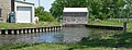
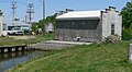
The buildings are one housing electrical generating engines and the wheel house which contains water powered turbines. The structure is the combination of the dam, its water race, and headgates. The sites are a golf course and a lake. [2]
Gallery
-
 Diversion dam on the Cedar River; from the south (downstream)
 -
 Diversion dam on the Cedar River; from the west
 -
 Diversion dam on the Cedar River; from the southwest (downstream)
 -
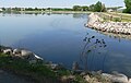 reservoir from downstream
 -
 Rail-mounted winch atop diversion dam
 -
 Rail-mounted winch atop diversion dam
 -
 Sluice gates from upstream
 -
 Sluice gates from downstream
 -
 Wheel house from upstream
 -
 Wheel house from west
 -
 Wheel house from southwest
 -
 Wheel house from southeast
 -
 Tailrace from upstream


References
- ^ a b c "National Register Information System". National Register of Historic Places. National Park Service. July 9, 2010.
- ^ Cora Esch (September 1998). "National Register of Historic Places Registration: Spalding Power Plant and Dam / GY00-163, GY00-164". National Park Service. Retrieved June 13, 2017. With four photos from 1998.
Categories:
- Historic districts on the National Register of Historic Places in Nebraska
- Buildings and structures completed in 1919
- National Register of Historic Places in Greeley County, Nebraska
- Dams in Nebraska
- Hydroelectric power plants in Nebraska
- Industrial buildings and structures on the National Register of Historic Places in Nebraska
- Nebraska Registered Historic Place stubs