Shoreham, New York | |
|---|---|
| Incorporated Village of Shoreham | |

Nikola Tesla's
Wardenclyffe Tower during construction in 1902 | |
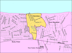
 U.S. Census map | |
| Coordinates: 40°57′25″N 72°54′31″W / 40.95694°N 72.90861°W | |
| Country | United States |
| State | New York |
| County | Suffolk |
| Incorporated | 1913 [1] |
| Area | |
| • Total | 0.45 sq mi (1.18 km2) |
| • Land | 0.45 sq mi (1.18 km2) |
| • Water | 0.00 sq mi (0.00 km2) |
| Elevation | 66 ft (20 m) |
| Population (
2020) | |
| • Total | 561 |
| • Density | 1,235.68/sq mi (477.06/km2) |
| Time zone | UTC-5:00 ( Eastern Time Zone) |
| • Summer ( DST) | UTC-4:00 |
| ZIP Code | 11786 |
| Area code(s) | 631, 934 |
| FIPS code | 36-67191 |
| GNIS feature ID | 0965160 |
| Website |
shorehamvillage |
Shoreham is an incorporated village in the Town of Brookhaven, Suffolk County, New York, United States. The population was 531 at the 2010 census. [3] It is officially known as the Incorporated Village of Shoreham.
History
In 1901, Nikola Tesla built a laboratory and began constructing the Wardenclyffe Tower at Shoreham, with the intent of using it to wirelessly transmit communications and electricity. [4] The tower was dismantled in 1917, and today a nearby static inverter plant receives electricity via the HVDC Cross Sound Cable. The nonprofit Tesla Science Center at Wardenclyffe is in the process of restoring Tesla's last remaining laboratory, building an educational center, and establishing a museum honoring his life and work on the property where the tower was once located. [5]
Shoreham was served by the Shoreham LIRR station from 1900 to 1910. It was located near the intersection of North Country Road and Randall Road.
Geography
Shoreham is located on the North Shore of Long Island, by Long Island Sound. It is approximately 100 km (70 miles) from New York City. According to the United States Census Bureau, the village has a total area of 0.4 square miles (1.0 km2), all land. Shoreham and the adjoining hamlet of East Shoreham share a post office, which has 11786 as the zip code. Despite its official name, Shoreham is invariably referred to by its inhabitants as "Shoreham Village", while East Shoreham is often called "Shoreham".
Demographics
| Census | Pop. | Note | %± |
|---|---|---|---|
| 1920 | 11 | — | |
| 1930 | 135 | 1,127.3% | |
| 1940 | 25 | −81.5% | |
| 1950 | 90 | 260.0% | |
| 1960 | 164 | 82.2% | |
| 1970 | 524 | 219.5% | |
| 1980 | 555 | 5.9% | |
| 1990 | 540 | −2.7% | |
| 2000 | 417 | −22.8% | |
| 2010 | 531 | 27.3% | |
| 2020 | 561 | 5.6% | |
| U.S. Decennial Census [6] | |||
As of the census [7] of 2000, there were 417 people, 145 households, and 126 families residing in the village. The population density was 938.3 inhabitants per square mile (362.3/km2). There were 163 housing units at an average density of 366.8 per square mile (141.6/km2). In 2010, the racial makeup of the village was 72.4% White, 12.6% Black or African American, 4.8% Asian, 0.9% Native American, and 0.2% Pacific Islander. 6.2% were of some other race, and 2.9% were of two or more races; Hispanics of any race comprised 16.3% of the population. [8]
There were 145 households, out of which 38.6% had children under the age of 18 living with them, 74.5% were married couples living together, 8.3% had a female householder with no husband present, and 13.1% were non-families. 11.0% of all households were made up of individuals, and 6.9% had someone living alone who was 65 years of age or older. The average household size was 2.88 and the average family size was 3.11.
In the village, the population was spread out, with 27.6% under the age of 18, 6.2% from 18 to 24, 17.7% from 25 to 44, 36.0% from 45 to 64, and 12.5% who were 65 years of age or older. The median age was 44 years. For every 100 females, there were 99.5 males. For every 100 females age 18 and over, there were 88.8 males.
The median income for a household in the village was $109,719, and the median income for a family was $116,985. Males had a median income of $81,873 versus $31,250 for females. The per capita income for the village was $37,620. None of the families and 1.4% of the population were living below the poverty threshold, including no under eighteens and none of those over 64.
Notable people
- D. B. Sweeney (born 1961), actor
- Carter Rubin (born 2005), singer, winner of season 19 of NBC's The Voice
References
- ^ "Village History". shorehamvillage.org. Retrieved July 21, 2021.
- ^ "ArcGIS REST Services Directory". United States Census Bureau. Retrieved September 20, 2022.
- ^ "Geographic Identifiers: 2010 Demographic Profile Data (G001): Shoreham village, New York". U.S. Census Bureau, American Factfinder. Archived from the original on February 12, 2020. Retrieved December 21, 2012.
- ^ "History of Wardenclyffe". Tesla Science Center at Wardenclyffe. Retrieved March 31, 2024.
- ^ "Mission". Tesla Science Center at Wardenclyffe. Retrieved December 27, 2013.
- ^ "Census of Population and Housing". Census.gov. Retrieved June 4, 2015.
- ^ "U.S. Census website". United States Census Bureau. Retrieved January 31, 2008.
- ^ "Profile of General Population and Housing Characteristics: 2010 more information 2010 Demographic Profile Data: Shoreham village, New York". United States Census Bureau. Retrieved October 22, 2013.

