Native name: 猿島 Nickname: Monkey Island | |
|---|---|
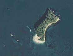
 Sarushima from the air | |
 Sarushima  Sarushima | |
| Geography | |
| Location | Yokosuka, Kanagawa |
| Coordinates | 35°17′10″N 139°41′39″E / 35.28611°N 139.69417°E |
| Area | 0.055 km2 (0.021 sq mi) |
| Coastline | 1.6 km (0.99 mi) |
| Highest elevation | 39.3 m (128.9 ft) |
| Administration | |
Japan | |
Sarushima (猿島, "Monkey Island"), is a small island located off Yokosuka, Kanagawa in Japan. It is the only natural island in Tokyo Bay. Sarushima was used as a battery by the Tokugawa shogunate during the Edo period, and after the Meiji Restoration in 1868, the island was developed as part of the Yokosuka Navy Yard. [1] [2]
Matthew C. Perry named the island Perry Island in 1853. [3]
Sarushima Park
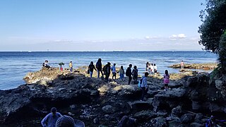
Sarushima is now uninhabited, and after World War II, it was developed as a marine park. Swimming and camping facilities were built on Sarushima, which makes it a popular fishing spot. The highest part of the island is still surrounded by a stone wall from the pre-war period, and features the remains of red brick barracks and a powder magazine. The island is accessible by a ferry. [1] [2]
Gallery
-
 On the ferry leaving the island
 -
 Southern Promentory
 -
 Southern Beach
 -
 From above
 -
 Inside the island
 -
 Fortified Pathway
 -
 Abandoned Watchtower
 -
 Bunker Tunnel
 -
 Gun Battery
 -
 Gun Battery Recess
 -
 Northwestern Overlook
 -
 Northern Cove


References
- ^ a b "猿島" [Sarushima]. Nihon Kokugo Daijiten (in Japanese). Tokyo: Shogakukan. 2012. OCLC 56431036. Archived from the original on 2007-08-25. Retrieved 2012-07-31.
- ^ a b "猿島" [Sarushima]. Nihon Daihyakka Zensho (Nipponika) (in Japanese). Tokyo: Shogakukan. 2012. OCLC 153301537. Archived from the original on 2007-08-25. Retrieved 2012-07-29.
- ^ "Matthew Calbraith Perry and Yokosuka" (PDF). Yokosuka. p. 9. Retrieved August 13, 2015.
External links
- Sarushima Island
- City of Yokosuka sightseeing information
- Sarushima: Welcome to Monkey Island CNN Travel article, April 2010