| Regal Mountain | |
|---|---|
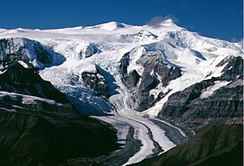
 Regal Mountain rises above the Regal Glacier | |
| Highest point | |
| Elevation | 13,845 ft (4,220 m) |
| Prominence | 4,345 ft (1,324 m) [1] |
| Isolation | 12 mi (19 km) |
| Listing | |
| Coordinates | 61°44′39″N 142°51′55″W / 61.74417°N 142.86528°W |
| Geography | |
| Location | Wrangell-St. Elias National Park and Preserve, Alaska, U.S. |
| Parent range | Wrangell Mountains |
| Topo map | USGS McCarthy C-5 |
| Geology | |
| Mountain type | Eroded stratovolcano or shield volcano |
| Climbing | |
| First ascent | August 3, 1964 by Yasuichi Kitamura, Ryoichi Hasegawa, Masao Tanaka, and Shinichi Naito [2] |
| Easiest route | Glacier climb |
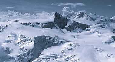
Regal Mountain is an eroded stratovolcano or shield volcano in the Wrangell Mountains of eastern Alaska. It is located in Wrangell-Saint Elias National Park about 19 mi (31 km) east of Mount Blackburn, the second highest volcano in the United States, and southeast of the massive Nabesna Glacier. Regal Mountain is the third highest thirteener (a peak between 13,000 and 13,999 feet in elevation) in Alaska, ranking just behind its neighbor, Atna Peaks. [1] Because the mountain is almost entirely covered in glaciers, no geological studies have been done, but published references state and the geological map shows that the mountain is an old eroded volcanic edifice.
Several major glaciers flow from the steep and heavily eroded flanks of Regal Mountain. The Rohn Glacier and Regal Glacier head east and southeast to join the Nizina Glacier, while the Root Glacier flows south 15 miles (24 km) to join the Kennicott Glacier just above the town of McCarthy. Each of those large glaciers exceeds 1 mile (1.6 km) in width, but largest of all on Regal Mountain is a massive unnamed glacier, over 3 miles (5 km) across, which flows northwest just over 10 mi (16 km) to join the mighty Nabesna.
See also

References
- Richter, Donald H.; Danny S. Rosenkrans; Margaret J. Steigerwald (1995). Guide to the Volcanoes of the Western Wrangell Mountains, Alaska. USGS Bulletin 2072.
- Winkler, Gary R. (2000). A Geologic Guide to Wrangell—Saint Elias National Park and Preserve, Alaska: A Tectonic Collage of Northbound Terranes. USGS Professional Paper 1616. ISBN 0-607-92676-7.
- Richter, Donald H.; Cindi C. Preller; Keith A. Labay; Nora B. Shew (2006). Geologic Map of the Wrangell-Saint Elias National Park and Preserve, Alaska. USGS Scientific Investigations Map 2877.
- ^ a b "Alaska 13,000-foot Peaks". Peakbagger.com. Retrieved 2007-03-10.
- ^ "Alaska's Summits 13,000 feet and above". Archived from the original on June 30, 2006. Retrieved 2007-03-10.
External links
- Shield volcanoes of the United States
- Stratovolcanoes of the United States
- Subduction volcanoes
- Landforms of Copper River Census Area, Alaska
- Volcanoes of Alaska
- Mountains of Alaska
- Wrangell–St. Elias National Park and Preserve
- North American 4000 m summits
- Mountains of Unorganized Borough, Alaska
- Volcanoes of Unorganized Borough, Alaska
