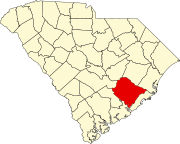
Pringletown, South Carolina | |
|---|---|
| Coordinates: 33°08′38″N 80°18′21″W / 33.14389°N 80.30583°W | |
| Country | United States |
| State | South Carolina |
| County | Berkeley |
| Named for | Pringle family |
| Elevation | 56 ft (17 m) |
| Time zone | UTC-5 ( Eastern (EST)) |
| • Summer ( DST) | UTC-4 (EDT) |
| ZIP code | 29472
[1] |
| Area code | 843 and 854 |
| GNIS feature ID | 1250248 [2] |
Pringletown is an unincorporated community in Berkeley County, South Carolina, United States. It is located along Old Gilliard Road ( SC 27), north of Interstate 26 (exit 187). Formally spelled "Pringle Town," the community was named after the Pringle family, which lived in the area. [3]
The community is the closest populated place to both the MacDougall Correctional Institution, located north along Old Gilliard Road, and the Volvo Cars - South Carolina Factory, located east via Autonomous Drive.
References
- ^ "USPS Carrier Route Maps". Melissa Lookups. Archived from the original on April 18, 2021. Retrieved April 18, 2021.
- ^ "Pringletown, South Carolina". Geographic Names Information System. United States Geological Survey, United States Department of the Interior. Retrieved April 18, 2021.
- ^ Neuffer, Claude Henry; Neuffer, Irene (1967). Claude and Irene Neuffer's Names in South Carolina Vols. XIII-XVIII, 1966-1971. South Carolina: The Reprint Company. p. 31. ISBN 9780871523914. Retrieved April 18, 2021.


