Selected articles list
Portal:California/Selected article/1

The Mono–Inyo Craters are a volcanic chain of craters, domes and lava flows in Mono County, Eastern California. The chain stretches 25 miles (40 km) from the northwest shore of Mono Lake to the south of Mammoth Mountain. The Mono Lake Volcanic Field forms the northernmost part of the chain and consists of two volcanic islands in the lake and one cinder cone volcano on its northwest shore. Most of the Mono Craters, which make up the bulk of the northern part of the Mono–Inyo chain, are phreatic (steam explosion) volcanoes that have since been either plugged or over-topped by rhyolite domes and lava flows. The Inyo volcanic chain form much of the southern part of the chain and consist of phreatic explosion pits, and rhyolitic lava flows and domes. The southernmost part of the chain consists of fumaroles and explosion pits on Mammoth Mountain and a set of cinder cones south of the mountain; the latter are called the Red Cones.
The region has been used by humans for centuries. Obsidian was collected by Mono Paiutes for making sharp tools and arrow points. Glassy rock continues to be removed in modern times for use as commercial scour and yard decoration. Mono Mills processed timber felled on or near the volcanoes for the nearby boomtown Bodie in the late 19th to early 20th centuries. Water diversions into the Los Angeles Aqueduct system from their natural outlets in Mono Lake started in 1941 after a water tunnel was cut under the Mono Craters. Mono Lake Volcanic Field and a large part of the Mono Craters gained some protection under Mono Basin National Forest Scenic Area in 1984. Resource use along all of the chain is managed by the United States Forest Service as part of Inyo National Forest. Various activities are possible along the chain, including hiking, bird watching, canoeing, skiing, and mountain biking. ( Full article...)
Portal:California/Selected article/2

Portal:California/Selected article/3

Portal:California/Selected article/4

Death Valley National Park is an American national park that straddles the California– Nevada border, east of the Sierra Nevada. The park boundaries include Death Valley, the northern section of Panamint Valley, the southern section of Eureka Valley and most of Saline Valley. ( Full article...)
Portal:California/Selected article/5

Rancho San Francisco was a land grant in present-day northwestern Los Angeles County and eastern Ventura County, California. It was a grant of 48,612 acres (19,673 ha) by Governor Juan B. Alvarado to Antonio del Valle, a Mexican army officer, in recognition for his service to Alta California. It is not related to the city of San Francisco.
The rancho is the location of the first popularly known finding of gold in the Southern California area in 1842, in Placerita Canyon. Much of the present day city of Santa Clarita lies within the boundary of what was Rancho San Francisco. The adobe headquarters of the rancho, and the site of the gold find (known today as the "Oak of the Golden Dream"), are designated California Historical Landmarks. The rancho included portions of the San Gabriel, Santa Susana, Topatopa, and Sierra Pelona Mountain ranges. ( Full article...)
Portal:California/Selected article/6

It is a large, black vulture with patches of white on the underside of the wings and a largely bald head with skin color ranging from yellowish to a bright red, depending on the bird's mood. It has the largest wingspan of any bird found in North America and is one of the heaviest. The condor is a scavenger and eats large amounts of carrion. It is one of the world's longest-living birds, with a lifespan of up to 50 years. Condor numbers dramatically declined in the 19th century due to poaching, lead poisoning, and habitat destruction. Eventually, a conservation plan was put in place by the United States government that led to the capture of all the remaining wild condors in 1987. These 22 birds were bred at the San Diego Wild Animal Park and the Los Angeles Zoo. ( Full article...)
Portal:California/Selected article/7
.jpg)
In 1904, the Welsh Revival took place, during which approximately 100,000 people in Wales converted to Christianity. Internationally, Evangelical Christians took this event to be a sign that a fulfillment of the prophecy in the Bible's book of Joel, chapter 2:23–29 was about to take place. Joseph Smale, pastor of the First Baptist Church in Los Angeles, went to Wales personally in order to witness the revival. ( Full article...)
Portal:California/Selected article/8

The Winfield Scott has been the object of numerous salvage operations since the crash, and currently rests underwater as part of the Channel Islands National Park and Marine Sanctuary. The wreck site of the Winfield Scott is listed on the National Register of Historic Places. The discovery of gold at Sutter's Mill in 1848 brought thousands of people to California in search of fortune until the late 1850s. Since neither the Panama Canal nor the First Transcontinental Railroad had been constructed, people emigrating to California from the Eastern United States had three main routes of passage. They could travel over land, which was expensive and dangerous, or they could sail the roughly 14,000-mile route around South America. This was more attractive to some but no less dangerous, due in part to the rough waters of the Drake Passage. In addition to the inherent dangers of either route, the journey often took as long as six months to complete. ( Full article...)
Portal:California/Selected article/9

Temple Sinai (officially the First Hebrew Congregation of Oakland) is a Reform Jewish congregation and synagogue located at 2808 Summit Street (28th and Webster Streets) in Oakland, California, in the United States. Founded in 1875, it is the oldest Jewish congregation in the East San Francisco Bay region.
Its early members included Gertrude Stein and Judah Leon Magnes, who studied at Temple Sinai's Sabbath school, and Ray Frank, who taught them. Originally traditional, the temple reformed its beliefs and practices under the leadership of Rabbi Marcus Friedlander (1893–1915). By 1914, it had become a Classical Reform congregation. That year the current sanctuary was built: a Beaux-Arts structure designed by G. Albert Lansburgh, which is the oldest synagogue building in Oakland. ( Full article...)
Portal:California/Selected article/10

The Fairfield Osborn Preserve is a 450-acre nature reserve situated on the northwest flank of Sonoma Mountain in Sonoma County, California. There are eight plant communities within the property, oak woodland being the dominant type. Other communities include chaparral, Douglas fir woodland, native Bunch grass, freshwater marsh, vernal pool, pond and riparian woodland. The flora is extremely diverse including many native trees, shrubs, wildflowers, grasses, lichens and mosses. A diverse fauna inhabits this area including black-tailed deer, coyote, bobcat and an occasional mountain lion; moreover, there are abundant avifauna (including some neotropical migrants), amphibians, reptiles and insects.
Copeland Creek and its tributaries drain the Preserve as they wend their way down steep ravines toward eventual discharge to the Laguna de Santa Rosa. The property was originally a Spanish Land Grant holding, devolving to private ownership and eventually given to The Nature Conservancy; the preserve is now owned and managed by Sonoma State University as a research and education site. An understated natural trail system weaves through the property to provide access to creek canyons, ridges and marshy areas. The preserve is situated at elevations 1,350 to 2,300 feet (411 to 701 meters) above sea level and features a landscape riddled with basalt exposures that betray the volcanic prehistory of Sonoma County. The climate at the Preserve is mild, with most rainfall occurring in the winter months and with some influence of the Pacific Ocean providing moderating temperatures and some marine fog on early summer mornings. ( Full article...)
Portal:California/Selected article/11 State Route 160 (SR 160) is a state highway in the U.S. state of California consisting of two sections. The longer, southern, section is a scenic highway through the alluvial plain of the Sacramento River, linking SR 4 in Antioch with Sacramento via the Antioch Bridge. The northern section, separated from the southern by Sacramento city streets, is the North Sacramento Freeway, running from the 16th Street Bridge over the American River to Interstate 80 Business towards Roseville.
This northern section was deleted from the definition in the Streets and Highways Code in 2003, when the relinquished portion through downtown Sacramento was also removed, but it is still maintained and signed by the California Department of Transportation (Caltrans) as SR 160. ( Full article...)
Portal:California/Selected article/12

The Red Hot Chili Peppers are an American rock band formed in Los Angeles in 1982, comprising vocalist Anthony Kiedis, bassist Flea, drummer Chad Smith, and guitarist John Frusciante. Their music incorporates elements of alternative rock, funk, punk rock, hard rock, hip hop, and psychedelic rock. Their eclectic range has influenced genres such as funk metal, rap metal, rap rock, and nu metal. With over 120 million records sold worldwide, the Red Hot Chili Peppers are one of the top-selling bands of all time. They hold the records for most number-one singles (15), most cumulative weeks at number one (91) and most top-ten songs (28) on the Billboard Alternative Songs chart. They have won six Grammy Awards, were inducted into the Rock and Roll Hall of Fame in 2012, and in 2022 received a star on the Hollywood Walk of Fame.
The Red Hot Chili Peppers were formed in Los Angeles by Kiedis, Flea, guitarist Hillel Slovak and drummer Jack Irons. Due to commitments to other bands, Slovak and Irons did not play on the band's 1984 self-titled debut album, which instead featured guitarist Jack Sherman and drummer Cliff Martinez. Slovak rejoined for their second album, Freaky Styley (1985), and Irons for their third, The Uplift Mofo Party Plan (1987). Irons left after Slovak died of a drug overdose in June 1988. ( Full article...)
Portal:California/Selected article/13
The University of California, Riverside (UCR or UC Riverside) is a public land-grant research university in Riverside, California. It is one of the ten campuses of the University of California system. The main campus sits on 1,900 acres (769 ha) in a suburban district of Riverside with a branch campus of 20 acres (8 ha) in Palm Desert. In 1907, the predecessor to UCR was founded as the UC Citrus Experiment Station, Riverside which pioneered research in biological pest control and the use of growth regulators.
UCR's undergraduate College of Letters and Science opened in 1954. The Regents of the University of California declared UCR a general campus of the system in 1959, and graduate students were admitted in 1961. To accommodate an enrollment of 21,000 students by 2015, more than $730 million has been invested in new construction projects since 1999.[ needs update] Preliminary accreditation of the UC Riverside School of Medicine was granted in October 2012 and the first class of 50 students was enrolled in August 2013. It is the first new research-based public medical school in 40 years. UCR is a member of the Association of American Universities. ( Full article...)
Portal:California/Selected article/14

The Beach Boys are an American rock band formed in Hawthorne, California, in 1961. The group's original lineup consisted of brothers Brian, Dennis, and Carl Wilson, their cousin Mike Love, and friend Al Jardine. Distinguished by their vocal harmonies, adolescent-oriented lyrics, and musical ingenuity, they are one of the most influential acts of the rock era. They drew on the music of older pop vocal groups, 1950s rock and roll, and black R&B to create their unique sound. Under Brian's direction, they often incorporated classical or jazz elements and unconventional recording techniques in innovative ways.
The Beach Boys are one of the most critically acclaimed and commercially successful bands of all time, selling over 100 million records worldwide. They helped legitimize popular music as a recognized art form and influenced the development of music genres and movements such as psychedelia, power pop, progressive rock, punk, alternative, and lo-fi. Between the 1960s and 2020s, the group had 37 songs reach the US Top 40 (the most by an American band), with four topping the Billboard Hot 100. In 2004, they were ranked number 12 on Rolling Stone's list of the greatest artists of all time. Many critics' polls have ranked Today!, Pet Sounds, Smiley Smile (1967), Sunflower (1970), and Surf's Up (1971) among the finest albums in history. The founding members were inducted into the Rock and Roll Hall of Fame in 1988. Other members during the band's history have been David Marks, Bruce Johnston, Blondie Chaplin, and Ricky Fataar. ( Full article...)
Portal:California/Selected article/15

The land on which the observatory stands was donated to the City of Los Angeles by Col. Griffith J. Griffith in 1896. In his will, Griffith donated funds to build an observatory, exhibit hall, and planetarium on the donated land. Construction began on June 20, 1933 using a design developed by architect John C. Austin based on preliminary sketches by Russell W. Porter. The observatory and accompanying exhibits were opened to the public on May 14, 1935. ( Full article...)
Portal:California/Selected article/16

Hearst Castle was built on a 40,000 acre (160 km²) ranch that William Randolph Hearst's father, George Hearst, originally purchased in 1865. The younger Hearst grew fond of this site over many childhood family camping trips. He inherited the ranch, which had grown to 250,000 acres (1000 km²), from his mother, Phoebe Apperson Hearst, upon her death in 1919. Construction began that same year and continued through 1947, when he stopped living at the estate due to ill health. San Francisco architect Julia Morgan designed most of the buildings. Hearst was an inveterate tinkerer, and would tear down structures and rebuild them at a whim, so the estate was never completed in his lifetime. ( Full article...)
Portal:California/Selected article/17

The Coalinga earthquake was caused by an 0.5-meter uplift of the anticline ridge northeast of Coalinga, but surface faulting was not observed. Ground and aerial searches immediately after the earthquake revealed ground cracks and fissures within about 10 kilometers of the instrumental epicenter, none of which appeared to represent movement on deeply rooted fault structures. About five weeks later, on June 11, however, an aftershock caused surface faulting about 12 kilometers northwest of Coalinga. ( Full article...)
Portal:California/Selected article/18

The Dakin building has won a number of architectural awards including an American Institute of Architects Design Excellence Award in the year 1992. According to the San Francisco Examiner the jury awarded this distinction to the Dakin building because "Its chief strength is the atrium, with its views of the San Francisco Bay and asymmetrical skylight". The same newspaper article noted that the building "houses executive offices, research and development facilities and product showrooms." ( Full article...)
Portal:California/Selected article/19

Ebell of Los Angeles was formed as a women's club in 1894, based on the principles and teachings of Adrian Ebell, a pioneer in women's education and organizing women's societies in the late 19th century. The minutes of the first meeting of Ebell of Los Angeles identify its purpose "to interest women in the study of all branches of literature, art and science and the advancement of women in every branch of culture." The club adopted as its motto, "I will find a way or make one -- I serve." ( Full article...)
Portal:California/Selected article/20

The original Islais Creek stretched from the San Francisco Bay 3.5 miles (5.6 km) west into the Glen Canyon Park and O’Shaughnessy Hollow. The creek, once the largest body of water within San Francisco covering an area of 5,000 acres (7.813 sq mi; 20.234 km2), had two branches. One branch originated near the southern slope of Twin Peaks, formerly known as San Miguel Hills, slightly north of today's Portola Drive. It then coursed through Glen Canyon and through what is now Bosworth Street until it reached the bottom of the Mission Street viaduct at I-280. The other branch began at the Cayuga Avenue and Regent Street intersection. The creek flowed from the intersection down to the Mission Street viaduct where the two branches joined. ( Full article...)
Portal:California/Selected article/21

As a polytechnic university, Cal Poly Pomona maintains strong science and engineering departments. The university's engineering program. Cal Poly Pomona is a member of the American Association of State Colleges and Universities (AASCU) and a "University of Excellence" according to the National Association of State Universities and Land-Grant Colleges. ( Full article...)
Portal:California/Selected article/22

Portal:California/Selected article/23

Yosemite National Park ( /joʊˈsɛmɪti/ yoh-SEM-ih-tee) is a national park in California. It is bordered on the southeast by Sierra National Forest and on the northwest by Stanislaus National Forest. The park is managed by the National Park Service and covers 759,620 acres (1,187 sq mi; 3,074 km2) in four counties – centered in Tuolumne and Mariposa, extending north and east to Mono and south to Madera. Designated a World Heritage Site in 1984, Yosemite is internationally recognized for its granite cliffs, waterfalls, clear streams, giant sequoia groves, lakes, mountains, meadows, glaciers, and biological diversity. Almost 95 percent of the park is designated wilderness. Yosemite is one of the largest and least fragmented habitat blocks in the Sierra Nevada. ( Full article...)
Portal:California/Selected article/24

Portal:California/Selected article/25

The Port Chicago disaster was a deadly munitions explosion of the ship SS E. A. Bryan on July 17, 1944, at the Port Chicago Naval Magazine in Port Chicago, California, United States. Munitions being loaded onto a cargo vessel bound for the Pacific Theater of Operations detonated killing 320 sailors and civilians and injuring 390 others.
A month later, the unsafe conditions prompted hundreds of servicemen to refuse to load munitions, an act known as the Port Chicago Mutiny. Fifty men—called the "Port Chicago 50"—were convicted of mutiny and sentenced to 15 years of prison and hard labor, as well as a dishonorable discharge. Forty-seven of the 50 were released in January 1946; the remaining three served additional months in prison. ( Full article...)
Portal:California/Selected article/26

The exposed geology of the Death Valley area presents a diverse and complex set of at least 23 formations of sedimentary units, two major gaps in the geologic record called unconformities, and at least one distinct set of related formations geologists call a group. The oldest rocks in the area that now includes Death Valley National Park are extensively metamorphosed by intense heat and pressure and are at least 1700 million years old. These rocks were intruded by a mass of granite 1400 Ma (million years ago) and later uplifted and exposed to nearly 500 million years of erosion.
Marine deposition occurred 1200 to 800 Ma, forming thick sequences of conglomerate, mudstone, and carbonate rock topped by stromatolites, and possibly glacial deposits from the hypothesized Snowball Earth event. Rifting thinned huge roughly linear parts of the supercontinent Rodinia enough to allow sea water to invade and divide its landmass into component continents separated by narrow straits. A passive margin developed on the edges of these new seas in the Death Valley region. Carbonate banks formed on this part of the two margins only to be subsided as the continental crust thinned until it broke, giving birth to a new ocean basin. An accretion wedge of clastic sediment then started to accumulate at the base of the submerged precipice, entombing the region's first known fossils of complex life. These sandy mudflats gave way about 550 Ma to a carbonate platform which lasted for the next 300 million years of Paleozoic time. ( Full article...)
Portal:California/Selected article/27

Manzanar is the site of one of ten American concentration camps, where more than 120,000 Japanese Americans were incarcerated during World War II from March 1942 to November 1945. Although it had over 10,000 inmates at its peak, it was one of the smaller internment camps. It is located at the foot of the Sierra Nevada mountains in California's Owens Valley, between the towns of Lone Pine to the south and Independence to the north, approximately 230 miles (370 km) north of Los Angeles. Manzanar means "apple orchard" in Spanish. The Manzanar National Historic Site, which preserves and interprets the legacy of Japanese American incarceration in the United States, was identified by the United States National Park Service as the best-preserved of the ten former camp sites.
The first Japanese Americans arrived at Manzanar in March 1942, just one month after President Franklin D. Roosevelt signed Executive Order 9066, to build the camp their families would be staying in. Manzanar was in operation as an internment camp from 1942 until 1945. Since the last of those incarcerated left in 1945, former detainees and others have worked to protect Manzanar and to establish it as a National Historic Site to ensure that the history of the site, along with the stories of those who were incarcerated there, is recorded for current and future generations. The primary focus is the Japanese American incarceration era, as specified in the legislation that created the Manzanar National Historic Site. The site also interprets the former town of Manzanar, the ranch days, the settlement by the Owens Valley Paiute, and the role that water played in shaping the history of the Owens Valley. ( Full article...)
Portal:California/Selected article/28 Odwalla Inc. ( /oʊˈdwɔːlə/) is an American health food company based in Dinuba, California. Founded in Santa Cruz, California in 1980 and formerly headquartered in Half Moon Bay, California from 1995 to 2020, the company's product lines include fruit juices, smoothies, soy milk, bottled water, organic beverages, and several types of energy bars known as "food bars".
The company experienced strong growth after its incorporation in 1985, expanding its distribution network from California to most of North America, and went public in 1993.
In 2001, Odwalla was acquired by The Coca-Cola Company for US$181 million and became a wholly owned subsidiary. In July 2020, Coca-Cola announced it would discontinue the Odwalla brand by August 2020. The brand was sold to Full Sail IP Partners in 2021. Its headquarters was relocated to its production facility some time in the early 2020s. ( Full article...)
Portal:California/Selected article/29
.png)
The California Diamond Jubilee half dollar was a United States commemorative silver fifty-cent piece struck at the San Francisco Mint in 1925. It was issued to celebrate the 75th anniversary of California statehood.
The San Francisco Citizens' Committee wished to issue a commemorative coin as a fundraiser for a celebration of the statehood diamond jubilee. A California congressman attached authorization for it to another coinage bill, which was approved by Congress in early 1925. Designs by sculptor Jo Mora met a hostile reception at the Commission of Fine Arts, but the Citizens' Committee would not change them, and they were approved. The coin has been widely praised for its beauty in the years since. ( Full article...)
Portal:California/Selected article/30

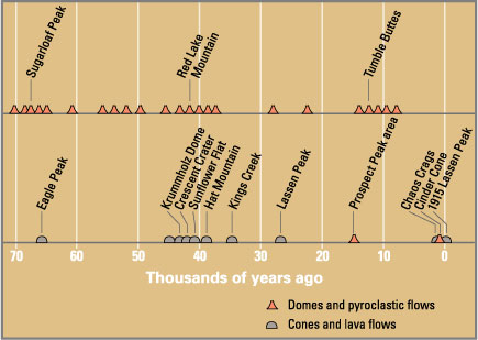
The Lassen volcanic area presents a geological record of sedimentation and volcanic activity in and around Lassen Volcanic National Park in Northern California, U.S. The park is located in the southernmost part of the Cascade Mountain Range in the Pacific Northwest region of the United States. Pacific Oceanic tectonic plates have plunged below the North American Plate in this part of North America for hundreds of millions of years. Heat and molten rock from these subducting plates has fed scores of volcanoes in California, Oregon, Washington and British Columbia over at least the past 30 million years, including these in the Lassen volcanic areas.
Between 3 and 4 million years ago, volcanic-derived mud flows called lahars streamed down several major mountains that included nearby but now extinct Mount Yana and Mount Maidu to become the Tuscan Formation. Basaltic and later andesitic to dacitic flows of lava covered increasingly larger areas of this formation to eventually form the lava plateau upon which the park is situated. About 600,000 years ago, Mount Tehama started to rise as a stratovolcano in the southwestern corner of the park, eventually reaching an estimated 11,000 ft (3,400 m) in height. ( Full article...)
Portal:California/Selected article/31

The Daily News (originally the Illustrated Daily News) was a newspaper published in Los Angeles from 1923 to 1954. It was founded in 1923 by Cornelius Vanderbilt IV and bought by Manchester Boddy who operated it through most of its existence.
The Daily News was founded in 1923 by Vanderbilt as the first of several newspapers he wanted to manage. After quickly going into receivership, it was sold to Boddy, a businessman with no newspaper experience. Boddy was able to make the newspaper succeed, and it remained profitable through the 1930s and 1940s, taking a Democratic perspective at a time when most Los Angeles newspapers supported the Republican Party. ( Full article...)
Portal:California/Selected article/32
The Carolwood Pacific Railroad (CPRR) was a 7+1⁄4-inch (184 mm) gauge ridable miniature railroad run by Walt Disney in the backyard of his home in the Holmby Hills neighborhood of Los Angeles, California. It featured the Lilly Belle, a 1:8- scale live steam locomotive named after Disney's wife, Lillian Disney, and built by the Walt Disney Studios' machine shop. The locomotive made its first test run on December 24, 1949. It pulled a set of freight cars, as well as a caboose that was almost entirely built by Disney himself. It was Disney's lifelong fascination with trains, as well as his interest in miniature models, that led to the creation of the CPRR. The railroad, which became operational in 1950, was 2,615 feet (797 m) long and encircled his house. The backyard railroad attracted visitors to Disney's home; he invited them to ride and occasionally drive his miniature train. In 1953, after an accident occurred in which a guest was injured, the CPRR was closed to the public.
The Carolwood Pacific Railroad inspired Disney to include railroad attractions in the design for the Disneyland theme park in Anaheim, California. Railroad attractions in Disney theme parks around the world are now commonplace. The barn structure that was used as the railroad's control center is now at the Los Angeles Live Steamers Railroad Museum in Los Angeles' Griffith Park. The Lilly Belle, some of the freight cars, and the caboose are now on display at the Walt Disney Family Museum in San Francisco, California. ( Full article...)
Portal:California/Selected article/33

San Francisco, officially the City and County of San Francisco, is a commercial, financial, and cultural center in Northern California. With a population of 808,437 residents as of 2022, San Francisco is the fourth most populous city in the U.S. state of California. The city covers a land area of 46.9 square miles (121 square kilometers) at the end of the San Francisco Peninsula, making it the second-most densely populated large U.S. city after New York City and the fifth-most densely populated U.S. county, behind only four New York City boroughs. Among the 92 U.S. cities proper with over 250,000 residents, San Francisco was ranked first by per capita income and sixth by aggregate income . Colloquial nicknames for San Francisco include Frisco, San Fran, The City, and SF (although San Fran is generally not used by locals).
Prior to European settlement, the modern city proper was inhabited by the Yelamu, who spoke a language now referred to as Ramaytush Ohlone. On June 29, 1776, settlers from New Spain established the Presidio of San Francisco at the Golden Gate, and the Mission San Francisco de Asís a few miles away, both named for Francis of Assisi. The California gold rush of 1849 brought rapid growth, transforming an unimportant hamlet into a busy port, making it the largest city on the West Coast at the time; between 1870 and 1900, approximately one quarter of California's population resided in the city proper. In 1856, San Francisco became a consolidated city-county. After three-quarters of the city was destroyed by the 1906 earthquake and fire, it was quickly rebuilt, hosting the Panama–Pacific International Exposition nine years later. In World War II, it was a major port of embarkation for naval service members shipping out to the Pacific Theater. In 1945, the United Nations Charter was signed in San Francisco, establishing the United Nations and in 1951, the Treaty of San Francisco re-established peaceful relations between Japan and the Allied Powers. After the war, the confluence of returning servicemen, significant immigration, liberalizing attitudes, the rise of the beatnik and hippie countercultures, the sexual revolution, the peace movement growing from opposition to United States involvement in the Vietnam War, and other factors led to the Summer of Love and the gay rights movement, cementing San Francisco as a center of liberal activism in the United States. ( Full article...)
Portal:California/Selected article/34
Amador Valley High School is a comprehensive public high school in Pleasanton, California. It is one of three high schools in the Pleasanton Unified School District, along with Foothill High School and Village High School.
Founded as Amador Valley Joint Union High School (AVJUHS), it graduated its first class in 1923. Major construction and renovations were undertaken after district voters approved bonds in 1922, 1965, 1997, and 2016. ( Full article...)
Portal:California/Selected article/35

Metallica is an American heavy metal band. The band was formed in 1981 in Los Angeles by vocalist and guitarist James Hetfield and drummer Lars Ulrich, and has been based in San Francisco for most of its career. The band's fast tempos, instrumentals and aggressive musicianship made them one of the founding "big four" bands of thrash metal, alongside Megadeth, Anthrax and Slayer. Metallica's current lineup comprises founding members and primary songwriters Hetfield and Ulrich, longtime lead guitarist Kirk Hammett and bassist Robert Trujillo. Guitarist Dave Mustaine, who formed Megadeth after being fired from Metallica, and bassists Ron McGovney, Cliff Burton and Jason Newsted are former members of the band.
Metallica first found commercial success with the release of its third album, Master of Puppets (1986), which is cited as one of the heaviest metal albums and the band's best work. The band's next album, ...And Justice for All (1988), gave Metallica its first Grammy Award nomination. Its fifth album, Metallica (1991), was a turning point for the band that saw them transition from their thrash roots; it appealed to a more mainstream audience, achieving substantial commercial success and selling more than 16 million copies in the United States to date, making it the best-selling album of the SoundScan era. After experimenting with different genres and directions in subsequent releases, Metallica returned to its thrash metal roots with its ninth album, Death Magnetic (2008), which drew similar praise to that of the band's earlier albums. The band's eleventh and most recent album, 72 Seasons, was released in 2023. ( Full article...)
Portal:California/Selected article/36

The 2018 United States Senate election in California took place on November 6, 2018, to elect a member of the United States Senate to represent California, concurrently with other elections to the United States Senate, elections to the United States House of Representatives, and various state and local elections.
Under California's non-partisan blanket primary law, all candidates appear on the same ballot, regardless of party. In the primary, voters may vote for any candidate, regardless of their party affiliation. In the California system, the top two finishers — regardless of party — advance to the general election in November, even if a candidate receives a majority of the votes cast in the primary election. Washington and Louisiana have similar " jungle primary" style processes for U.S. Senate elections, as does Mississippi for U.S. Senate special elections. ( Full article...)
Portal:California/Selected article/37
.jpg)
The 2020 United States presidential election in California was held on Tuesday, November 3, 2020, as part of the 2020 United States presidential election in which all 50 states plus the District of Columbia participated. California voters chose electors to represent them in the Electoral College via a popular vote, pitting the Republican Party's nominee, incumbent President Donald Trump, and running mate Vice President Mike Pence against Democratic Party nominee, former Vice President Joe Biden, and his running mate Kamala Harris, the junior senator from California. California had, in the 2020 election 55 electoral votes in the Electoral College, the most of any state. California was one of six states where Trump received more percentage of the two-party vote than he did in 2016. This election also marked the first time since 2004 that the Republican candidate won more than one million votes in Los Angeles County, due to increased turnout statewide.
California is considered a safe blue state in presidential elections, due to significant concentrations of Democratic voters in large urban regions such as the San Francisco Bay Area, Sacramento, Los Angeles, and San Diego. As predicted, Biden easily carried California on election day, earning 63.5% of the vote and a margin of 29.2% over Trump. Biden earned the highest percentage of the vote in the state for any candidate since Franklin D. Roosevelt in 1936, although Biden's margin of victory was slightly smaller than Hillary Clinton's 30.1% in 2016, making it one of just six states in which Trump improved on his 2016 margin. Biden became the first candidate in any race for any office in U.S. history to win more than 10 million votes in a single state, while Trump also received the most votes a Republican has ever received in any state in any race since the country's founding, even narrowly besting his vote total in Texas, a state that he won. Biden's vote margin was the largest vote margin for a presidential candidate in a singular state. ( Full article...)
Portal:California/Selected article/38

The Ohlone ( /oʊˈloʊni/ oh-LOH-nee), formerly known as Costanoans (from Spanish costeño meaning 'coast dweller'), are a Native American people of the Northern California coast. When Spanish explorers and missionaries arrived in the late 18th century, the Ohlone inhabited the area along the coast from San Francisco Bay through Monterey Bay to the lower Salinas Valley. At that time they spoke a variety of related languages. The Ohlone languages make up a sub-family of the Utian language family. Older proposals place Utian within the Penutian language phylum, while newer proposals group it as Yok-Utian.
In pre-colonial times, the Ohlone lived in more than 50 distinct landholding groups, and did not view themselves as a single unified group. They lived by hunting, fishing, and gathering, in the typical ethnographic California pattern. The members of these various bands interacted freely with one another. The Ohlone people practiced the Kuksu religion. Prior to the Gold Rush, the northern California region was one of the most densely populated regions north of Mexico. ( Full article...)
Portal:California/Selected article/39

The University of California, Berkeley (UC Berkeley, Berkeley, Cal, or California) is a public land-grant research university in Berkeley, California. Founded in 1868 and named after Anglo-Irish philosopher George Berkeley, it is the state's first land-grant university and the founding campus of the University of California system. Berkeley is also a founding member of the Association of American Universities. It has been regarded as one of the top universities in the world.
Berkeley is classified among "R1: Doctoral Universities—Very high research activity" and has three national laboratories for the U.S. Department of Energy ( Lawrence Berkeley National Laboratory, Lawrence Livermore National Laboratory, and Los Alamos National Laboratory). Between 2001 and 2010, it was the No. 1 recipient of National Science Foundation Graduate Research Fellowships with 1,333 awards. In 2021, the funding for research and development exceeded $1 billion. Thirty-two libraries compose the Berkeley library system which is the sixth largest research library by number of volumes in the United States. Berkeley's athletic teams, the California Golden Bears, compete in the Pac-12 Conference and have won 107 national championships and 223 Olympic medals (121 gold). ( Full article...)
Portal:California/Selected article/40

Big Sur ( /ˈsɜːr/) is a rugged and mountainous section of the Central Coast of the U.S. state of California, between Carmel Highlands and San Simeon, where the Santa Lucia Mountains rise abruptly from the Pacific Ocean. It is frequently praised for its dramatic scenery. Big Sur has been called the "longest and most scenic stretch of undeveloped coastline in the contiguous United States", a sublime "national treasure that demands extraordinary procedures to protect it from development", and "one of the most beautiful coastlines anywhere in the world, an isolated stretch of road, mythic in reputation". The views, redwood forests, hiking, beaches, and other recreational opportunities have made Big Sur a popular destination for visitors from across the world. With 4.5 to 7 million visitors annually, it is among the top tourist destinations in the United States, comparable to Yosemite National Park, but with considerably fewer services, and less parking, roads, and related infrastructure.
Big Sur Village is a collection of small roadside businesses and homes. The larger region known as Big Sur does not have specific boundaries but is generally considered to include the 71-mile (114 km) segment of California State Route 1 between Malpaso Creek near Carmel Highlands in the north and San Carpóforo Creek near San Simeon in the south, as well as the entire Santa Lucia range between these creeks. The interior region is mostly uninhabited, while the coast remains relatively isolated and sparsely populated, with between 1,800 and 2,000 year-round residents and relatively few visitor accommodations scattered among four small settlements. The region remained one of the most inaccessible areas of California and the entire United States until, after 18 years of construction, the Carmel–San Simeon Highway (now signed as part of State Route 1) was completed in 1937. Along with the ocean views, this winding, narrow road, often cut into the face of towering seaside cliffs, dominates the visitor's experience of Big Sur. The highway has been closed more than 55 times by landslides, and in May 2017, a 2,000,000-cubic-foot (57,000 m3) slide blocked the highway at Mud Creek, north of Salmon Creek near the San Luis Obispo County line, to just south of Gorda. The road was reopened on July 18, 2018. ( Full article...)
Portal:California/Selected article/41

Stockton is a city in and the county seat of San Joaquin County in the Central Valley of the U.S. state of California. Stockton is the most populous city in the county, the 11th-most populous city in California and the 58th-most populous city in the United States. Stockton's population in 2020 was 320,804. It was named an All-America City in 1999, 2004, 2015, and again in 2017 and 2018. The city is located on the San Joaquin River in the northern San Joaquin Valley. It lies at the southeastern corner of a large inland river delta that isolates it from other nearby cities such as Sacramento and those of the San Francisco Bay Area.
Stockton was founded by Charles Maria Weber in 1849 after he acquired Rancho Campo de los Franceses. The city is named after Robert F. Stockton, and it was the first community in California to have a name not of Spanish or Native American origin. ( Full article...)
Portal:California/Selected article/42

The California grizzly bear (Ursus arctos californicus), also known as the California golden bear, is an extinct population of the brown bear, generally known (together with other North American brown bear populations) as the grizzly bear. "Grizzly" could have meant "grizzled" – that is, with golden and grey tips of the hair – or "fear-inspiring" (as a phonetic spelling of "grisly"). Nonetheless, after careful study, naturalist George Ord formally classified it in 1815 – not for its hair, but for its character – as Ursus horribilis ("terrifying bear"). Genetically, North American brown bears are closely related; in size and coloring, the California grizzly bear was much like the Kodiak bear of the southern coast of Alaska. The grizzly became a symbol of the Bear Flag Republic, a moniker that was attached to the short-lived attempt by a group of U.S. settlers to break away from Mexico in 1846. Later, this rebel flag became the basis for the state flag of California, and then California was known as the "Bear State". ( Full article...)
Portal:California/Selected article/43

Eureka ( Wiyot: Jaroujiji, Hupa: dahwilahł-ding, Karuk: uuth) is a city and the county seat of Humboldt County, located on the North Coast of California. The city is located on U.S. Route 101 on the shores of Humboldt Bay, 270 miles (435 km) north of San Francisco and 100 miles (161 km) south of the Oregon border. At the 2020 census, the population of the city was 26,512. As of the 2010 census, the population of Greater Eureka was 45,034.
Eureka is the largest coastal city between San Francisco and Portland, Oregon, and the westernmost city of more than 25,000 residents in the 48 contiguous states. The proximity to the sea causes the city to have an extremely maritime climate with very small annual temperature differences and seasons mainly being defined by the rainy winters and dry summers, whereas nearby inland areas are much hotter in summer. It is the regional center for government, health care, trade, and the arts on the North Coast north of the San Francisco Bay Area. Greater Eureka, one of California's major commercial fishing ports, is the location of the largest deep-water port between San Francisco and Coos Bay, a stretch of about 500 miles (805 km). ( Full article...)
Portal:California/Selected article/44 The Golden State Warriors are an American professional basketball team based in San Francisco. The Warriors compete in the National Basketball Association (NBA) as a member of the Pacific Division of the Western Conference. Founded in 1946 in Philadelphia, the Warriors moved to the San Francisco Bay Area in 1962 and took the city's name, before changing its geographic moniker to Golden State in 1971. The club plays its home games at the Chase Center.
The Warriors won the inaugural Basketball Association of America (BAA) championship in 1947, and won again in 1956, led by Hall of Fame trio Paul Arizin, Tom Gola, and Neil Johnston. After the trade of star Wilt Chamberlain in January 1965, the team finished the 1964–65 season with the NBA's worst record (17–63). Their rebuilding period was brief due in large part to the Warriors' drafting of Rick Barry four months after the trade. In 1975, star players Barry and Jamaal Wilkes powered the Warriors to their third championship, widely considered one of the biggest upsets in NBA history. ( Full article...)
Portal:California/Selected article/45 Cannabis in California has been legal for medical use since 1996, and for recreational use since late 2016. The state of California has been at the forefront of efforts to liberalize cannabis laws in the United States, beginning in 1972 with the nation's first ballot initiative attempting to legalize cannabis ( Proposition 19). Although it was unsuccessful, California would later become the first state to legalize medical cannabis through the Compassionate Use Act of 1996 (Proposition 215), which passed with 56% voter approval. In November 2016, California voters approved the Adult Use of Marijuana Act (Proposition 64) with 57% of the vote, which legalized the recreational use of cannabis.
As a result of recreational legalization, local governments (city and county) may not prohibit adults from growing, using, or transporting marijuana for personal use. Commercial activities can be regulated or prohibited by local governments although deliveries cannot be prohibited. Following recreational legalization, existing growers and suppliers of medical cannabis were required to register, comply with regulations, and apply for permits. Over half of the nonprofit dispensaries legally providing medical marijuana closed. Local agencies have been slow to approve retail stores selling cannabis for recreational purposes with most cities and counties banning retail with a wait and see approach. Many existing growers have been slow to apply for permits as it has been estimated that 60 percent or more of all cannabis consumed in the United States comes from northern California. The export of marijuana to other states remains illegal since the U.S. Drug Enforcement Administration considers it a Schedule I drug. ( Full article...)
Portal:California/Selected article/46
In-N-Out Burgers, doing business as In-N-Out Burger, is an American regional chain of fast food restaurants with locations primarily in California and to a lesser extent the Southwest from Oregon to Texas. It was founded in Baldwin Park, California, in 1948 by Harry (1913–1976) and Esther Snyder (1920–2006). The chain is headquartered in Irvine, California and has expanded outside Southern California into the rest of California, as well as into Arizona, Nevada, Utah, Texas, Oregon, Colorado, and Idaho, and is planning expansions into New Mexico and Tennessee. The current owner is Lynsi Snyder, the Snyders' only grandchild.
As the chain has expanded, it has opened several distribution centers in addition to its original Baldwin Park location. The new facilities, located in Lathrop, California; Phoenix, Arizona; Draper, Utah; Dallas, Texas; and Colorado Springs, Colorado will provide for potential future expansion into other parts of the country. ( Full article...)
Portal:California/Selected article/47
.jpg)
Huntington Beach is a seaside city in Orange County in Southern California, United States. The city is named after American businessman Henry E. Huntington. The population was 198,711 as of the 2020 census, making it the fourth most populous city in Orange County, the most populous beach city in Orange County, and the seventh most populous city in the Los Angeles-Long Beach-Anaheim, CA Metropolitan Statistical Area. Located 35 miles (56 km) southeast of Downtown Los Angeles, it is bordered by Bolsa Chica Basin State Marine Conservation Area on the west, the Pacific Ocean on the southwest, by Seal Beach on the northwest, by Westminster on the north, by Fountain Valley on the northeast, by Costa Mesa on the east, and by Newport Beach on the southeast.
Huntington Beach has a long 9.5-mile (15.3 km) stretch of sandy beach, mild climate, excellent surfing, and beach culture. Swells generated predominantly from the North Pacific in winter and from a combination of Southern Hemisphere storms and cyclones in the summer focus on Huntington Beach, creating consistent surf all year long, hence the nickname "Surf City". ( Full article...)
Portal:California/Selected article/48
Kaiser Permanente ( /ˈkaɪzər pɜːrməˈnɛnteɪ/; KP) is an American integrated managed care consortium, based in Oakland, California, United States, founded in 1945 by industrialist Henry J. Kaiser and physician Sidney Garfield. Kaiser Permanente is made up of three distinct but interdependent groups of entities: the Kaiser Foundation Health Plan, Inc. (KFHP) and its regional operating subsidiaries; Kaiser Foundation Hospitals; and the regional Permanente Medical Groups. As of 2023, Kaiser Permanente operates in eight states ( Hawaii, Washington, Oregon, California, Colorado, Maryland, Virginia, Georgia) and the District of Columbia, and is the largest managed care organization in the United States.
Kaiser Permanente operates 39 hospitals and more than 700 medical offices, with over 300,000 personnel, including more than 87,000 physicians and nurses.
Each Permanente Medical Group operates as a separate for-profit partnership or professional corporation in its individual territory, and while none publicly reports its financial results, each is primarily funded by reimbursements from its respective regional Kaiser Foundation Health Plan entity. KFHP is one of the largest not-for-profit organizations in the United States. ( Full article...)
Portal:California/Selected article/49

Alcatraz Island ( /ˈælkəˌtræz/) is a small island 1.25 miles (2.01 km) offshore from San Francisco, California, United States. The island was developed in the mid-19th century with facilities for a lighthouse, a military fortification, and a military prison. In 1934, the island was converted into a federal prison, Alcatraz Federal Penitentiary. The strong currents around the island and cold water temperatures made escape nearly impossible, and the prison became one of the most notorious in American history. The prison closed in 1963, and the island is now a major tourist attraction.
Beginning in November 1969, the island was occupied for more than 19 months by a group of Native Americans, initially primarily from San Francisco, who were later joined by AIM and other urban Indians from other parts of the country, who were part of a wave of Native American activists organizing public protests across the US through the 1970s. In 1972, Alcatraz was transferred to the Department of Interior to become part of Golden Gate National Recreation Area. It was designated as a National Historic Landmark in 1986. ( Full article...)
Portal:California/Selected article/50

People's Park in Berkeley, California, is a plot of land that is owned by the University of California, Berkeley. Located east of Telegraph Avenue, bound by Haste and Bowditch Streets, and Dwight Way, People's Park was a symbol during the radical political activism of the late 1960s.
While the land is the property of the University of California, People's Park established itself in the early 1970s as a de facto public park before it was closed off in January 2024. The City of Berkeley declared it a historical and cultural landmark in 1984. ( Full article...)
Portal:California/Selected article/51
.jpg)
Anchor Brewing Company was a brewery on Potrero Hill in San Francisco, California. Founded in 1896, the brewery underwent several changes in location and ownership throughout its history. After years of declining sales due to competition with larger breweries, Anchor was purchased by Frederick Louis “Fritz” Maytag III in 1965, preventing its closure. The brewery operated at its Potrero Hill location from 1979 and was one of the last remaining producers of steam beer, a variety of beer trademarked by the company.
In 2010, the company was purchased by The Griffin Group, an investment and consulting company focused on alcohol brands, and became part of Anchor Brewers & Distillers, LLC. ( Full article...)
Portal:California/Selected article/52
.jpg)
Black Flag is an American punk rock band formed in 1976 in Hermosa Beach, California. Initially called Panic, the band was established by Greg Ginn, the guitarist, primary songwriter, and sole continuous member through multiple personnel changes in the band. They are widely considered to be one of the first hardcore punk bands, as well as one of the pioneers of post-hardcore. After breaking up in 1986, Black Flag reunited in 2003 and again in 2013. The second reunion lasted well over a year, during which they released their first studio album in nearly three decades, What The... (2013). The band announced their third reunion in January 2019.
Black Flag's sound mixed the raw simplicity of the Ramones with atonal guitar solos and, in later years, frequent tempo shifts. The lyrics were written mostly by Ginn, and like other punk bands of the late 1970s and early 1980s, Black Flag voiced an anti-authoritarian and nonconformist message, in songs punctuated with descriptions of social isolation, neurosis, poverty, and paranoia. These themes were explored further when Henry Rollins joined the band as lead singer in 1981. Most of the band's material was released on Ginn's independent record label SST Records. ( Full article...)
Portal:California/Selected article/53

California-style pizza (also known as California pizza) is a style of pizza that combines New York and Italian thin crust with toppings from the California cuisine cooking style. Its invention is generally attributed to chef Ed LaDou, and Chez Panisse, in Berkeley, California. Wolfgang Puck, after meeting LaDou, popularized the style of pizza in the rest of the country. It is served in many California cuisine restaurants. California Pizza Kitchen, Round Table Pizza, Extreme Pizza, and Sammy's Woodfired Pizza are four major pizza franchises associated with California-style pizza. ( Full article...)
Portal:California/Selected article/54

Laguna Beach ( /ləˈɡuːnə/; Laguna, Spanish for "Lagoon") is a city in Orange County, California, United States. Located in Southern California along the Pacific Ocean, this seaside resort city has a mild year-round climate, scenic coves, and environmental preservation efforts. The population in the 2020 census was 23,032.
Historically settled by Paleoindians, the Tongva people, and then Mexico, the location became part of the United States following the Mexican–American War. Laguna Beach was settled in the 1870s, officially founded in 1887, and in 1927 its current government was incorporated as a city. The city adopted the council–manager form of government in 1944. The city has remained relatively isolated from urban encroachment by its surrounding hills, limited highway access, and dedicated greenbelt. The Laguna Beach coastline is protected by 5.88 miles (9.46 km) of state marine reserve and an additional 1.21 miles (1.95 km) of state conservation area. ( Full article...)
Portal:California/Selected article/55

The San Diego Trolley (known colloquially as "the Trolley") is a light rail system operating in the metropolitan area of San Diego. The Trolley's operator, San Diego Trolley, Inc. ( reporting mark SDTI), is a subsidiary of the San Diego Metropolitan Transit System (MTS). The trolley operates as a critical component of the MTS, with connections to and integrated travel tickets with the local bus systems.
The Trolley system serves 62 stations, over about 67.9 miles (109.3 km) of route, using three primary lines (the Blue, Green, and Orange lines) that operate daily, and the "downtown loop" heritage streetcar line (the Silver Line) that uses historic streetcars on select holidays. There is one downtown station where all the lines connect, and 13 other stations that provide transfers to a second line (and two of these also provide connections to heavy rail systems). ( Full article...)
Portal:California/Selected article/56
Disneyland is a theme park at the Disneyland Resort in Anaheim, California. It was the first theme park opened by the Walt Disney Company and the only one designed and constructed under the direct supervision of Walt Disney, and opened on July 17, 1955.
Disney initially envisioned building a tourist attraction adjacent to his studios in Burbank to entertain fans who wished to visit; however, he soon realized that the proposed site was too small for the ideas that he had. After hiring the Stanford Research Institute to perform a feasibility study determining an appropriate site for his project, Disney bought a 160-acre (65 ha) site near Anaheim in 1953. The park was designed by a creative team hand-picked by Walt from internal and outside talent. They founded WED Enterprises, the precursor to today's Walt Disney Imagineering. Construction began in 1954 and the park was unveiled during a special televised press event on the ABC Television Network on July 17, 1955. Since its opening, Disneyland has undergone expansions and major renovations, including the addition of New Orleans Square in 1966, Bear Country in 1972, Mickey's Toontown in 1993, and Star Wars: Galaxy's Edge in 2019. Additionally, Disney California Adventure Park opened in 2001 on the site of Disneyland's original parking lot.
Disneyland has a larger cumulative attendance than any other theme park in the world, with 757 million visits since it opened (as of December 2021). In 2022, the park had approximately 16.9 million visits, making it the second most visited amusement park in the world that year, behind only Magic Kingdom, the very park it inspired. According to a 2005 Disney report, 65,700 jobs are supported by the Disneyland Resort, including about 20,000 direct Disney employees and 3,800 third-party employees ( independent contractors or their employees). Disney announced "Project Stardust" in 2019, which included major structural renovations to the park to account for higher attendance numbers. ( Full article...)
Portal:California/Selected article/57
The San Francisco Gay Men's Chorus (SFGMC) is the world's first openly gay chorus, one of the world's largest male choruses and the group most often credited with creating the LGBT choral movement.
The chorus was founded by gay music pioneer Jon Reed Sims. The group does not require that members identify as gay, bisexual, or male. The eligibility requirements for SFGMC are to be at least 18 years of age, to be able to sing in the Tenor 1, Tenor 2, Baritone or Bass range, and to pass the audition process defined by the Artistic Director. With a membership of over 300, the SFGMC presents a wide range of music and performs for many different kinds of audiences. ( Full article...)
Portal:California/Selected article/58

The Sierra Nevada subalpine zone refers to a biotic zone below treeline in the Sierra Nevada mountain range of California, United States. This subalpine zone is positioned between the upper montane zone (such as red fir forest) at its lower limit, and tree line at its upper limit.
The Sierra Nevada subalpine zone occurs between 2,450–3,660 metres (8,000–12,000 ft), and is characterized by an open woodland of several conifer species, including whitebark pine, lodgepole pine, western white pine, mountain hemlock, and Sierra juniper. The vegetation and ecology is determined by the harsh climate, with extensive snow and wind. In addition, soils are thin and nutrient-poor. Due to these harsh conditions, vegetation grows slowly and to reduced heights. In addition, the stressful environment suppress species competition and promotes mutualism. ( Full article...)
Portal:California/Selected article/59
Uber Technologies, Inc., commonly referred to as Uber, is an American multinational transportation company that provides ride-hailing services, courier services, food delivery, and freight transport. It is headquartered in San Francisco, California, and operates in approximately 70 countries and 10,500 cities worldwide. It is the largest ridesharing company worldwide with over 150 million monthly active users and 6 million active drivers and couriers. It facilitates an average of 28 million trips per day and has facilitated 47 billion trips since its inception in 2010. In 2023, the company had a take rate (revenue as a percentage of gross bookings) of 28.7% for mobility services and 18.3% for food delivery.
Uber classifies its drivers as gig workers or independent contractors, a practice that has drawn criticism and legal challenges because it allows the company to withhold worker protections that it would have been required to provide to employees. Studies have shown that, especially in cities where it competes with public transport, Uber contributes to traffic congestion, reduces public transport use, has no substantial impact on vehicle ownership, and increases automobile dependency. Other controversies involving Uber include various unethical practices such as aggressive lobbying and ignoring and evading local regulations, many of which were revealed by a leak of documents showing controversial activity between 2013 and 2017 under the leadership of Travis Kalanick. ( Full article...)
Portal:California/Selected article/60

Los Angeles Union Station is the main train station in Los Angeles, California, and the largest passenger rail terminal in the Western United States. It opened in May 1939 as the Los Angeles Union Passenger Terminal, replacing La Grande Station and Central Station.
Approved in a controversial ballot measure in 1926 and built in the 1930s, it served to consolidate rail services from the Union Pacific, Santa Fe, and Southern Pacific Railroads into one terminal station. Conceived on a grand scale, Union Station became known as the "Last of the Great Railway Stations" built in the United States. The structure combines Art Deco, Mission Revival, and Streamline Moderne style. It was placed on the National Register of Historic Places in 1980.
Today, the station is a major transportation hub for Southern California, serving almost 110,000 passengers a day. It is by far the busiest train station in the Western United States; it is Amtrak's fifth-busiest station, and is the thirteenth-busiest train station in North America. ( Full article...)
Portal:California/Selected article/61

Dodger Stadium is a baseball stadium in the Elysian Park neighborhood of Los Angeles, California. It is the ballpark for Major League Baseball’s Los Angeles Dodgers. Opened in 1962, it was constructed in less than three years at a cost of US$23 million (US$232 million in 2020 dollars). It is the oldest ballpark in MLB west of the Mississippi River, and third-oldest overall, after Fenway Park in Boston (1912) and Wrigley Field in Chicago (1914), and is the largest baseball stadium in the world by seat capacity. Often referred to as a " pitcher's ballpark", the stadium has seen 13 no-hitters, two of which were perfect games. In addition, Dodger Stadium has been deemed the most popular MLB stadium on social media.
The Major League Baseball All-Star Game was hosted at the stadium in 1980 and 2022, as well as hosted the World Series ten times ( 1963, 1965, 1966, 1974, 1977, 1978, 1981, 1988, 2017 and 2018). It also hosted the semifinals and finals of the 2009 and 2017 World Baseball Classics, as well as exhibition baseball during the 1984 Summer Olympics. The stadium hosted a soccer tournament on August 3, 2013, featuring four clubs: the hometown team Los Angeles Galaxy, and Europe's Real Madrid, Everton, and Juventus. The Los Angeles Kings and Anaheim Ducks played a regular season game in 2014 as part of the NHL Stadium Series. ( Full article...)
Portal:California/Selected article/62
.png)
Grateful Dead was an American rock band formed in 1965 in Palo Alto, California. The band is known for its eclectic style, which fused elements of rock, blues, jazz, folk, country, bluegrass, rock and roll, gospel, reggae, and world music with psychedelia, the improvisation of their live performances, and its devoted fan base, known as " Deadheads". According to the musician and writer Lenny Kaye, the band's music "touches on ground that most other groups don't even know exists." For the range of their influences and the structure of their live performances, Grateful Dead are considered "the pioneering godfathers of the jam band world". ( Full article...)
Portal:California/Selected article/63

Northern California (commonly shortened to NorCal) is a geographic and cultural region that generally comprises the northern portion of the U.S. state of California, spanning the northernmost 48 of the state's 58 counties. Its main population centers include the San Francisco Bay Area (anchored by the cities of San Jose, San Francisco, and Oakland), the Greater Sacramento area (anchored by the state capital Sacramento), the Redding, California, area south of the Cascade Range, and the Metropolitan Fresno area (anchored by the city of Fresno). Northern California also contains redwood forests, along with most of the Sierra Nevada, including Yosemite Valley and part of Lake Tahoe, Mount Shasta (the second-highest peak in the Cascade Range after Mount Rainier in Washington), and most of the Central Valley, one of the world's most productive agricultural regions.
The Northern California Megaregion, one of the 11 megaregions of the United States is centered in Northern California, and extends from Metropolitan Fresno north to Greater Sacramento, and from the Bay Area east across Nevada state line to encompass the entire Lake Tahoe– Reno area. ( Full article...)
Portal:California/Selected article/64

The La Brea Tar Pits is an active paleontological research site in urban Los Angeles. Hancock Park was formed around a group of tar pits where natural asphalt (also called asphaltum, bitumen, or pitch; brea in Spanish) has seeped up from the ground for tens of thousands of years. Over many centuries, the bones of trapped animals have been preserved. The George C. Page Museum is dedicated to researching the tar pits and displaying specimens from the animals that died there. La Brea Tar Pits is a registered National Natural Landmark. ( Full article...)
Portal:California/Selected article/65
.jpg)
Golden Gate Park is an urban park between the Richmond and Sunset districts of San Francisco, United States. It is the largest park in the city, containing 1,017 acres (412 ha), and the third-most visited urban park in the United States, with an estimated 24 million visitors annually.
The creation of a large park in San Francisco was first proposed in the 1860s. In 1865, landscape architect Frederick Law Olmsted proposed a park designed with species native to San Francisco. The plan was rejected for a Central Park-style park designed by engineer William Hammond Hall. The park was built atop sand and shore dunes in an unincorporated area known as the Outside Lands. Construction centered on planting trees and non-native grasses to stabilize the dunes that covered three-quarters of the park. The park opened in 1870. ( Full article...)
Portal:California/Selected article/66 State Route 78 (SR 78) is a state highway in the U.S. state of California that runs from Oceanside east to Blythe, traversing nearly the entire width of the state. Its western terminus is at Interstate 5 (I-5) in San Diego County and its eastern terminus is at I-10 in Riverside County. The route is a freeway through the heavily populated cities of northern San Diego County and a two-lane highway running through the Cuyamaca Mountains to Julian. In Imperial County, SR 78 travels through the desert near the Salton Sea and passes through the city of Brawley and the Algodones Dunes before turning north on the way to its terminus in Blythe.
SR 78 was one of the original state highways designated in 1934, although portions of the route existed as early as 1900. However, it was not designated east of Brawley until 1959. The freeway section in the North County of San Diego that connects Oceanside and Escondido was built in the middle of the twentieth century in several stages, including a transitory stage known as the Vista Way Freeway, and has been altered several times. An expressway bypass of the city of Brawley was completed in 2012. There are many projects slated to add capacity to the freeway due to increasing congestion in the region. ( Full article...)
Nominations
- Adding articles
- Feel free to add an article ( B-Class, GA-Class, FA-Class or higher) to the list above.
- Biographical articles should go on Portal:California/Selected biography.
- If you are unsure or do not know how to add an entry, please ask for help at the Portal talk:California talk page.
Usage
The layout design for these subpages is at Portal:California/Selected article/Layout.
- Add a new Selected article to the next available subpage.
- The "blurb" for all selected articles should be approximately 10 lines, for appropriate formatting in the portal main page.
- Update "max=" to new total for its {{ Random portal component}} on the main page.