

Port Bolivar ( /ˈbɒlɪvər/ BOL-i-vər) is an unincorporated community located on the northern shore of the western tip of the Bolivar Peninsula, separated from Galveston Island by the entrance to Galveston Bay. The Bolivar Peninsula itself is a census-designated place, in Galveston County, Texas, United States, and part of the Houston–Sugar Land–Baytown metropolitan area. The entire peninsula was severely damaged during Hurricane Ike on September 13, 2008; [1] re-building efforts were still continuing as late as 2013. [2]
The US Census does not consider Port Bolivar as a separate community, so any population numbers are estimates from unofficial sources. The estimate suggested by City-Data was 1,349 as of 2013. [3] One real estate site suggested 1,477 as of 2014, [4] while another indicated 1,907 as of July 1, 2015. [5]
The community is home to the historic Bolivar Lighthouse, which once guided ships entering Galveston Bay.
History
.jpg)
In 1819, James Long based his operations in the area where Port Bolivar would eventually be located. [6]
In 1838, Samuel D Parr surveyed the land, and it was granted to him by the Republic of Texas, to be called Parrsville. [6] It changed hands as Archibald Wynns and William Lawrence bought the land and developed it. [6] The land was later bought by a company and renamed to Port Bolivar in 1893. [6]
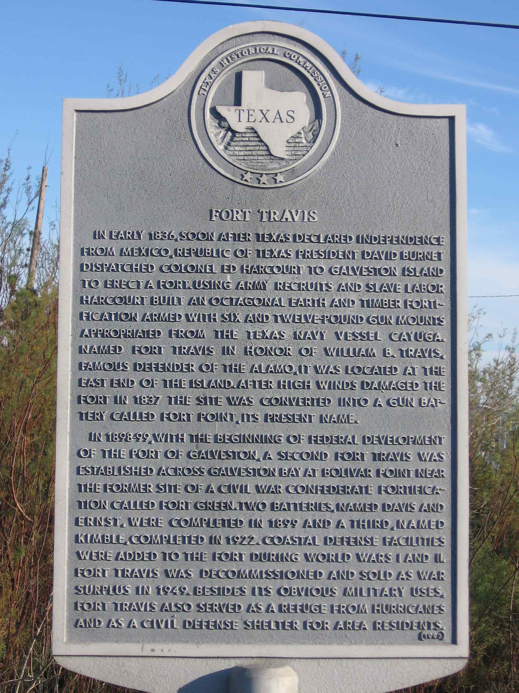
Fort Travis is on the southern shore of the Bolivar Peninsula, adjacent to Port Bolivar. Originally the site of the Confederate Fort Green, with a different Fort Travis located on Galveston Island, [7] this Fort Travis started construction in 1898 and adopted the name from the Galveston Island fort. The new fort had its own railroad spur. [8]
The 1915 Galveston hurricane damaged Port Bolivar, and its port was mostly not rebuilt. [9]
Until the Second World War, the Gulf, Colorado and Santa Fe Railway served the length of the peninsula, extending as far west as Port Bolivar, and provided a ferry service to Galveston for railcars. In 1942, the rail service was cut back to High Island, 28 miles (45 km) east, where the Bolivar Peninsula expands onto the full mainland. The rails on the Bolivar Peninsula were scrapped for the war effort.
After Hurricane Ike, the United States Postal Service temporarily relocated Port Bolivar post office box services to Winnie, 18 miles (29 km) north of High Island. [10]
In 1968, filming began in Port Bolivar on the made-for-television movie, My Sweet Charlie. Starring Patty Duke and Al Freeman Jr., the film focused on the grudging friendship that develops between two fugitives; an outcast, pregnant young white woman, and a black lawyer accused of murder. The actors themselves were targeted for harassment by some local residents, and filming was plagued with problems until then-governor, John Connally, intervened and worked with local authorities to stop harassment of the production company and the actors.
Transportation

Ferry service is provided by the Texas Department of Transportation between Port Bolivar and Galveston. The Galveston-Port Bolivar ferry [11] can accommodate vehicles as heavy as 80,000 pounds, and as long as 65 feet, as high as 13.5 feet and as wide as 8.5 feet. [12] The ferry was closed because of Hurricane Ike [1] but re-opened on November 11, 2008. [13]
Education
Port Bolivar residents are zoned to Galveston Independent School District schools. [14] [15]
Residents attend Crenshaw Elementary and Middle School for grades Pre-K3 through 8 on the peninsula. Residents attend Ball High School in Galveston. [16] As of 2020 [update] there are no particular attendance boundaries in GISD so parents may apply to any school they wish, but only Bolivar Peninsula residents may have school bus service to Crenshaw K-8. [17]
The Crenshaw school was located in Port Bolivar until it was damaged by Hurricane Ike. [14] A resident of Crystal Beach, 10 miles (16 km) east of Port Bolivar, donated land there for a new Crenshaw campus, [18] which opened in 2005. [19]
Galveston ISD (and therefore Port Bolivar) is assigned to Galveston College in Galveston. [20]
Parks and recreation
The Galveston County Department of Parks & Cultural Services, that includes Senior Services, operates the Bolivar Community Center, 1802 Madison Avenue, the Fort Travis Seashore Park at 900 State Highway 87, and the Pilsner Boat Ramp. [21]
Postal service
The United States Postal Service operates the Post Office at 2500 Broadway Avenue, Port Bolivar, TX 77650 - 0736. [22] There is no home delivery on the Bolivar peninsula, only rural delivery.
Religion
The Roman Catholic Archdiocese of Galveston-Houston maintains the nearby Our Lady By The Sea Chapel and Catholic Center in Crystal Beach. [23] Its service area is the entire peninsula. This site is a part of the Holy Family Parish, which has other sites on Galveston Island. [24]
Our Mother of Mercy Church established circa 1950, was previously in Port Bolivar. John Nova Lomax of the Houston Press wrote that the church "was the site of many marriages and funerals for generations of Bolivarians." [23] It closed after Hurricane Ike in 2008. [24] At the end of its life, its congregation numbered 75, although in summer months vacationers also attended church there. Lomax described it as "a dowdy, declining parish". [25] Archbishop Joseph Fiorenza had it razed, despite the lack of damage from the hurricane. [23] The archdiocese argued that keeping the structure would cause further expenses, and that future weather issues could damage the building. [24] Lomax wrote "the archdiocese viewed the church as old and in the way". [25]
Between Hurricane Ike and the opening of Our Lady by the Sea, Bolivar residents attended church in Galveston or in Winnie. John Nova Lomax of the Houston Press wrote that the Our Lady church, dedicated in 2010 and on the site of the former St Therese of Lisieux, "effectively consolidates [St Therese of Lisieux in Crystal Beach] and [Our Mother of Mercy]". [23] Residents opposed to the demolition of Our Mother of Mercy expressed a negative reception to the opening of Our Lady by the Sea. [23]
References
- ^ a b Zucchino, David (September 16, 2008). "A bird's-eye view of Hurricane Ike's handiwork along Texas coast". LA Times. Los Angeles, CA. Retrieved December 27, 2015.
- ^ Rice, Harvey (February 16, 2013). "Ike changed Bolivar Peninsula forever".
- ^ "77650 Zip Code Detailed Profile". City-Data. Onboard Informatics. 2015. Retrieved December 27, 2015.
- ^ "Port Bolivar (zip 77650), Texas". Sperling's Best Places. Sperling's BestPlaces. 2015. Retrieved December 27, 2015.
- ^ "Port Bolivar, TX 77650 ZIP Code Profile". TX HomeTownLocator. HTL Inc. 2015. Retrieved December 27, 2015.
- ^ a b c d A. Pat Daniels. "PORT BOLIVAR, TX". Handbook of Texas Online. Texas State Historical Association. Retrieved June 11, 2013.
- ^ Linton, Tom (October 26, 2009). "Fort Travis Seashore Park has many layers". The Daily News. Retrieved January 10, 2020.
- ^ "Fort Travis". Texas Historical Commission. Retrieved June 11, 2013.
- ^ "Port Bolivar". Galveston County Historical Museum. Archived from the original on November 2, 2012. Retrieved June 11, 2013.
- ^ " Postal Service Relocates Services, Deploys Portable Buildings Archived 2009-05-08 at the Wayback Machine." United States Postal Service. September 18, 2008. Retrieved on April 7, 2009.
- ^ "Galveston-Bolivar Ferry Information". Houston TranStar. Houston TranStar. 2015. Retrieved December 27, 2015.
- ^ "Ferry Information". Ferry Information. Texas Department of Transportation. 2015. Retrieved December 27, 2015.
- ^ Paschenko, Chris. " Rebuilding peninsula a long, arduous process." Galveston County Daily News. November 27, 2008.
- ^ a b " schools." Galveston Independent School District. April 22, 2001. Retrieved on January 5, 2015. "Bolivar School Madison Avenue Pt. Bolivar, TX "
- ^ " SCHOOL DISTRICT REFERENCE MAP (2010 CENSUS): Galveston County, TX." U.S. Census Bureau. Retrieved on January 4, 2015.
- ^ " attendance zones" ( Archive). Galveston Independent School District. January 5, 2015. "GISD students residing on the Bolivar Peninsula attend Bolivar School for grades K-8 and Ball High School for grades 9-12."
- ^ "Schools of Choice". Galveston Independent School District. Retrieved April 22, 2021.
- ^ Thompson, Carter. " Board sets aside money for work on new school" ( Archive). The Galveston County Daily News. February 27, 2003. Retrieved on January 5, 2015. "District staff also has settled on a site — a piece of land in Crystal Beach that the owner has offered to donate to the district."
- ^ " &NodeID=80 Crenshaw School Profile[ permanent dead link]." Galveston Independent School District. Retrieved on November 30, 2008.
- ^ Texas Education Code, Section 130.179, " Galveston College District Service Area Archived 2009-02-11 at the Wayback Machine".
- ^ Galveston County Department of Parks & Cultural Services. Retrieved on July 12, 2019.
- ^ "Post office locations in Galveston County, TX". Post Office Finder. PostOfficeFinder.org. 2015. Retrieved December 27, 2015.
- ^ a b c d e Lomax, John Nova (September 22, 2010). "This Week's Cover Story: Ire Greets Dedication Of Bolivar's New Catholic Chapel". Houston Press. Retrieved June 8, 2020.
- ^ a b c "Catholic facilities in Galveston consolidate". KTRK-TV. November 9, 2009. Retrieved June 8, 2020.
- ^ a b Lomax, John Nova (September 22, 2010). "Our Mother of Mercy". Houston Press. Retrieved June 8, 2020.
Places adjacent to Port Bolivar, Texas | ||||||||||||||||
|---|---|---|---|---|---|---|---|---|---|---|---|---|---|---|---|---|
| ||||||||||||||||
Municipalities and communities of
Galveston County, Texas, United States | ||
|---|---|---|
| Cities |  | |
| Village | ||
| CDPs | ||
|
Other communities | ||
| Footnotes | ‡This populated place also has portions in an adjacent county or counties | |