Piraju | |
|---|---|
 | |
 Location in São Paulo state | |
| Coordinates: 23°11′37″S 49°23′2″W / 23.19361°S 49.38389°W | |
| Country | Brazil |
| Region | Southeast |
| State | São Paulo |
| Area | |
| • Total | 504.5 km2 (194.8 sq mi) |
| Population (2021
[1]) | |
| • Total | 29,970 |
| • Density | 59/km2 (150/sq mi) |
| Time zone | UTC−3 ( BRT) |
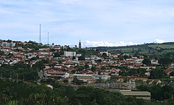
Piraju is a municipality in the state of São Paulo in Brazil. The population is 29,970 (2021 est.) in an area of 504.5 km². [2] The elevation is 646 m. This place name comes from the Tupi language, meaning "yellow fish".
References
External links
- (in Portuguese) https://www.facebook.com/empiraju


