Palmital | |
|---|---|
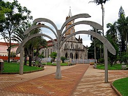
 Praça Matriz | |
 Location in São Paulo state | |
| Coordinates: 22°47′20″S 50°13′3″W / 22.78889°S 50.21750°W | |
| Country | Brazil |
| Region | Southeast |
| State | São Paulo |
| Area | |
| • Total | 548 km2 (212 sq mi) |
| Population (2020
[1]) | |
| • Total | 22,272 |
| • Density | 41/km2 (110/sq mi) |
| Time zone | UTC−3 ( BRT) |
Palmital is a municipality in the state of São Paulo, Brazil. The population is 22,272 (2020 est.) in an area of 548 km2. [2] Its altitude is 508m. Its economy is based on agriculture and cattle raising. The town is known for having the biggest carnaval festivities of the area.
See also
References

