


The following outline is provided as an overview of and topical guide to Jamaica:
Jamaica – sovereign island nation located on the Island of Jamaica of the Greater Antilles archipelago in the Caribbean Sea. [1] It is 234 kilometres (145 mi) long and 80 kilometres (50 mi) at its widest. It lies about 145 kilometres (90 mi) south of Cuba and 190 kilometres (120 mi) west of the Hispaniola. Its indigenous Arawakan-speaking Taíno inhabitants named the island Xaymaca, meaning the "Land of Wood and Water", or the "Land of Springs". [2] Formerly a Spanish possession known as Santiago, it later became the British West Indies Crown colony of Jamaica. It is the third most populous anglophone country in the Americas, after the United States and Canada.
General reference

- Pronunciation:
- Common English country name: Jamaica
- Official English country name: Jamaica
- Common endonym(s):
- Official endonym(s):
- Adjectival(s): Jamaican
- Demonym(s):
- Etymology: Name of Jamaica
- International rankings of Jamaica
- ISO country codes: JM, JAM, 388
- ISO region codes: See ISO 3166-2:JM
- Internet country code top-level domain: .jm
Geography of Jamaica

- Jamaica is...
- Location:
-
Northern Hemisphere and
Western Hemisphere
- North America (though not on the mainland)
- Atlantic Ocean
- Time zone: UTC-05
- Extreme points of Jamaica
- High: Blue Mountain Peak 2,256 m (7,402 ft)
- Low: Caribbean Sea 0 m
- Land boundaries: none
- Coastline: Caribbean Sea 1,022 km
-
Northern Hemisphere and
Western Hemisphere
- Population of Jamaica: 2,714,000 - UN Estimate 137th most populous country
- Area of Jamaica: 10,991 km2 - 166th largest country
- Atlas of Jamaica
Environment of Jamaica

- Climate of Jamaica
- Renewable energy in Jamaica
- Geology of Jamaica
- Protected areas of Jamaica
- Wildlife of Jamaica
- Effects of Hurricane Charley in Jamaica
Natural geographic features of Jamaica
- Beaches of Jamaica
- Islands of Jamaica
- Lakes of Jamaica
- Mountains of Jamaica
- Rivers of Jamaica
- Valleys of Jamaica
- World Heritage Sites in Jamaica (none)
Regions of Jamaica
Ecoregions of Jamaica
Administrative divisions of Jamaica

Administrative divisions of Jamaica Administratively, Jamaica is divided into fourteen parishes. They are grouped into three historic counties, which have no administrative relevance (traditional capitals in parentheses):
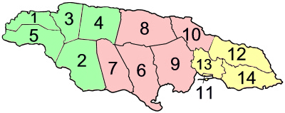
- Surrey ( Kingston) – yellow
- Middlesex ( Spanish Town) – pink
- Cornwall ( Montego Bay) – green
| Parish | Area km2 |
Population Census 2001 |
Capital | |
| Cornwall County | ||||
| 1 | Hanover | 450.4 | 67,037 | Lucea |
| 2 | Saint Elizabeth | 1,212.4 | 146,404 | Black River |
| 3 | Saint James | 594.9 | 175,127 | Montego Bay |
| 4 | Trelawny | 874.6 | 73,066 | Falmouth |
| 5 | Westmoreland | 807.0 | 138,947 | Savanna-la-Mar |
| Middlesex County | ||||
| 6 | Clarendon | 1,196.3 | 237,024 | May Pen |
| 7 | Manchester | 830.1 | 185,801 | Mandeville |
| 8 | Saint Ann | 1,212.6 | 166,762 | Saint Ann's Bay |
| 9 | Saint Catherine | 1,192.4 | 482,308 | Spanish Town |
| 10 | Saint Mary | 610.5 | 111,466 | Port Maria |
| Surrey County | ||||
| 11 | Kingston (parish)(1) (2) | 21.8 | 96,052 | Kingston |
| 12 | Portland | 814.0 | 80,205 | Port Antonio |
| 13 | Saint Andrew(1) | 430.7 | 555,828 | Half Way Tree |
| 14 | Saint Thomas | 742.8 | 91,604 | Morant Bay |
| Jamaica | 10,990.5 | 2,607,631 | Kingston | |
(1) The parishes of Kingston and Saint Andrew together form the
Kingston and St. Andrew Corporation.
(2) The parish of Kingston does not encompass all of the city of Kingston. Most of the city is in the parish of St. Andrew.
Municipalities of Jamaica
Demography of Jamaica
Government and politics of Jamaica
- Form of government: parliamentary multi-party representative democratic constitutional monarchy
- Capital of Jamaica: Kingston
- Elections in Jamaica
- Political parties in Jamaica
Branches of the government of Jamaica
Executive branch of the government of Jamaica
-
Head of state:
Charles III,
King of Jamaica
- Governor General of Jamaica, the Monarch's representative
- Head of government: Andrew Holness, Prime Minister of Jamaica
- Cabinet of Jamaica
Legislative branch of the government of Jamaica
Judicial branch of the government of Jamaica
- Supreme Court of Jamaica
- Court of Appeals of Jamaica
- Resident Magistrate's Courts of Jamaica
- Gun Court
- Commercial Court of Jamaica
- Petty Courts of Jamaica
Foreign relations of Jamaica
International organization membership
Jamaica is a member of: [1]
Law and order in Jamaica
- Cannabis in Jamaica
- Capital punishment in Jamaica
- Constitution of Jamaica
- Crime in Jamaica
- Human rights in Jamaica
- Law enforcement in Jamaica
- List of prisons in Jamaica
Military of Jamaica
- Command
- Forces
- Military history of Jamaica
- Military ranks of Jamaica
Local government in Jamaica
History of Jamaica
Culture of Jamaica
- Architecture of Jamaica
- Cuisine of Jamaica
- Festivals in Jamaica
- Languages of Jamaica
- Media in Jamaica
- National symbols of Jamaica
- People of Jamaica
- Prostitution in Jamaica
- Public holidays in Jamaica
- Records of Jamaica
- Religion in Jamaica
- List of museums in Jamaica
- List of National Heritage Sites in Jamaica
- World Heritage Sites in Jamaica(none)
Art in Jamaica
- Art in Jamaica
- Cinema of Jamaica
- Literature of Jamaica
- Music of Jamaica
- Television in Jamaica
- Theatre in Jamaica
Sports in Jamaica
Economy and infrastructure of Jamaica
- Economic rank, by nominal GDP (2007): 110th (one hundred and tenth)
- Agriculture in Jamaica
- Banking in Jamaica
- Communications in Jamaica
- Companies of Jamaica
-
Currency of Jamaica:
Dollar
- ISO 4217: JMD
- Energy in Jamaica
- Mining in Jamaica
- Tourism in Jamaica
- Transport in Jamaica
- Jamaica Stock Exchange
Education in Jamaica
- List of schools in Jamaica
- List of colleges in Jamaica
- List of universities in Jamaica
Infrastructure of Jamaica
- Health care in Jamaica
- Transportation in Jamaica
- Water supply and sanitation in Jamaica
- Water resources management in Jamaica
See also
- Index of Jamaica-related articles
- List of Jamaica-related topics
- List of international rankings
- Member state of the Commonwealth of Nations
- Member state of the United Nations
- Monarchy of Jamaica
- Outline of geography
- Outline of North America
References
- ^ a b "Jamaica". The World Factbook. United States Central Intelligence Agency. July 6, 2009. Retrieved July 23, 2009.
- ^ The United Confederation of Taíno People. "Taíno Dictionary" (in Spanish). Archived from the original on 2007-10-16. Retrieved 2007-10-18.
External links
- Official website of Queen Elizabeth as Queen of Jamaica
- Official website of the Jamaica Information Service
- The Cabinet Office of the Government of Jamaica
- National Library of Jamaica materials in the Digital Library of the Caribbean
 Wikimedia Atlas of Jamaica
-
 Jamaica travel guide from Wikivoyage
 - Outline of Jamaica at Curlie
- Jamaica. The World Factbook. Central Intelligence Agency.
- Jamaica Environment Trust