This article lacks
inline citations besides
NRIS, a database which provides minimal and sometimes ambiguous information. (May 2014) |
Normandy Isles Historic District | |
 | |
| Location | Miami Beach, Florida, U.S. |
|---|---|
| Coordinates | 25°51′16.4″N 80°7′51.7″W / 25.854556°N 80.131028°W |
| NRHP reference No. | 08001041 [1] |
| Added to NRHP | November 12, 2008 [1] |
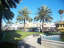
Normandy Isles Historic District is a U.S. Historic District encompassing the Normandy Isles neighborhood of Miami Beach, Florida. It is roughly bounded by the Normandy Shores Golf Course, Indian Creek, Biscayne Bay, Rue Versailles, 71st Street, and Rue Notre Dame. On November 12, 2008, it was added to the U.S. National Register of Historic Places. [1]
References
- ^ a b c "Weekly List Of Actions Taken On Properties: 11/3/08 through 11/7/08". National Register of Historic Places. National Park Service. December 30, 2008.
External links
Wikimedia Commons has media related to
Normandy Isles Historic District.


