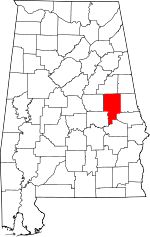
This is a list of the National Register of Historic Places listings in Tallapoosa County, Alabama.
This is intended to be a complete list of the properties and districts on the National Register of Historic Places in Tallapoosa County, Alabama, United States. Latitude and longitude coordinates are provided for many National Register properties and districts; these locations may be seen together in a Google map. [1]
There are 9 properties and districts listed on the National Register in the county.
This
National Park Service list is complete through
NPS recent listings posted April 12, 2024.
[2]
| [3] | Name on the Register | Image | Date listed [4] | Location | City or town | Description |
|---|---|---|---|---|---|---|
| 1 | Alexander City Commercial Historic District |  |
June 22, 2000 ( #00000711) |
Portions of Broad, Main, Green, Alabama, and Jefferson Sts., and Courthouse Sq. 32°56′44″N 85°57′14″W / 32.945556°N 85.953889°W | Alexander City | |
| 2 | Avondale Historic District |  |
August 9, 2005 ( #05000837) |
Between Rose Ave. and Scott St., and Hillabee St. and 7th St. 32°56′24″N 85°56′28″W / 32.94°N 85.941111°W | Alexander City | Avondale Mills closed in 2006 and is now known as Parkdale Mills. |
| 3 | A.J. and Emma E. Thomas Coley House |  |
January 3, 1991 ( #90002109) |
455 Hillabee St. 32°56′51″N 85°56′55″W / 32.94758°N 85.94874°W | Alexander City | |
| 4 | Dadeville Historic District |  |
July 10, 2013 ( #13000471) |
Lafayette, East, South, S. Tallassee & West Sts. 32°49′53″N 85°45′49″W / 32.83143°N 85.76367°W | Dadeville | |
| 5 | Reuben Herzfeld House |  |
August 22, 1995 ( #95001023) |
497 Hillabee St. 32°56′51″N 85°56′53″W / 32.94762°N 85.94806°W | Alexander City | Built in 1890, the house is also known as the Mistletoe Bough Bed & Breakfast. |
| 6 | Horseshoe Bend National Military Park |  |
October 15, 1966 ( #66000060) |
Tallapoosa River, 12 miles north of Dadeville on
State Route 49 32°58′15″N 85°44′18″W / 32.97083°N 85.73833°W | Dadeville | |
| 7 | North Central Historic District |  |
August 11, 2005 ( #05000833) |
Between Hall and Summer, Warren and Hillabee, Warren and Ridgeway, and MLK and Hillabee 32°57′31″N 85°57′32″W / 32.958611°N 85.958889°W | Alexander City | 800 acres (3.2 km2) historic district including 349 contributing buildings |
| 8 | Russell Family Historic District |  |
March 21, 2006 ( #05000839) |
35, 65, and 85 N. Central, 228 and 334 Robin Hill, and 101 Russwood 32°56′36″N 85°57′43″W / 32.943333°N 85.961944°W | Alexander City | |
| 9 | South Central Historic District |  |
August 9, 2005 ( #05000840) |
Bounded by Broad St., Tallpoosa St., Cherokee Rd., Bishop St., Franklin St., and Willow St. 32°56′07″N 85°57′03″W / 32.935278°N 85.950833°W | Alexander City | About 200 acres (0.81 km2) area with 137 contributing resources, just south of Alexander City's downtown core. |
See also
Wikimedia Commons has media related to
National Register of Historic Places in Tallapoosa County, Alabama.
- List of National Historic Landmarks in Alabama
- National Register of Historic Places listings in Alabama
References
- ^ The latitude and longitude information provided in this table was derived originally from the National Register Information System, which has been found to be fairly accurate for about 99% of listings. Some locations in this table may have been corrected to current GPS standards.
- ^ National Park Service, United States Department of the Interior, "National Register of Historic Places: Weekly List Actions", retrieved April 12, 2024.
- ^ Numbers represent an alphabetical ordering by significant words. Various colorings, defined here, differentiate National Historic Landmarks and historic districts from other NRHP buildings, structures, sites or objects.
- ^ The eight-digit number below each date is the number assigned to each location in the National Register Information System database, which can be viewed by clicking the number.


