| Mount Allison | |
|---|---|
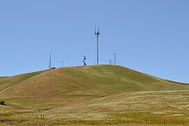
 from the east | |
| Highest point | |
| Elevation | 2,664 ft (812 m) NAVD 88 [1] |
| Coordinates | 37°29′56″N 121°52′17″W / 37.498913944°N 121.871297656°W [1] |
| Geography | |
| Parent range | Diablo Range |
| Topo map | USGS Calaveras Reservoir |
Mount Allison is a peak of the Diablo Range, located in the East Bay southeast of Fremont, California.
Geography
Mount Allison is part of a ridge that also includes Mission Peak and Monument Peak. Unlike those other two peaks, Mount Allison is located on unincorporated private property owned by a broadcasting company. [2]
Broadcasting antennas
Owned by Communication and Control, Inc. (CCI), a large free-standing broadcasting antenna on Mount Allison broadcasts two Spanish channels, channel 14 ( Univision KDTV) and channel 48 ( Telemundo KSTS). Erected on February 25, 1998, the antenna is 443 feet (135 m) high and has three prongs at the top. Several smaller towers and dishes are also present. [3]
KTSF has relocated its transmitters to Mount Allison on May 7, 2018, previously located atop San Bruno Mountain. KTLN-TV and KAXT-CD relocated their transmitters to Mount Allison on June 1, 2018, previously located atop Mount Burdell.
References
- ^ a b "2659=Allison". NGS Data Sheet. National Geodetic Survey, National Oceanic and Atmospheric Administration, United States Department of Commerce. Retrieved 2009-08-05.
- ^ "Mount Allison". SummitPost.org. Retrieved 2011-05-07.
- ^ "Antenna Structure Registration 607495". Federal Communications Commission. Retrieved 2009-08-05.
External links
-
 Media related to
Mount Allison at Wikimedia Commons
 - "Communication and Control, Inc. (CCI)". Retrieved 2011-05-08.
- "Mount Allison". Geographic Names Information System. United States Geological Survey, United States Department of the Interior. Retrieved 2009-08-05.
- "Mount Allison, California". Peakbagger.com. Retrieved 2009-08-05.
