Mosbach | |
|---|---|
 | |
 Coat of arms | |
Location of Mosbach within Neckar-Odenwald-Kreis district  | |
 Mosbach  Mosbach | |
| Coordinates: 49°21′8″N 9°8′48″E / 49.35222°N 9.14667°E | |
| Country | Germany |
| State | Baden-Württemberg |
| Admin. region | Karlsruhe |
| District | Neckar-Odenwald-Kreis |
| Subdivisions | 6 |
| Government | |
| • Lord mayor (2022–30) | Julian Stipp [1] |
| Area | |
| • Total | 62.23 km2 (24.03 sq mi) |
| Elevation | 156 m (512 ft) |
| Population (2021-12-31)
[2] | |
| • Total | 23,307 |
| • Density | 370/km2 (970/sq mi) |
| Time zone | UTC+01:00 ( CET) |
| • Summer ( DST) | UTC+02:00 ( CEST) |
| Postal codes | 74821 |
| Dialling codes | 06261, 06263 (Reichenbuch), 06267 (Sattelbach) |
| Vehicle registration | MOS, BCH |
| Website | www.mosbach.de |
Mosbach (German: [ˈmoːsˌbax] ⓘ; South Franconian: Mossbach) is a town in the north of Baden-Württemberg, Germany. It is the seat of the Neckar-Odenwald district and has a population of approximately 25,000 distributed in six boroughs: Mosbach Town, Lohrbach, Neckarelz, Diedesheim, Sattelbach and Reichenbuch.
Geography
Located about 35 km east of Heidelberg, it is situated south of the Odenwald mountains at a height of 134-354m at the confluence of the Neckar and the Elz. The town is part of the conservation area Neckartal-Odenwald Nature Park and the UNESCO Bergstrasse-Odenwald Nature Park.
| Climate data for Mosbach (precipitation normals 1991-2020) | |||||||||||||
|---|---|---|---|---|---|---|---|---|---|---|---|---|---|
| Month | Jan | Feb | Mar | Apr | May | Jun | Jul | Aug | Sep | Oct | Nov | Dec | Year |
| Average precipitation mm | 90.0 | 76.6 | 77.2 | 51.1 | 81.0 | 71.1 | 81.6 | 71.1 | 67.1 | 79.8 | 82.6 | 109.6 | 938.8 |
| Average precipitation inches | 3.54 | 3.02 | 3.04 | 2.01 | 3.19 | 2.80 | 3.21 | 2.80 | 2.64 | 3.14 | 3.25 | 4.31 | 36.95 |
| Source: Deutscher Wetterdienst [3] | |||||||||||||
History
The settlement of Mosbach developed around the Benedictine monastery of Mosbach Abbey ("Monasterium Mosabach"), the first written record of which dates from the 9th century. In 1241 rights and privileges had been granted to Mosbach as an Imperial free city. These rights were lost in 1362 when Mosbach became part of the Electorate of the Palatinate. With the division of the lands of King Rupert in 1410, Mosbach became the capital of a small principality known as Palatinate-Mosbach as the inheritance for his son Otto I. With the death of his brother John, Count Palatine of Neumarkt 1443, the territory of Palatinate-Neumarkt was added in a personal union to Palatinate-Mosbach creating the territory of Palatinate-Mosbach-Neumarkt. This principality was dissolved with the death of Count Palatine Otto II in 1499. The city and adjoining territory reverted to the Electorate of the Palatinate, and Mosbach became the capital of the administrative district of "Oberamt Mosbach". In 1806 the city was made part of the Grand Duchy of Baden. In World War II, the Mosbach area was the location of a Daimler-Benz [4] underground airplane engine factory, [4] [5] codenamed "Goldfisch". [4] It was occupied by the 289th Combat Engineer Battalion in the immediate postwar period.
Twin towns and sister cities
-
 Budapest II, Hungary
 -
 Château-Thierry, France
 -
 Finike, Turkey
 -
 Lymington, England, United Kingdom
 -
 Rosolina, Italy
Points of interest
Historic sites include:
- the historic town centre with the pedestrian area and
timber-framed houses, such as:
- the Palm House built in 1610, which is the town's emblem
- the Salzhaus, which is the oldest timber-framed house
- old town hall with tower
- the former collegiate church, now a parish church, of which the nave is used by the Protestants, and the chancel by the Roman Catholics
- the Tempelhaus in Neckarelz, which has the character of both a castle and a church.
Mosbach lies on two heritage routes:
- the Burgenstraße (“Castle Road”), linking many historic castles
- the Deutsche Fachwerkstraße (“German Half-timbered Road”), joining the locations of many of the best German half-timbered buildings
-
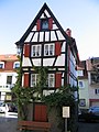 Kickelhain House
 -
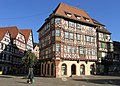 The “Palmsche Haus” at the market place
 -
 Market place, opposite side to the “Palmsche Haus”
 -
 Town hall
 -
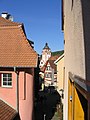 A picturesque corner
 -
 Mosbach and the other cities on the Neckar River


See also
References
- ^ Oberbürgermeisterwahl Mosbach 2022, Staatsanzeiger.
- ^ "Bevölkerung nach Nationalität und Geschlecht am 31. Dezember 2021" [Population by nationality and sex as of December 31, 2021] (CSV) (in German). Statistisches Landesamt Baden-Württemberg. June 2022.
- ^ "Niederschlag: vieljährige Mittelwerte 1991 - 2020" [Precipitation: Long-term averages for 1991-2020]. dwd.de (in German). Deutscher Wetterdienst. Retrieved 23 February 2024.
- ^ a b c "A Year of Potsdam". Office of Military Government. Economics Division. 1946.
-
^
Gurney, Gene (Major, USAF) (1962), The War in the Air: a pictorial history of World War II Air Forces in combat, New York: Bonanza Books, p. 220
{{
citation}}
: CS1 maint: multiple names: authors list ( link) - ^ "Partnerstädte". mosbach.de (in German). Mosbach. Retrieved 2021-02-25.
Towns and municipalities in
Neckar-Odenwald (district) | ||
|---|---|---|
 | ||
| International | |
|---|---|
| National | |
| Geographic | |