Santo Ângelo | |
|---|---|
Micro-region | |
 | |
| Country | Brazil |
| State | Rio Grande do Sul |
| Mesoregion | Noroeste Rio-Grandense |
| Municipalities | 16 |
| Area | |
| • Total | 10,751 km2 (4,151 sq mi) |
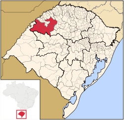
The Santo Ângelo micro-region (Microrregião de Santo Ângelo) is a micro-region in the western part of the state of Rio Grande do Sul, Brazil. The area is 10,750.721 km2.
Municipalities
The microregion consists of the following municipalities: [1]
- Bossoroca
- Catuípe
- Dezesseis de Novembro
- Entre-Ijuís
- Eugênio de Castro
- Giruá
- Pirapó
- Rolador
- Santo Ângelo
- Santo Antônio das Missões
- São Luiz Gonzaga
- São Miguel das Missões
- São Nicolau
- Senador Salgado Filho
- Ubiretama
- Vitória das Missões
References
- ^ Instituto Brasileiro de Geografia e Estatística[ permanent dead link], territorial division.
28°17′56″S 54°15′46″W / 28.29889°S 54.26278°W
