- See Bananal for namesakes
Microregion of Bananal | |
|---|---|
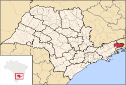
 Location of Microregion of Bananal in the state of São Paulo | |
| Country | |
| Region | Southeast |
| State | |
| Mesoregion | Vale do Paraíba Paulista |
| Time zone | UTC-3 ( UTC-3) |
| • Summer ( DST) | UTC-2 ( UTC-2) |
The Microregion of Bananal ( Portuguese: Microrregião de Bananal) is a microregion in the east of São Paulo State, Brazil.
It is the easternmost microregion of the state, bordered by the state of Rio de Janeiro to the east.
Municipalities
The microregion consists of the following municipalities: [1]
References
- ^ Instituto Brasileiro de Geografia e Estatística[ permanent dead link], territorial division.
See also
- Bananal Island
- the former Catholic Territorial Prelature of Bananal
22°41′02″S 44°19′22″W / 22.68389°S 44.32278°W