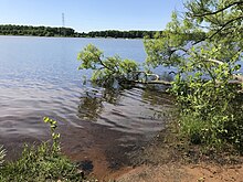
The Richard J. Coffee Mercer County Park is a recreational park located in West Windsor Township and small western sections of Hamilton and Lawrence Townships in Mercer County, New Jersey. Originally and still more commonly known as Mercer County Park, the park was renamed in October 2009 in honor of New Jersey State Senator Richard J. Coffee. [1]
The park encompasses over 2,500 acres (10 km2) covering much of southern West Windsor, with portions extending into adjacent Hamilton and Lawrence. Mercer Lake, located within the park, is the home for the US Olympic Rowing Team's training center. [2] The National Softball Association honored the Mercer County Park Commission with its "Outstanding Parks Award" for the softball fields and facilities in Mercer County Park. It has served as the home field for the New Jersey Pride of the Major League Lacrosse for one game in 2004, 2005 and 2006. It has also hosted semi-professional Minor League Cricket matches.
History

The land was acquired between the late 1960s and the early 1970s. It consists of 50-plus pieces of property, which included many farms. Ground was broken for the park in June 1971. Because of the construction of Routes I-95 and I-295, the lake basin was excavated and paid for by selling gravel to the highway contractors, which in turn helped excavate the basin now known as Lake Mercer.
Facilities

- 36 holes of golf (Mercer Oaks East and West)
- Seventeen athletic fields used for soccer, football, and lacrosse
- Ice skating center [3] (home to the Mercer Bulldogs special hockey team [1])
- Tennis center (24 total courts - six of which are covered and are lit)
- Cross country course
- Mountain biking area
- Boat house/marina
- Finn Caspersen Rowing Center
- Crew course
- Nature trail
- Fishing
- Hiking and jogging area
- 3-mile paved trail
- Picnic areas
- Dog parks
- Frisbee golf course
- Three sand volleyball courts
- Two cricket pitches
- Seven basketball courts
- Ten softball fields
- Veterans Memorial Park
- Parking facilities
- Seven washrooms
- 9/11 Memorial, a steel beam weighing one ton and ten feet long was given to the county by the Port Authority of New York and New Jersey in March 2011 and is now displayed at Mercer County Park to commemorate Mercer County victims who died in the September 11 terrorist attacks in Lower Manhattan.
References
- ^ Fair, Matt. "Mercer County Park renamed after politician Richard Coffee", The Times (Trenton), October 17, 2009. Accessed February 22, 2011.
- ^ "Know, know, know your boat". The Christian Science Monitor. 2008-07-17. Retrieved 2008-12-03.
- ^ "Mercer County Ice Skating Center". RinkAtlas. Retrieved 29 January 2018.
External links
- Mercer Bulldogs Official Website
- "Mercer County Park", Mercer County, New Jersey