You can help expand this article with text translated from
the corresponding article in French. (December 2017) Click [show] for important translation instructions.
|
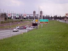
 Montreal entrance to tunnel, 2009 | |
| Overview | |
|---|---|
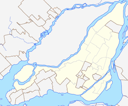
| Location | Montreal, Quebec, Canada |
| Route | |
| Crosses | St. Lawrence River |
| Operation | |
| Opened | March 11, 1967 |
| Traffic | 120,000 [1] |
| Character | Limited access highway |
| Technical | |
| Length | 1,391 m (4,563.6 ft) (tunnel section) 409 m (1,341.9 ft) (causeway section) |
| No. of lanes | 6 |
| Tunnel clearance | 4.4 m (14 ft 5+1⁄4 in) |
| Width | 37 m (121.4 ft) |
The Louis-Hippolyte Lafontaine Bridge–Tunnel ( French: Pont-Tunnel Louis-Hippolyte-La Fontaine) is a highway bridge–tunnel running over and beneath the Saint Lawrence River. It connects the Montreal borough of Mercier–Hochelaga-Maisonneuve with the south shore of the river at Longueuil, Quebec.
Named after Lower Canada political reformer Louis-Hippolyte Lafontaine, the Lafontaine Tunnel is an immersed tube structure, measuring 1,391 m (4,563.6 ft) long. It carries the Autoroute 25 expressway and passes beneath the main shipping channel in the Saint Lawrence River immediately downstream from the Saint Lawrence Seaway. It surfaces on Île Charron ( Îles de Boucherville at entrance/exit #1 of Autoroute 25), then continues by bridge to Longueuil. The bridge-tunnel sees about 120,000 daily crossings, of which 13% are trucks. [1] Its construction began in 1963 and it opened on March 11, 1967. [2] [3]
History
In 1960, the construction of the Trans-Canada Highway (TCH) through Quebec from the Ontario border to Rivière-du-Loup was announced. In Montreal, to avoid having to build a huge bridge that would have disfigured the city and destroyed a neighbourhood, engineers opted for the construction of a tunnel located under the Saint Lawrence River and dug a trench under the river bed and buried the tunnel sections 4.6 metres (15 ft) to 6.1 metres (20 ft) under the river bed.
The Longue-Pointe church had to be demolished to make way for the tunnel, and 300 families were expropriated from the village in 1964. [4] The construction was completed in March 1967, just before the opening of Expo 67. Construction cost $75 million. [5]
A major four-year refurbishment of the tunnel began in 2020, originally planned to complete in 2024 at a cost of $1.2 billion, but in 2022 it was announced that the project would take a year longer than expected, completing in 2025 at a total cost of $2.1 billion. [6]
Specifications

Each of the seven tunnel sections weighs 32,000 t (31,000 long tons; 35,000 short tons), [3] is 110 metres (360 ft) long, 37 metres (121 ft) wide and rises to a height of 8 metres (26 ft). In total, the bridge–tunnel is 1.8 kilometres (1.1 mi) long.
The tunnel was built with sections prefabricated in dry dock and then sunk in the river, [7] 24 metres (79 ft) below the surface of the water.
It is one of the largest prestressed concrete structures in the world and is the longest bridge-tunnel in Canada. [2]
See also
References
- ^ a b "Rebuilding Louis-Hippolyte-La Fontaine Tunnel a four-year ordeal". Montreal Gazette. June 21, 2018. Retrieved November 3, 2018.
- ^ a b "Louis-Hippolyte-Lafontaine, the longest bridge-tunnel in Canada, turns 50". Montreal Gazette. March 11, 2017. Retrieved December 20, 2017.
- ^ a b "Il y a 50 ans, le pont-tunnel était inauguré". Métro (in Canadian French). March 9, 2017. Retrieved December 20, 2017.
- ^ "Un village sacrifié pour le pont-tunnel". Métro (in Canadian French). March 9, 2017. Retrieved December 20, 2017.
- ^ "At 50, the Louis-Hippolyte-La Fontaine bridge-tunnel still a world-class wonder". CBC News. Retrieved December 20, 2017.
- ^ "Additional year of construction -- and traffic disruptions -- for Lafontaine tunnel revamp". CTV News. August 4, 2022. Retrieved August 7, 2022.
- ^ Ministère des Transports (March 28, 2014). "Construction du Pont-tunnel Louis-Hippolyte-La Fontaine". YouTube (in French). Archived from the original on December 21, 2021. Retrieved December 21, 2017.
External links
- Bridges in Montreal
- Bridge–tunnels in North America
- Transport in Longueuil
- Bridges over the Saint Lawrence River
- Bridges completed in 1967
- Tunnels completed in 1967
- Bridges on the Trans-Canada Highway
- Tunnels on the Trans-Canada Highway
- Buildings and structures in Longueuil
- Mercier–Hochelaga-Maisonneuve
- Road bridges in Quebec
- Road tunnels in Quebec
- Immersed tube tunnels in Canada
- 1967 establishments in Quebec
