| U.S. Routes in California | |
|---|---|
Highway shields for US 6, US 95, and US 101 | |
U.S. Routes highlighted in red | |
| System information | |
| Maintained by Caltrans | |
| Length | 1,721.644 mi (2,770.717 km) |
| Formed | November 11, 1926 [1] |
| Highway names | |
| US Highways | U.S. Route XX (US XX) |
| Special Routes: | U.S. Route XX Alternate (US XX Alt.); U.S. Route XX Business (US XX Bus.); |
| System links | |
.svg)
.svg)
.svg)
This is a list of U.S. Routes in the U.S. state of California. It includes routes defined by the California State Legislature but never built, as well as routes entirely relinquished to local governments. It also includes the routes that were decommissioned during the 1964 state highway renumbering.
Each U.S. Route in California is maintained by the California Department of Transportation (Caltrans) and is assigned a Route (officially State Highway Route [2] [3]) number in the Streets and Highways Code (Sections 300-635). Under the code, the state assigns a unique Route X to each highway and does not differentiate between state, US, or Interstate highways.
California still uses a version of the 1961 U.S. Route shield, featuring a simplified cutout shield containing only the outer border, "U S," and the route marker. All other U.S. states adopted the 1971 version of the marker, consisting of a white shield outline on a black square background.
Mainline routes
- Lengths for each state route were initially measured as they were during the 1964 state highway renumbering (or during the year the route was established, if after 1964) based alignment that existed at the time, and do not necessarily reflect the current mileage. Portions of some routes have been relinquished to or are otherwise maintained by local or other governments, and may not be included in the length listed below. Several routes are broken into non-contiguous pieces, and their lengths may not reflect the overlaps that would be required to make them continuous. Some routes may also have a gap because it is either explicitly defined in the California Streets and Highways Code or due to an unconstructed portion, and the listed length may or may not reflect the gap.
- If a route was renumbered, the old or new number is given in the "notes" column.
- Concurrences are not explicitly codified in the Streets and Highways Code; such highway segments are listed on only one of the corresponding legislative route numbers. When a highway is broken into such segments, the total length recorded by Caltrans only reflects those non-contiguous segments, and does not include those overlaps that would be required to make the route continuous.
- Since the 1990s, a number of piecemeal relinquishments have been made. These are generally reflected in the length but not the termini.
- Former termini are not shown if they are along the current route, meaning that the route was simply extended.
- A U.S. Route may be partially signed as an Interstate Highway, while the remaining segment is signed as a U.S. Route.
| Number | Length (mi) [4] [a] | Length (km) | Southern or western terminus | Northern or eastern terminus | Formed | Removed | Notes | |
|---|---|---|---|---|---|---|---|---|
| 40.505 | 65.186 | US 395 in Bishop | Nevada state line | 1937 | current | Until 1964 western terminus was in Long Beach | ||
| — | — | US 101 in San Francisco | Nevada state line | 1926 | 1964 | Replaced by I-80 | ||
| 87.3 [b] [c] | 140.5 | First Street in San Jose | French Camp Road in French Camp | 1926 | 1931 | Renumbered as US 50 | ||
| 108.624 | 174.813 | I-80 in West Sacramento | Nevada state line | 1926 | current | Until 1964 western terminus was in San Francisco | ||
| 255 [b] [c] | 410 | I-5 and former US 99 in Los Angeles | Arizona state line | 1926 | 1972 | Replaced by I-10; ran concurrently with US 70 | ||
| 315 [b] [c] | 507 | SR 1 and former US 101 Alt. in Santa Monica | Arizona state line | 1926 | 1969 | Replaced by I-40 and other routes | ||
| 255 [b] [c] | 410 | I-5 and former US 99 in Los Angeles | Arizona state line | 1926 | 1964 | Replaced by I-10; ran concurrently with US 60 | ||
| 176.53 [b] [c] | 284.10 | I-5 and former US 101 in San Diego | Arizona state line | 1926 | 1964 | Replaced by I-8 | ||
| — | — | SR 1 and former US 101 Alt. in Long Beach | Nevada state line | 1926 | 1971 | Replaced by I-15 and SR 91 | ||
| 116.721 [d] | 187.844 | Arizona state line | Nevada state line | 1930 | current | |||
| 54.364 | 87.490 | I-5 in Weed | Oregon state line | 1935 | current | |||
| 754 [b] [c] | 1,213 | Fed. 5 near Calexico | Oregon state line | 1926 | 1964 | Replaced by I-5; completely decommissioned in 1972 | ||
| 141 [b] [c] | 227 | SR 99 and former US 99 in Wheeler Ridge | SR 99 and former US 99 in Sacramento | 1929 | 1933 | Most of former US 99E is now part of SR 99 | ||
| — | — | SR 99 and former US 99 in Wheeler Ridge | SR 99 and former US 99 in Sacramento | 1929 | 1964 | Replaced by majority of I-5 | ||
| 808.111 [b] | 1,300.529 | I-5 / I-10 / SR 60 in Los Angeles | Oregon state line | 1926 | current | Segment across the Golden Gate Bridge is not officially recognized as part of the state highway system; until 1964 southern terminus was in San Diego | ||
| — | — | I-880 and US 101 | I-580 and US 101 | 1929 | 1940 | Reverted to US 101 after US 101E was decommissioned | ||
| — | — | US 101 | US 101 | 1929 | 1940 | Renumbered into SR 17 | ||
| 36.41 | 58.60 | US 101 near Crescent City | Oregon state line | 1926 | current | |||
| 304 [b] [c] | 489 | US 101 in Arcata | US 395 in Alturas | 1934 | 1964 | Replaced by the majority of SR 299 | ||
| 556.909 [b] [c] | 896.258 | I-15 near Hesperia | Oregon state line | 1979 | current | Split into two segments, as the highway clips into Nevada to serve Carson City and Reno; until 1969 southern terminus was in San Diego | ||
| 137 [b] [c] | 220 | US 101 in Ventura | SR 99 and former US 99 in Bakersfield | 1934 | 1964 | Replaced by SR 33 and SR 119 | ||
| 526 [b] [c] | 847 | SR 1 in Morro Bay | Nevada state line | 1935 | 1965 | Replaced by SR 58 and I-15; ran concurrently with former US 91 | ||
| ||||||||
-
 Road sign on US 6 showing that it is 3205 miles to its eastern end in Provincetown, Massachusetts
 -
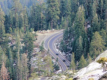 US 50 westbound as it winds down Echo Summit towards the west
 -
 US 95 southbound at the California-Nevada state line
 -
 US 97 sign on I-5 in the City of Weed
 -
 US 101 northbound approaching Gaviota Tunnel through the Santa Ynez Mountains
 -
 US 199 southbound at the California-Oregon state line
 -


Special routes
See also
Notes
- ^ Lengths rounded to the nearest mile or tenth-mile are estimated from various sources including Google Maps.
- ^ a b c d e f g h i j k l m n o p q Portions of this route have been relinquished to or are otherwise maintained by local or other governments, and may not be included in the length.
- ^ a b c d e f g h i j k l m n This route is broken into pieces due to a gap in the description, unfilled by any route.
- ^ This route is broken into pieces, and the length does not reflect the overlaps that would be required to make the route continuous.
References
- ^ Bureau of Public Roads & American Association of State Highway Officials (November 11, 1926). United States System of Highways Adopted for Uniform Marking by the American Association of State Highway Officials (Map). 1:7,000,000. Washington, DC: United States Geological Survey. OCLC 32889555. Retrieved November 7, 2013 – via Wikimedia Commons.
- ^ . California Streets and Highways Code – via Wikisource.
- ^ California Department of Transportation. "Other State Highway Routes". Sacramento: California Department of Transportation.
- ^ California Department of Transportation. "State Truck Route List". Sacramento: California Department of Transportation. Archived from the original ( XLS file) on June 30, 2015. Retrieved June 30, 2015.