| Lake Meredith National Recreation Area | |
|---|---|
 Lake Meredith at sunset | |
  | |
| Location | Potter / Moore / Hutchinson counties, Texas, United States |
| Nearest city | Amarillo, Texas |
| Coordinates | 35°42′53″N 101°33′10″W / 35.71472°N 101.55278°W |
| Area | 44,978 acres (18,202 ha) [1] |
| Established | November 28, 1990 |
| Visitors | 1,276,717 (in 2022) [2] |
| Governing body | National Park Service |
| Website | Lake Meredith National Recreation Area |
Lake Meredith National Recreation Area is a United States national recreation area located about 30 miles (48 km) north of Amarillo, Texas, in the Texas Panhandle. Its main attraction is 10,000-acre (4,000 ha) Lake Meredith, a reservoir created by Sanford Dam on the Canadian River.
Activities at Lake Meredith include boating, fishing, swimming, camping, hiking, and hunting. Five boat launch ramps remain open, and one marina previously provided access to the lake, however the marina closed during the drought of 2011–2013. Park headquarters are in Fritch.
Visitors to Lake Meredith peaked at over 1.94 million in 1984, but with record-low water levels, visitation fell from 1.08 million in 2009 to 502,457 in 2012. [2]
Alibates Flint Quarries National Monument is located adjacent to Lake Meredith National Recreation Area.
Gallery
-
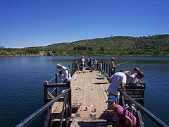 The Small Fry fishing tournament in the Stilling Basin at Lake Meredith
 -
 View from Lake Meredith
 -
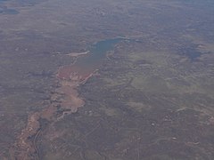 Aerial view


References
- ^ "Listing of acreage – December 31, 2011" (XLSX). Land Resource Division, National Park Service. Retrieved 2012-12-26. ( National Park Service Acreage Reports)
- ^ a b "NPS Annual Recreation Visits Report". National Park Service. Retrieved July 25, 2023.
External links
|
| This National Park Service related article is a stub. You can help Wikipedia by expanding it. |
|
| This article related to a protected area in Texas is a stub. You can help Wikipedia by expanding it. |
- Protected areas of Hutchinson County, Texas
- Protected areas of Moore County, Texas
- National Park Service National Recreation Areas
- Protected areas of Potter County, Texas
- National Park Service areas in Texas
- Protected areas established in 1990
- 1990 establishments in Texas
- National Park Service stubs
- Texas protected area stubs