E25 Kokuritsu-kyōgijō Station 国立競技場駅 | |||||||||||
|---|---|---|---|---|---|---|---|---|---|---|---|
 Exit A5 of Kokuritsu-kyōgijō Station, May 2019. Note the
Tokyo Metropolitan Gymnasium in the background. | |||||||||||
| Japanese name | |||||||||||
| Shinjitai | 国立競技場駅 | ||||||||||
| Kyūjitai | 國立競技場驛 | ||||||||||
| Hiragana | こくりつきょうぎじょうえき | ||||||||||
| General information | |||||||||||
| Location | 10-3 Kasumigaoka-cho,
Shibuya City,
Tokyo Japan | ||||||||||
| Operated by |
| ||||||||||
| Line(s) | E Ōedo Line | ||||||||||
| Platforms | 1 island platform | ||||||||||
| Tracks | 2 | ||||||||||
| Construction | |||||||||||
| Structure type | Underground | ||||||||||
| Accessible | Yes | ||||||||||
| Other information | |||||||||||
| Station code | E-25 | ||||||||||
| History | |||||||||||
| Opened | 12 December 2000 | ||||||||||
| Services | |||||||||||
| |||||||||||
| Location | |||||||||||
 Kokuritsu-Kyōgijō Station Location within Special wards of Tokyo  Kokuritsu-Kyōgijō Station Kokuritsu-Kyōgijō Station (Tokyo Bay and Bōsō Peninsula)  Kokuritsu-Kyōgijō Station Kokuritsu-Kyōgijō Station (Tokyo)  Kokuritsu-Kyōgijō Station Kokuritsu-Kyōgijō Station (Japan) | |||||||||||
Kokuritsu-kyōgijō Station (国立競技場駅, Kokuritsu-kyōgijō-eki, lit. National Stadium Station), also known as Tōkyō Taiikukan-mae, is a Tokyo subway station located in Sendagaya, Shibuya and Shinanomachi, Shinjuku. Situated on the Toei Ōedo Line, the station is operated by the Tokyo Metropolitan Bureau of Transportation.
Lines served
Station layout
The station consists of an island platform serving two tracks. [1]
Platforms
| 1 | E Ōedo Line | for Roppongi and Daimon |
| 2 | E Ōedo Line | for Shinjuku, Tochomae and Hikarigaoka |
-
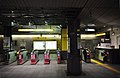 Ticket gates
 -
 Platform 1, April 2018


History
The subway line began full operations on December 12, 2000. [2]
Surrounding area
- Sendagaya Station (1-minute walk)
- Shinanomachi Station (7-minute walk)
- Shinjuku Gyo-en
- Japan National Stadium
- National Noh Theatre (国立能楽堂)
- Hato-no-Mori Hachiman Shrine (鳩森八幡神社)
- Meiji Jingu Skate, Curling Rink and Futsal Courts
- Meiji-Jingu Stadium used by the Japanese baseball team Yakult Swallows
- Chichibunomiya Rugby Stadium
- Tokyo Metropolitan Gymnasium, known as Tokyo Taiikukan in Japanese
- Keio University Medical School Hospital
References
- ^ "Kokuritsu-kyogijo | TOEI TRANSPORTATION". www.kotsu.metro.tokyo.jp. Retrieved 2023-08-25.
- ^ Terada, Hirokazu (July 2002). データブック日本の私鉄 [Databook: Japan's Private Railways]. Japan: Neko Publishing. ISBN 4-87366-874-3.
Wikimedia Commons has media related to
Kokuritsu-Kyōgijō Station.
| International | |
|---|---|
| National | |
35°40′48″N 139°42′51″E / 35.68005°N 139.7141°E
|
| This Tokyo railroad station–related article is a stub. You can help Wikipedia by expanding it. |