From Wikipedia, the free encyclopedia
Inland town of ancient Cilicia
Kanytelis was an inland town of ancient Cilicia, inhabited during the Hellenistic, Roman, and Byzantine eras. [1] Its name does not appear among ancient authors but is inferred from epigraphic and other evidence. [1]
Its site is located near Kanlıdivane in Asiatic Turkey. [1] [2]
References
- ^ a b c Richard Talbert, ed. (2000). Barrington Atlas of the Greek and Roman World. Princeton University Press. p. 66, and directory notes accompanying. ISBN 978-0-691-03169-9.
- ^ Lund University. Digital Atlas of the Roman Empire.
Gallery
-
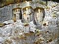
 Detail of a relief in the necropolis.
 -
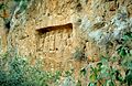
 Rock cut tombs.
 -
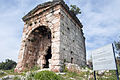 Temple tomb.
 -
 Temple tomb.
 -
 Armaronksas family tomb.
_Ruin,Erdemli,Mersin,Turkey.jpg)


36°31′33″N 34°10′42″E / 36.5259°N 34.17836°E / 36.5259; 34.17836
|
| This article about a location in ancient Cilicia is a stub. You can help Wikipedia by expanding it. |
|
| This article about a populated place in the Byzantine Empire is a stub. You can help Wikipedia by expanding it. |
|
| This geographical article about a location in Mersin Province, Turkey is a stub. You can help Wikipedia by expanding it. |
Retrieved from "
https://en.wikipedia.org/?title=Kanytelis&oldid=1079700334"