Kanlıca | |
|---|---|
 A view of Kanlıca with the
Bosphorus ferry pier and
Fatih Sultan Mehmet Bridge at right | |
 Kanlıca Location in Turkey  Kanlıca Kanlıca (Istanbul) | |
| Coordinates: 41°06′00″N 29°03′57″E / 41.10000°N 29.06583°E | |
| Country | Turkey |
| Province | Istanbul |
| District | Beykoz |
| Population (2022) | 3,943 |
| Time zone | UTC+3 ( TRT) |
| Postal code | 34810 |
| Area code | 0216 |
Kanlıca is a neighbourhood in the municipality and district of Beykoz, Istanbul Province, Turkey. [1] Its population is 3,943 (2022). [2] It is on the Asian side of the Bosphorus strait. [3] It is known for a yogurt sprinkled with caster sugar, which is sold in local cafés, including the İsmailağa Kahvesi which has a small museum commemorating famous visitors of the past. [3]
Location
The Bülbül Creek empties into the Bosphorus at Kanlıca Bay. [3] The Mihrabat Nature Park is situated south of Kanlıca, north of Bülbül Creek.
The İskender Pasha Mosque, commissioned by (military judge) Kazasker Gazi İskender Pasha and originally built by Mimar Sinan in 1559–60, is located inland from Kanlıca Pier. [4] The tomb of İskender Pasha is attached to the old timekeeper's lodge. [5]The mosque has since been rebuilt so that no trace of the Sinan work survives.
The Kanlıca Cemetery is on the hill east of the locality overlooking the Bosphorus. Notable burials of the cemetery include journalist Sedat Simavi, [6] the musicians Barış Manço and Kayahan Açar. [7] [8]
Kanlıca Pier serves the City Ferry Lines ( Turkish: Şehir Hatları) connecting it with Arnavutköy, Bebek, Emirgan, and İstinye on the European shore and Anadoluhisarı, Kandilli and Çengelköy on the Asian shore. [9] Kanlıca Pier is the starting point for the annual Bosphorus Intercontinental Swim, a 6.5 km (4.0 mi)-long open water swimming event across the Strait that finishes at Kuruçeşme on the European side of the city. [10]
A road running inland from Kanlıca Pier leads to the hilltop Khedive's Palace (Hıdiv Kasrı).
History
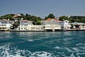
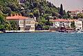
During the Ottoman era, Kanlıca was an upscale neighbourhood, where wealthy people constructed elegant waterfront mansions ( Turkish: Yalı). It is still home to many historic wooden waterfront mansions. [11]
According to Ottoman estimations, in 1882 Kanlica had a population of 9,891, consisting of 6,095 Muslims, 3,043 Greeks, 708 Armenians, 41 Catholics and 4 Latins. [12]
Gallery
-
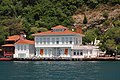 Yalı of ( Grand vizier) Sadrazam Kadri Pasha
 -
 Yalı of Ahmet Rasim Pasha
 -
 Yalı of Hacı Ahmet Bey (second left), Yalı of Ali Mazhar Bey (right), Ethem Pertev Bey Yalısı (rightmost)
 -
 Yalı of Ali Mazhar Bey (left), Yalı of Ethem Pertev Bey (middle)
 -
 Yalı of Elbiseci Ahmet Bey
 -
 Yalı of (Chief Physician) Hekimbaşı Salih Efendi
 -
 Yalı of Yağlıkçı Hacı Reşit Bey (left), Yalı of (Princess) Prenses Rukiye (middle)
 -
 Yalı of Yedi Sekiz Hasan Pasha
 -
-
 Passenger ferry pier of Kanlıca
 -
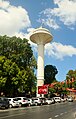 Kanlıca radar tower for marine navigation in Bosphorus
 -
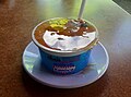 Honey-topped Kanlıca yogurt

_on_the_Bosphorus,_Turkey_001.jpg)


References
- ^ Mahalle, Turkey Civil Administration Departments Inventory. Retrieved 12 July 2023.
- ^ "Address-based population registration system (ADNKS) results dated 31 December 2022, Favorite Reports" (XLS). TÜİK. Retrieved 12 July 2023.
- ^ a b c "A seaside village: Kanlıca". Istanbul. Retrieved 2016-06-11.
- ^ "Kanlıca İskenderpaşa Camii" (in Turkish). İstanbukdaki Camiler. Retrieved 2016-06-12.
- ^ "Kanlıca İskender Paşa Türbesi" (in Turkish). TAS Osmanlı Türbeleri. Retrieved 2016-06-12.
- ^ "Sedat Simavi mezarı başında anıldı". Cumhuriyet (in Turkish). 2008-12-11. Retrieved 2016-06-13.
- ^ Eşit, Elif (2016-01-31). "Barış Manço, mezarı başında dualarla anıldı". Cihan News Agency (in Turkish). Archived from the original on 2016-02-01. Retrieved 2016-06-13.
- ^ "Kayahan Kanlıca Mezarlığı'nda toprağa verilidi". Sabah (in Turkish). 2015-04-04. Retrieved 2016-06-13.
- ^ "Öengelköy-İstinye" (in Turkish). Şehir Hatları. Retrieved 2016-06-12.
- ^ "27. Samsung Boğaziçi ıtalararası Yüzme Yarışı" (in Turkish). İstanbul Yüzme Temsilciliği. 2015-07-27. Archived from the original on 2016-05-14. Retrieved 2016-06-12.
- ^ "Boğazda 55 tarihi yalı yeni sahibini arıyor". Deniz Haber (in Turkish). 2012-08-19. Retrieved 2016-06-11.
- ^ Kemal Karpat (1985), Ottoman Population, 1830-1914, Demographic and Social Characteristics, The University of Wisconsin Press, p. 204-205
| Kadıköy | |
|---|---|
| Üsküdar | |
| Beykoz | |