This article needs additional citations for
verification. (May 2018) |
| Kanaskat-Palmer State Park | |
|---|---|
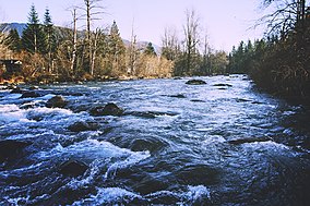
 The
Green River at Kanaskat-Palmer State Park | |
| Location | King, Washington, United States |
| Coordinates | 47°19′03″N 121°54′09″W / 47.31750°N 121.90250°W [1] |
| Area | 320 acres (130 ha) |
| Elevation | 804 ft (245 m) [1] |
| Established | Unspecified |
| Operator | Washington State Parks and Recreation Commission |
| Website | Kanaskat-Palmer State Park |
Kanaskat-Palmer State Park is a 320-acre (130 ha) Washington state park on the Green River in King County. The park has 2 miles (3.2 km) of river shoreline and offers picnicking, camping, 3 miles (4.8 km) of trails for hiking and biking, expert-level rafting and kayaking in the Green River Gorge, fishing, swimming, birdwatching, wildlife viewing, and horseshoes. [2]
References
- ^ a b "Kanaskat-Palmer State Park". Geographic Names Information System. United States Geological Survey, United States Department of the Interior.
- ^ "Kanaskat-Palmer State Park". Washington State Parks and Recreation Commission. Retrieved February 18, 2016.
External links
Wikimedia Commons has media related to
Kanaskat-Palmer State Park.
- Kanaskat-Palmer State Park Washington State Parks and Recreation Commission
- Kanaskat-Palmer State Park Map Washington State Parks and Recreation Commission

