Küçükdalyan | |
|---|---|
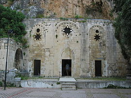
 St Pierre Church of Antakya | |
| Coordinates: 36°13′N 36°10′E / 36.217°N 36.167°E | |
| Country | Turkey |
| Province | Hatay |
| District | Antakya |
| Elevation | 85 m (279 ft) |
| Population (2022) | 10,600 |
| Time zone | UTC+3 ( TRT) |
| Postal code | 31060 |
| Area code | 0326 |
Küçükdalyan is a neighbourhood of the municipality and district of Antakya, Hatay Province, Turkey. [1] Its population is 10,600 (2022). [2] Before the 2013 reorganisation, it was a town ( belde). [3] [4]
Küçükdalyan is situated to the east of Asi River (Orontes of the antiquity) and it is almost merged to Antakya. A part of the town is founded in ancient Antiocheia (Antioch) and is officially declared SIT area (Archaeological site). The Church of St Peter is in the neighbourhood of Küçükdalyan. Küçükdalyan was declared as a seat of township in 1994. Major crops of the town are olive, vegetables and fruits. [5]
References
- ^ Mahalle, Turkey Civil Administration Departments Inventory. Retrieved 19 September 2023.
- ^ "Address-based population registration system (ADNKS) results dated 31 December 2022, Favorite Reports" (XLS). TÜİK. Retrieved 19 September 2023.
- ^ "Law No. 6360". Official Gazette (in Turkish). 6 December 2012.
- ^ "Classification tables of municipalities and their affiliates and local administrative units" (DOC). Official Gazette (in Turkish). 12 September 2010.
- ^ "Mayor's page" (in Turkish). Archived from the original on 2012-11-20. Retrieved 2012-04-10.
