-
 Snowfall in Brooklyn, New York on January 26
 -
 Snowfall in Providence, Rhode Island, on January 27
 -
 Snowfall in Watertown, Massachusetts, on January 27
 -
 Snowfall at the Massachusetts- New Hampshire border before noon on January 27
 -
 Snow covered mailboxes in Boston's Back Bay neighborhood after the January 2015 blizzard
 Satellite image of the blizzard near peak intensity at 06:45Z (1:45 a.m.
EST) on January 27, 2015. | |
| Type |
Extratropical cyclone Winter storm Nor'easter Blizzard |
|---|---|
| Formed | January 23, 2015 |
| Dissipated | January 31, 2015 |
| Highest winds |
|
| Highest gust | 153 km/h (95 mph) [1] |
| Lowest pressure | 970 mb (28.64 inHg) |
| Maximum snowfall or ice accretion | 36.0 in (91 cm) in Lunenburg, Milford, Auburn, and Hudson, and Maynard, Massachusetts |
| Fatalities | 3 total |
| Damage | $500 million (2015 USD) [2] |
| Areas affected | Pacific Northwest, Central United States, Eastern United States, Atlantic Canada, Southern Greenland, Portugal, Spain, France |
Part of the
2014–15 North American winter | |
The January 2015 North American blizzard was a powerful and severe blizzard that dumped up to 3 feet (910 mm) of snowfall in parts of New England. Originating from a disturbance just off the coast of the Northwestern United States on January 23, it initially produced a light swath of snow as it traveled southeastwards into the Midwest as an Alberta clipper on January 24–25. It gradually weakened as it moved eastwards towards the Atlantic Ocean, however, a new dominant low formed off the East Coast of the United States late on January 26, and rapidly deepened as it moved northeastwards towards southeastern New England, producing pronounced blizzard conditions. The nor’easter then gradually weakened as it moved away into Canada. The storm was also given unofficial names, such as Blizzard of 2015, and Winter Storm Juno.
The nor'easter disrupted transportation, with snow emergencies declared in six states and travel bans enacted in four of these states – Connecticut, New Jersey, Massachusetts, and Rhode Island – as well as in New York City. Most passenger rail service was suspended, and thousands of flights were cancelled. [3] [4] Schools and activities saw weather-related cancellations for one or more days.
Before the blizzard struck, meteorologists had been anticipating that the impending storm would be "historic" and "record-breaking", with predictions of snowfall accumulations in major metropolitan areas such as New York City of up to 2–3 feet (24–36 in). However, snowfall fell significantly short of what was anticipated, mainly due to a shift of the storm's track. In the aftermath of the storm, citizens criticized the local government for shutting down the subway system in New York City for the storm.
Meteorological history

Map key
Tropical depression (≤38 mph, ≤62 km/h)
Tropical storm (39–73 mph, 63–118 km/h)
Category 1 (74–95 mph, 119–153 km/h)
Category 2 (96–110 mph, 154–177 km/h)
Category 3 (111–129 mph, 178–208 km/h)
Category 4 (130–156 mph, 209–251 km/h)
Category 5 (≥157 mph, ≥252 km/h)
Unknown
Tropical storm (39–73 mph, 63–118 km/h)
Category 1 (74–95 mph, 119–153 km/h)
Category 2 (96–110 mph, 154–177 km/h)
Category 3 (111–129 mph, 178–208 km/h)
Category 4 (130–156 mph, 209–251 km/h)
Category 5 (≥157 mph, ≥252 km/h)
Unknown
Storm type
On January 23, a low-pressure area developed off the Pacific Northwest, before moving over the Canadian Prairies by January 24. The storm system quickly moved southeastward into the Upper Midwest during the evening of January 24, taking a path typical of an Alberta clipper. [5] [6] As it progressed southward, the storm intensified, with frontogenesis occurring the next day. [7] By noon on January 25, the upper-level low was centered near the border between Iowa and Missouri in correlation with a weak shortwave trough. Moisture from the Gulf of Mexico wrapped around the system from the south, resulting in widespread rainfall and snow over the Midwest. [8] Throughout the day, the system traversed eastward along the Kentucky- Tennessee border. Snowfall remained concentrated along a cold front north of the Ohio River. [9]

At 09:00 UTC on January 26, the Weather Prediction Center began issuing storm summaries on the developing disturbance while the low-pressure system was centered near Bluefield, West Virginia. At the time, mixed precipitation was occurring over northern Appalachia. [10] [11] As this system tracked eastward, it gradually weakened; [12] however, at the same time, a new low-pressure system formed off the coast of North Carolina and began to track north-northeastward, eventually becoming the dominant low of the storm. [13] Early on January 30, the nor'easter left the East Coast, even as another winter storm began to impact the region. [14] During the next day, the former nor'easter continued to accelerate eastward across the North Atlantic, even as it rapidly weakened. [15] On January 31, the winter storm was absorbed by a much more powerful extratropical cyclone developing over Western Europe. [16]
Forecasting controversy
After the storm had passed, a number of New York City residents criticized New York Governor Andrew Cuomo's decision to shut down the city's subway system; it had never previously been closed due to snow. The nor'easter dropped much less snow in the city than originally expected, totaling 9.8 inches (25 cm) in Central Park. The models were 50 miles off; the storm failed to bring moisture back to New York City and New Jersey. [17] [18]
Preparations

On January 25, 2015, blizzard warnings were issued for areas of coastal New England, New York and New Jersey. [19] High winds and heavy snow were forecast for the evening of January 26 and all day January 27, impacting a 250-mile area from New York City to Boston. [3] On January 26, many roads in New York and New England were closed to all vehicles except emergency vehicles due to life-threatening conditions on area roadways. [20]
Many churches and other houses of prayer remained open to those in need of a warming center.[ citation needed]
At the height of the storm, a 300-mile (480 km) stretch of Interstate 95 from northern New Jersey to the Massachusetts/New Hampshire border was closed in conjunction with travel bans in the impacted areas. Portions of Interstates 78, 80, 84, 87, 90, 91 and 93 were also shut down by the storm.[ citation needed]
Pennsylvania
In preparation for the winter storm, the Pennsylvania Department of Transportation deployed approximately 350 salting trucks to treat major roadways. [21] On January 26, Pennsylvania Governor Tom Wolf signed a disaster emergency proclamation in an attempt to distribute state resources as quickly as possible. [22] Philadelphia Mayor Michael Nutter closed municipal offices and schools for January 27 and cancelled trash collection for the day. Meanwhile, SEPTA's bus lines closed while its train system ran 24 hours a day for Monday and Tuesday. According to the Philadelphia Office of Emergency Management, the snow emergency declaration was lifted at 6:00 a.m. Tuesday morning. [23]
New Jersey
The South Brunswick Police Department said in a press release on January 25 that additional officers and public works staff would be on duty throughout the storm. The department urged residents to make preparations in anticipation that travel would be impossible for several days. The Monroe Township Office of Emergency Management released a guideline to ensure residents were safe and prepared for the nor'easter. [24] New Jersey Governor Chris Christie declared a state of emergency for the duration of the storm; in a morning press conference, Christie also urged all nonessential personnel to remain off roadways. [25] A travel ban was issued later that day, to be put in effect on January 26 at 11 pm; Amtrak and New Jersey Transit services were also suspended. [20]
New York

In a statement on January 25, New York Governor Andrew Cuomo urged residents to take their necessary safety precautions and prepare for the possibility of disrupted commute on Monday and Tuesday. The Metropolitan Transportation Authority deployed extra crews, salting trucks, and chained tires. Delta Air Lines promised full refunds for flights significantly delayed. [26] The State Emergency Operations Center in Albany was expected to be staffed beginning early on January 26 to coordinate with all affected counties. At least 1,806 plows and 126,000 tons of salt were expected to be divided across the region, and the National Guard was expected to deploy more than six dozen personnel and 20 vehicles throughout the region. New York State Police were expected to bring in additional personnel, as well as supply at least 50 4x4 vehicles, 8 all-terrain vehicles, and 8 snowmobiles.
At its major transportation facilities, the Port Authority of New York and New Jersey readied more than 200 piece of snow equipment at its airports, more than 60 pieces of snow equipment for its bridges and tunnels, hundreds of thousands of gallons of liquid anti-icer chemicals and thousands of tons of solid de-icers, plow-equipped trains, liquid snow-melting agent trains, and a "jet engine" plow. The New York State Thruway Authority activated its emergency operations ahead of the winter storm and was expected to supply 338 snowplows, 18 snowblowers, 55 front-end loaders, and approximately 126,000 tons of salt. The New York State Department of Transportation also activated its emergency operations, mobilizing 162 snow plows and nearly 338 operators to Long Island and the Hudson Valley, totaling to approximately 600 plows and 1,300 operators and supervisors across downstate New York. A total of 1,444 snow plows and 3,629 operators and supervisors would be available statewide. [27]
New York City Mayor Bill de Blasio warned of 2 to 3 feet (0.61 to 0.91 m) of snow, and said, "Prepare for something worse than we have seen before." [28] De Blasio ordered all vehicles off the streets by 11 pm on January 26, and declared that, with the exception of emergency and government vehicles, anyone driving in New York City after 11 pm on January 26 would be fined. Services on the New York City Subway, Long Island Rail Road, Metro-North Railroad, and Amtrak were also suspended. [20]
Connecticut
Connecticut Governor Dannel Malloy announced in a press conference early on January 26 that Connecticut Transit services would be suspended and a statewide travel ban would be effective beginning at 9 p.m. EST; he also urged all residents to leave work early and shelter in their homes. The Metropolitan Transportation Authority announced that it would be adding additional trains to accommodate for those who travel by rail. The governor announced that more than 600 crews would be working to pre-treat major roads, while he issued a declaration of civil preparedness emergency to coordinate resources during the storm. [29] Connecticut Light and Power and United Illuminating prepared for a "Level 1" emergency and summoned outside tree and line crews. [30] Later that day, the governor declared a state of emergency. The travel ban was lifted for Fairfield and Litchfield Counties in western Connecticut at 8 a.m. on the 27th, and for the remainder of the state at 2 p.m. that afternoon. [31]
Rhode Island
Rhode Island Governor Gina Raimondo urged people to ensure that they had enough food, water, and fuel to last several days for what could be a "very severe and dangerous weather event". She asked residents to keep fire hydrants uncovered and asked that generators used for electricity were located outside of homes and in well-ventilated locations. [32] On January 26, the governor declared a state of emergency and announced that a statewide travel ban would go into effect at midnight. National Grid gathered approximately 1,000 crews to help restore power after the storm passed. [33]
Massachusetts

Massachusetts Governor Charlie Baker declared a state of emergency and asked residents to remain safe and off roadways. A statewide travel ban was issued effective at midnight on January 27, and the Massachusetts Bay Transportation Authority announced that it would be closed that day. In Boston, up to 35,000 tons of salt were prepared and snow farms were readied to store the removed snow following the passage of the storm. Electric companies brought in extra crews. [34] The Fall River, Massachusetts Department of Public Works gathered more than 800 tons of salt and began to treat major roadways in advance of the storm. [35]
Atlantic Canada
Environment Canada issued special weather statements to all of the Maritime provinces on January 23, warning of the future developing storm. On January 26 Environment Canada issued Winter Storm Warnings for all of Nova Scotia, Prince Edward Island, and central to southern New Brunswick. These warnings were later upgraded to Blizzard Warnings. Between 6 and 20 inches (15 and 51 cm) of snow was forecast across the Maritimes. On January 27, snow started early in the morning in southwestern Nova Scotia and continued northeastward. A large wind gust of 80 mph (130 km/h) was measured in Baccaro Point, NS. [36] Meanwhile, in Sluice Point there were gusts exceeding 70 mph (110 km/h) in the afternoon. [37] In Moncton snow totaled near 11.8 inches (30 cm) the most out of all four provinces. [38] The strong winds and blowing snow caused poor traveling conditions across Atlantic Canada.
Impact
Mid-Atlantic states
FlightAware reported that 1,200 flights were expected to be cancelled on January 26. [3] Delta pre-emptively cancelled 600 flights; furthermore, a dozen flights from London Heathrow to New York, Philadelphia and Boston were cancelled on the same date. [4]
At least two deaths related to the nor'easter occurred on Long Island, New York. Sean Urda, a 17-year-old student from John Glenn High School, was killed when he struck a light pole while snow tubing with two other people in Huntington. [39] An 83-year-old man with dementia was found dead in his backyard in Bay Shore. [40]
The National Basketball Association postponed two games scheduled to take place on January 26, both in New York City. The game between the Portland Trail Blazers and the Brooklyn Nets was rescheduled for April 6, while the game between the Sacramento Kings and the Manhattan-based New York Knicks was rescheduled for March 3. [41]
Snow from the storm fell as far south as parts of North Carolina, southern Virginia, [42] Washington, D.C., and the Washington, D.C. metropolitan area, where trace amounts were reported beginning on January 26. [43] Schools in some Virginia counties were closed due to the weather. [42] [44]
New England
A record-breaking 22.1 inches of snow fell in Boston on January 27. [45]
WWE had events scheduled to take place in Hartford, Connecticut, and in Boston, Massachusetts, but had to cancel them, instead choosing to air Royal Rumble highlights.
Significant flooding was reported in Scituate, Massachusetts, where National Guardsmen were sent to rescue people from the high waters [46] and power was cut to some areas of the town to prevent fires from breaking out. [47] Elsewhere in the state, eighty feet of seawall in Marshfield was washed away by the storm, and a number of houses in the town were condemned. [48] "Virtually all" utility customers lost power on the island of Nantucket and in Provincetown on Cape Cod during the storm. [49]
A replica of the USS Providence, maintained by the Providence Maritime Heritage Foundation and designated in 1992 as the flagship and tall ship ambassador of the state of Rhode Island, was toppled and severely damaged by high winds during the storm while in drydock for the winter. [50]
Gallery
Images of snowfall accumulated during the blizzard


Records
Up to 34.5 in (88 cm) of snow fell in Worcester, Massachusetts, marking the city's largest storm total accumulation on record. The Blue Hill Observatory in Massachusetts observed 30.8 in (78 cm), or the second-largest storm total accumulation on record, while both Providence, Rhode Island and Portland, Maine recorded their fourth-largest storm total accumulations on record, at 19.1 in (49 cm). Boston observed 24.6 in (62 cm) of snow, its largest January storm total accumulation and its sixth largest storm total accumulation on record. [51]
Snowfall totals
The following is a list of storm totals above 24 inches (61 cm). Click "hide" to collapse table.
| Amount | City/location | State |
|---|---|---|
| 36.0 inches (91 cm) | Lunenburg | MA |
| 36.0 inches (91 cm) | Auburn | MA |
| 36.0 inches (91 cm) | Hudson | MA |
| 36.0 inches (91 cm) | Milford | MA |
| 36.0 inches (91 cm) | Oxford | MA |
| 34.5 inches (88 cm) | Worcester | MA |
| 34.4 inches (87 cm) | East Sandwich | MA |
| 34.1 inches (87 cm) | Clinton | MA |
| 34.1 inches (87 cm) | 0.2 Miles North of Winthrop | CT |
| 33.8 inches (86 cm) | Chelmsford | MA |
| 33.5 inches (85 cm) | Thompson | CT |
| 33.5 inches (85 cm) | West Boylston | MA |
| 33.5 inches (85 cm) | Framingham | MA |
| 33.2 inches (84 cm) | Nashua | NH |
| 33.1 inches (84 cm) | Dracut | MA |
| 33.0 inches (84 cm) | Acton | MA |
| 32.8 inches (83 cm) | 1.3 Miles Southwest of Acton | CT |
| 32.5 inches (83 cm) | Brewster | MA |
| 32.3 inches (82 cm) | 0.6 Miles East of Southbridge | CT |
| 32.0 inches (81 cm) | Hudson | NH |
| 32.0 inches (81 cm) | Holden | MA |
| 31.5 inches (80 cm) | West Harwich | MA |
| 31.5 inches (80 cm) | Methuen | MA |
| 31.5 inches (80 cm) | 1.2 Miles Northeast of North Waterboro | ME |
| 31.0 inches (79 cm) | South Boston | MA |
| 31.0 inches (79 cm) | Sharon | MA |
| 31.0 inches (79 cm) | Gloucester | MA |
| 31.0 inches (79 cm) | Milford | MA |
| 30.7 inches (78 cm) | Plymouth | MA |
| 30.0 inches (76 cm) | Orient | NY |
| 30.0 inches (76 cm) | Putnam | CT |
| 29.0 inches (74 cm) | Southampton | NY |
| 28.5 inches (72 cm) | Burrillville | RI |
| 27.1 inches (69 cm) | Hyannis | MA |
| 27.0 inches (69 cm) | Oak Bluffs | MA |
| 26.9 inches (68 cm) | Mattituck | NY |
| 26.2 inches (67 cm) | Shrewsbury | MA |
| 26.0 inches (66 cm) | East Freetown | MA |
| 25.6 inches (65 cm) | Medford | NY |
| 25.6 inches (65 cm) | Tewksbury | MA |
| 25.0 inches (64 cm) | Cumberland | ME |
| 24.6 inches (62 cm) | 1 Mile North of East Boston (Airport) | MA |
| 24.5 inches (62 cm) | Quincy | MA |
| 25.6 inches (65 cm) | West Gloucester | RI |
| 24.1 inches (61 cm) | Fall River | MA |
| 24.0 inches (61 cm) | Groton | CT |
| 24.0 inches (61 cm) | West Babylon | NY |
| 24.0 inches (61 cm) | Hanover | MA |
| 24.0 inches (61 cm) | Marshfield | MA |
| 24.0 inches (61 cm) | Wells | ME |
| 24.0 inches (61 cm) | Auburn | NH |
Disaster relief funds
In April 2015, President Obama made a federal disaster declaration for the January 26–27 snow, allowing some reimbursement for damages. [56] Massachusetts distributed an extra $30 million to cities and towns for repairs from the winter overall. [57]
See also
Wikimedia Commons has media related to
Winter Storm Juno.
- North American blizzard of 2003 – A crippling blizzard that struck the Mid-Atlantic and Northeast in February 2003
- North American blizzard of 2006 – A blizzard that delivered a record-breaking snowfall total of 26.9 in (68 cm) to New York City
- December 2010 North American blizzard
- February 2013 North American blizzard – A significant winter storm that affected the Northeastern United States in February 2013
References
- ^ "Winter Storm Juno Hammering New England". The Weather Channel. January 26, 2015. Retrieved January 27, 2015.
- ^ Global Catastrophe Recap - January 2015, Aon, February 2015
- ^ a b c Verena Dobnik (January 26, 2015). "Nor'easter threatens Northeast with up to 2 feet of snow". AOL. Associated Press. Retrieved January 26, 2015.
- ^ a b "Weather NYC: Thousands of transatlantic travellers face serious disruption caused by New York winter storm 'Juno'". The Independent. January 26, 2015. Retrieved January 26, 2015.
- ^ Rubin-Oster, Brenden (January 24, 2015). "Short Range Public Discussion Jan 24 2015 335 AM EST". Weather Prediction Center. College Park, Maryland: United States National Weather Service. Archived from the original on January 26, 2015. Retrieved January 26, 2015.
- ^ Petersen, Daniel (January 23, 2015). "Probabilistic Heavy Snow And Icing Discussion Jan 23 2015 3:17AM EST". College Park, Maryland: Weather Prediction Center. Archived from the original on February 3, 2015. Retrieved January 26, 2015.
- ^ Petersen, Daniel (January 24, 2015). "Probabilistic Heavy Snow And Icing Discussion Jan 24 2015 3:49AM EST". College Park, Maryland: Weather Prediction Center. Archived from the original on February 3, 2015. Retrieved January 26, 2015.
- ^ Office of Satellite and Product Operation (January 25, 2015). "Satellite Precipitation Estimates Jan 25 2015 1545Z". National Environmental Satellite, Data, and Information Service. National Oceanic and Atmospheric Administration. Retrieved January 26, 2015.
- ^ Office of Satellite and Product Operation (January 25, 2015). "Satellite Precipitation Estimates Jan 25 2015 1945Z". National Environmental Satellite, Data, and Information Service. National Oceanic and Atmospheric Administration. Retrieved January 26, 2015.
- ^ Fanning, Amanda (January 26, 2015). "Storm Summary Number 01 For Mid-Atlantic To Northeast Major Winter Storm". Weather Prediction Center. College Park, Maryland: National Centers for Environmental Prediction. Archived from the original on October 31, 2015. Retrieved January 26, 2015.
- ^ Office of Satellite and Product Operation (January 26, 2015). "Satellite Precipitation Estimates Jan 26 2015 0915Z". National Environmental Satellite, Data, and Information Service. National Oceanic and Atmospheric Administration. Retrieved January 26, 2015.
- ^ Petersen, Daniel (January 26, 2015). "Probabilistic Heavy Snow And Icing Discussion Jan 26 2015 4:07AM EST". College Park, Maryland: Weather Prediction Center. Archived from the original on January 23, 2015. Retrieved January 26, 2015.
- ^ Kong, Kwan-yin (January 26, 2015). "Storm Summary Number 02 For Mid-Atlantic To Northeast Major Winter Storm". Weather Prediction Center. College Park, Maryland: National Centers for Environmental Prediction. Archived from the original on October 31, 2015. Retrieved January 26, 2015.
- ^ "Winter Storm Kari Blankets Snow-Weary New England". The Weather Channel. January 29, 2015.
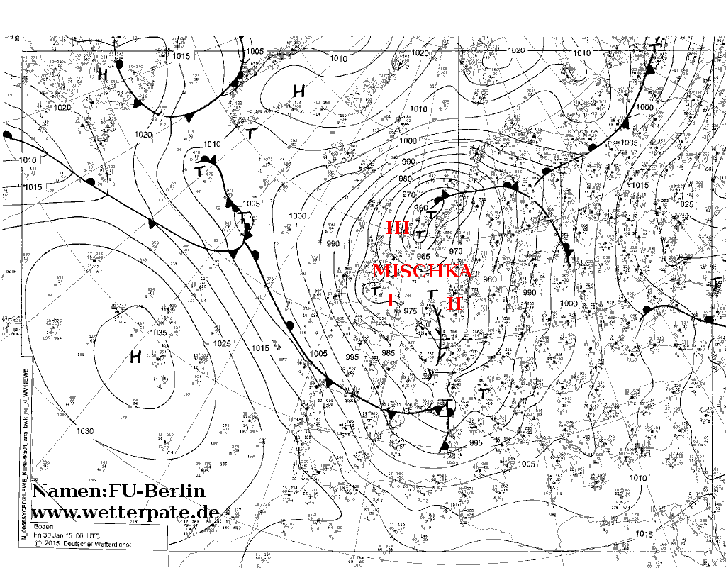
- ^ "Fu-Berlin Map" (gif). January 30, 2015. Retrieved March 1, 2015.
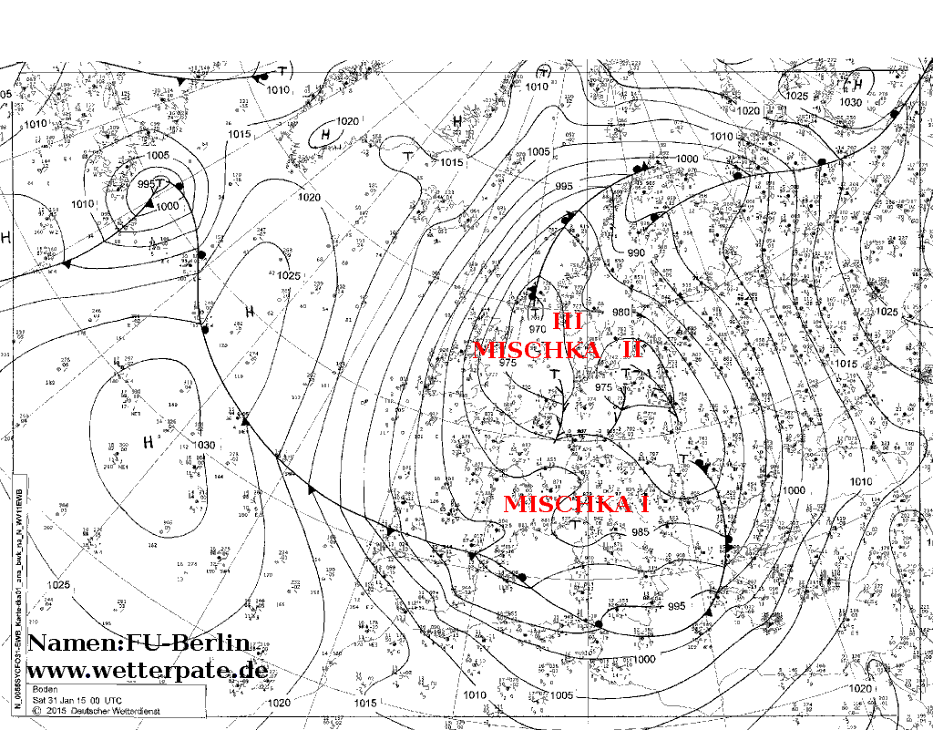
- ^ "Fu-Berlin Map" (gif). January 31, 2015. Retrieved March 1, 2015.
- ^ Flegenheimer, Matt (January 27, 2015). "Leaders in New York and New Jersey Defend Shutdown for a Blizzard That Wasn't". New York Times. Retrieved January 28, 2015.
- ^ Dolce, Chris; Lam, Linda; Wiltgen, Nick. "Juno: Heavy Snow Continues in New England". Weather.com. The Weather Channel, LLC. Retrieved January 28, 2015.
- ^ Linda Lam; Chris Dolce (January 26, 2015). "Winter Storm Juno: Blizzard Warnings for New York City, Boston, Parts of 7 States; Potentially Historic Northeast Snowstorm Ahead". The Weather Channel. Retrieved January 26, 2015.
- ^ a b c Marc Santora (January 26, 2015). "Snowstorm Barrels Into Northeast; New York City Subways and Buses Are Halted". The New York Times. Retrieved January 26, 2015.
- ^ "NWS: 18–24 inches for Burlington and Lower Bucks; 14–18 for parts of Bucks, Montco". Burlington County Times. January 25, 2015. Retrieved January 25, 2015.
- ^ Howard Sheppard (January 26, 2015). "Governor signs disaster emergency proclamation". Fox 43 News. Retrieved January 26, 2015.
- ^ Berger, Michele; Bonaccorso, N. (January 27, 2015). "Philadelphia, Mid-Atlantic States: Less Snow Than Expected from Juno". The Weather Channel. Retrieved January 27, 2015.
- ^ Charles Kim (January 25, 2015). "Region prepares for possible blizzard". Central Jersey. Retrieved January 25, 2015.
- ^ Susan Livio (January 26, 2015). "Christie declares state of emergency for N.J. blizzard, urges residents to stay home". NJ Advance Media. Retrieved January 26, 2015.
- ^ "Going Somewhere? Planes, Trains and Automobiles Prep for Blizzard". A Breaking News. January 25, 2015. Retrieved January 25, 2015.
- ^ "Governor Cuomo Urges New Yorkers to Prepare for Major Snowstorm Forecasted to Hit Downstate Areas on Monday and Tuesday". Albany, New York: New York State. January 25, 2015. Retrieved January 25, 2015.
- ^ Major Nor'easter to Disrupt Travel for Millions Bringing Heavy Snow and Blizzard Conditions ABC News, January 25, 2015
- ^ "Travel Ban Issued, Schools Dismiss in Advance of Blizzard". NBC Connecticut. January 26, 2015. Retrieved January 26, 2015.
- ^ "Governor Orders Travel Ban As of 9 p.m." CBS Connecticut. January 26, 2015. Retrieved January 26, 2015.
- ^ Jim Levulis (January 26, 2015). "MA And CT Declare State Of Emergency, Issues Travel Bans As Winter Blast Nears". WAMC Northeast Public Radio. Retrieved January 26, 2015.
- ^ "RI governor: Prepare for possible dangerous weather event". Associated Press. January 25, 2015. Retrieved January 25, 2015.
- ^ Dee DeQuattro (January 26, 2015). "Raimondo announces State of Emergency for RI". ABC 6 News. Retrieved January 26, 2015.
- ^ "State of emergency declared; travel ban imposed in Massachusetts". WCVB 5 News. January 26, 2015. Retrieved January 26, 2015.
- ^ Colin Spence (January 26, 2015). "SE Massachusetts makes preparations for blizzard". WPRI 12 News. Fall Rivers, Massachusetts. Retrieved January 26, 2015.
- ^ "Weather Data". Environment Canada. Retrieved January 27, 2015.
- ^ "Weather data". wunderground. Retrieved January 27, 2015.
- ^ "Snowstorm hits the Maritimes". Global News. Retrieved January 27, 2015.
- ^ "1st death of storm reported: Teen dies after sledding accident". WCVB. January 27, 2015.
- ^ "Bay Shore man, 83, found dead on Long Island, police say". Newsday. Retrieved January 28, 2015.
- ^ NBA POSTPONES TONIGHT’S GAMES IN NEW YORK AREA DUE TO WEATHER CONDITIONS National Basketball Association.com (01/26/2015)
- ^ a b "Snow closes schools, causes wrecks goes away quickly". Richmond.com. Retrieved January 28, 2015.
- ^ "D.C. area forecast: Tricky storm brings snow tonight into Monday, cold start to the week". Washington Post. Retrieved January 28, 2015.
- ^ "Mid-Atlantic dealt 'glancing blow,' avoids worst of storm". stardem.com. Retrieved January 28, 2015.
- ^ Fritz, Angela (February 3, 2015). "Boston's record-setting snow blitz — a winter's worth of snow in less than 10 days". Washington Post. ISSN 0190-8286. Retrieved September 24, 2021.
- ^ "National Guard rescues Scituate residents". Boston Globe. Retrieved January 28, 2015.
- ^ "Massachusetts Town of Scituate Cuts Power to Prevent Flood Fires". NBC News. Retrieved January 28, 2015.
- ^ Erin Smith (January 27, 2015). "Scenes from Juno: Marshfield seawall crumbling, homes condemned". bostonherald.com. Retrieved January 28, 2015.
- ^ Fitzgerald, Jay (January 27, 2015). "Utilities emerge from storm with fewer outages than feared". Boston Globe. Retrieved January 28, 2015.
- ^ "USS Providence damaged after falling in storm's strong winds". Stars and Stripes. Retrieved January 28, 2015.
- ^ Jeffrey Masters; Bob Henson (January 28, 2015). "Blizzard of 2015 brings 2–3' of Snow and Questions About Forecast Accuracy". Weather Underground. Weather Underground. Retrieved January 28, 2015.
- ^ "Storm Reports: 2 Feet of Snow, 70 mph Winds". The Weather Channel. January 26, 2015.
- ^ "How Did East Coast Blizzard of 2015 Play Out?". accuweather.com. January 30, 2015.
- ^ "National Weather Service – Eastern Region Hydrometeorological Event Display". noaa.gov.
- ^ "Public Information Statement Spotter Reports National Weather Service Taunton MA". weather.gov.
- ^ "Obama approves Massachusetts disaster declaration for first snowstorm only". April 14, 2015.
- ^ "Winter Recovery Assistance Program Announced". www.mass.gov. Archived from the original on March 24, 2015.
External links
- Event Review from the Weather Prediction Center
- "10 weird things Americans are doing in the snow", BBC News, February 26, 2015
Categories:
- Blizzards in the United States
- Blizzards in Canada
- Nor'easters
- 2014–15 North American winter
- 2015 natural disasters in the United States
- 2015 disasters in Canada
- Natural disasters in Connecticut
- Natural disasters in Maine
- Natural disasters in Massachusetts
- Natural disasters in New Hampshire
- Natural disasters in New York (state)
- Natural disasters in New Jersey
- Natural disasters in Pennsylvania
- Natural disasters in Rhode Island
- Natural disasters in Vermont
- 2015 in Connecticut
- 2015 in Maine
- 2015 in Massachusetts
- 2015 in New Hampshire
- 2015 in New York (state)
- 2015 in New Jersey
- 2015 in Pennsylvania
- 2015 in Rhode Island
- 2015 in Vermont
- January 2015 events in the United States
- February 2015 events in the United States