(Redirected from
Iron Point (Sacramento RT))
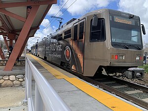
 SacRT Gold Line trainset at Iron Point Station | |||||||||||
| General information | |||||||||||
| Location | Folsom Boulevard and Iron Point Road Folsom, California United States | ||||||||||
| Coordinates | 38°38′41″N 121°11′25″W / 38.64472°N 121.19028°W | ||||||||||
| Owned by | Sacramento Regional Transit District | ||||||||||
| Platforms | 1 side platform | ||||||||||
| Tracks | 1 | ||||||||||
| Connections |
| ||||||||||
| Construction | |||||||||||
| Structure type | At-grade | ||||||||||
| Parking | 216 spaces [3] | ||||||||||
| Accessible | Yes | ||||||||||
| History | |||||||||||
| Opened | October 15, 2005 [4] | ||||||||||
| Services | |||||||||||
| |||||||||||
| Location | |||||||||||
|
| |||||||||||
Iron Point station is a side platformed Sacramento RT Light Rail station in Folsom, California, United States. The station was opened on October 15, 2005, and is operated by the Sacramento Regional Transit District. It is served by the Gold Line. The station is located near the intersection of Folsom Boulevard and Iron Point Road, for which the station is named, and serves the Folsom Premium Outlets shopping center.
Platforms and tracks
| Westbound/ Eastbound |
←
Gold Line toward
Sacramento Valley Station (
Hazel) Gold Line toward Historic Folsom ( Glenn) → |
| Side platform, doors open on the right | |
References
- ^ "SacRT System Map" (PDF) (Map). Sacramento Regional Transit District. August 29, 2021. Retrieved April 30, 2023.
- ^ "50 Express". El Dorado Transit. Retrieved May 1, 2023.
- ^ "Park-and-Ride Lots". Sacramento Regional Transit District. Retrieved April 30, 2023.
- ^ Sangree, Hudson (October 16, 2005). "'All aboard' as Folsom says hello to light rail – It's a commuter alternative to Hwy. 50". The Sacramento Bee. p. B1.