| Ibi-Sekigahara-Yōrō Quasi-National Park | |
|---|---|
| 揖斐関ヶ原養老国定公園 | |
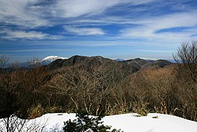
 View from
Mount Yōrō | |
Map of
Japan | |
| Location | Gifu Prefecture, Japan |
| Coordinates | 35°28′16″N 136°23′31″E / 35.471°N 136.392°E [1] |
| Area | 202.19 km2 (78.07 sq mi) |
| Established | 28 December 1970 |
Ibi-Sekigahara-Yōrō Quasi-National Park (揖斐関ヶ原養老国定公園, Ibi-Sekigahara-Yōrō Kokutei Kōen) is a Quasi-National Park in southwest Gifu Prefecture, Japan. The park was established in 1970. [2] [3] [4] [5]
Attractions
Ibi Gorge ( 揖斐峡), Ibi River, Kegon-ji ( 華厳寺), Mount Ikeda, Mount Yōrō, Sekigahara Battlefield, Tōkai Nature Trail, Yōrō Falls [5]
Related municipalities
Ibigawa, Ikeda, Kaizu, Motosu, Ōgaki, Sekigahara, Tarui, Yōrō [4]
See also
Wikimedia Commons has media related to
Ibi-Sekigahara-Yōrō Quasi-National Park.
References
- ^ "Ibi - Sekigahara -Yoro Quasi National Park". protectedplanet.net.
- ^ "天竜奥三河/揖斐関ヶ原養老/飛騨木曽川/愛知高原". National Parks Association of Japan. Archived from the original on 18 September 2011. Retrieved 28 February 2012.
- ^ "List of Quasi-National Parks" (PDF). Ministry of the Environment. Retrieved 28 February 2012.
- ^ a b "Natural Parks of Gifu Prefecture" (in Japanese). Gifu Prefecture. Archived from the original on 27 July 2012. Retrieved 28 February 2012.
- ^ a b "Quasi-National Parks of Gifu Prefecture" (in Japanese). Gifu Prefecture. Retrieved 28 February 2012.
