Parts of this article (those related to demographics) need to be updated. (July 2023) |
Harrisville, New Hampshire | |
|---|---|
Town | |
 The historic mill village of Harrisville | |
 Location in
Cheshire County, New Hampshire | |
| Coordinates: 42°56′42″N 72°05′47″W / 42.94500°N 72.09639°W | |
| Country | United States |
| State | New Hampshire |
| County | Cheshire |
| Incorporated | 1870 |
| Villages | |
| Government | |
| • Board of Selectmen |
|
| Area | |
| • Total | 20.2 sq mi (52.4 km2) |
| • Land | 18.6 sq mi (48.3 km2) |
| • Water | 1.6 sq mi (4.1 km2) 7.79% |
| Elevation | 1,335 ft (407 m) |
| Population (2020)
[2] | |
| • Total | 984 |
| • Density | 53/sq mi (20.4/km2) |
| Time zone | UTC-5 ( Eastern) |
| • Summer ( DST) | UTC-4 ( Eastern) |
| ZIP code | 03450 |
| Area code | 603 |
| FIPS code | 33-34420 |
| GNIS feature ID | 0873620 |
| Website |
www |
Harrisville is a town in Cheshire County, New Hampshire, United States. Besides the town center, it also includes the villages of Chesham and Eastview. The population of the town was 984 at the 2020 census. [2]
It is a preserved 19th-century mill town located in the Monadnock region of southern New Hampshire. There are nine bodies of water in the town, many back roads and trails to explore, and two original train depots at Harrisville and Chesham.
History
First known as "Twitchell's Mills", a combination sawmill and gristmill was built here in 1774. The town of Harrisville was formed in 1870 from lands ceded by Marlborough, Dublin, Hancock, Nelson, and Roxbury. The Manchester & Keene Railroad opened in 1878, helping it prosper as a textile mill town. [3] It was named for Milan Harris, whose stone and brick Cheshire Mills operated until 1970, but look virtually unchanged since the mid-19th century. [4]
Today, the Cheshire Mills are protected as part of the Harrisville Historic District, a National Historic Landmark which includes the center of town. With its red brick buildings and mills reflected in Harrisville Pond and canal, the village is frequently photographed as an iconic example of picturesque old New England. [5] The Harrisville Rural District includes the southern part of the town near the Dublin border.
-
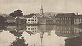 Town view c. 1905
 -
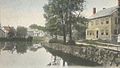 Looking up canal in 1914
 -
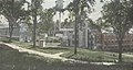 Cheshire Mills c. 1915


Geography
According to the United States Census Bureau, the town has a total area of 20.2 square miles (52.4 km2), of which 18.6 square miles (48.3 km2) are land and 1.6 square miles (4.1 km2) are water, comprising 7.79% of the town. [1] The highest point in Harrisville is the summit of Cobb Hill, at 1,909 feet (582 m) above sea level. Roughly the western half of Harrisville, drained by Minnewawa Brook, lies within the Ashuelot River watershed, part of the Connecticut River basin, while the eastern half, drained by Nubanusit Brook, is in the Contoocook River watershed, part of the Merrimack River basin. [6] Significant water bodies include Silver Lake, Seaver Reservoir, and Chesham Pond on the western side, and Harrisville Pond and Skatutakee Lake draining to the east. [7]
Adjacent municipalities
- Nelson (north)
- Hancock (east)
- Peterborough (southeast)
- Dublin (south)
- Marlborough (southwest)
- Roxbury (west)
Churches
The Community Church of Harrisville and Chesham was formed from Chesham Baptist Church and Harrisville Congregational Church. Chesham Baptist Church dates back to 1785. The church building was originally built in 1797, re-modeled in 1830, and again re-modeled in 1844. The Evangelical Congregational Church of Harrisville dates back to 1840, and the church building was erected in 1840–1843.
The Community Church is a member of the United Church of Christ (UCC) and the American Baptist Association, and it retains a united congregation using only the brick church in Harrisville village. The church in Chesham is owned by the American Baptist Association of Vermont & New Hampshire and is no longer used by the Community Church of Harrisville & Chesham.
Harrisville was home to St. Denis Parish of the Roman Catholic Church from 1902 to 2010, when services ended following the merger with Saint Peter Parish in Peterborough and Saint Patrick Parish in Bennington. [8] The church building is now owned by Historic Harrisville and is referred to as St. Denis Hall. [9]
Demographics
| Census | Pop. | Note | %± |
|---|---|---|---|
| 1880 | 870 | — | |
| 1890 | 748 | −14.0% | |
| 1900 | 791 | 5.7% | |
| 1910 | 623 | −21.2% | |
| 1920 | 559 | −10.3% | |
| 1930 | 512 | −8.4% | |
| 1940 | 509 | −0.6% | |
| 1950 | 519 | 2.0% | |
| 1960 | 459 | −11.6% | |
| 1970 | 584 | 27.2% | |
| 1980 | 860 | 47.3% | |
| 1990 | 981 | 14.1% | |
| 2000 | 1,075 | 9.6% | |
| 2010 | 961 | −10.6% | |
| 2020 | 984 | 2.4% | |
| U.S. Decennial Census [2] [10] | |||
At the 2000 census, [11] there were 1,075 people, 449 households and 306 families residing in the town. The population density was 57.4 per square mile (22.2/km2). There were 698 housing units at an average density of 37.2 per square mile (14.4/km2). The racial make-up of the town was 97.77% White, 0.09% African American, 0.56% Native American, 0.28% Asian and 1.30% from two or more races. Hispanic or Latino of any race were 0.56% of the population.
There were 449 households of which 31.2% had children under the age of 18 living with them, 55.2% were married couples living together, 8.9% had a female householder with no husband present and 31.8% were non-families. 26.5% of all households were made up of individuals and 7.8% had someone living alone who was 65 years of age or older. The average household size was 2.39 and the average family size was 2.87.
24.8% of the population were under the age of 18, 4.6% from 18 to 24, 25.7% from 25 to 44, 30.0% from 45 to 64 and 15.0% were 65 years of age or older. The median age was 43 years. For every 100 females, there were 92.3 males. For every 100 females age 18 and over, there were 87.0 males.
The median household income was $48,625 and the median family income was $55,083. Males had a median income of $34,625 and females $27,171. The per capita income was $25,397. About 4.3% of families and 5.7% of the population were below the poverty line, including 8.0% of those under age 18 and 3.8% of those age 65 or over.
Education
The elementary school is Wells Memorial School in Chesham.
References
- ^ a b "2021 U.S. Gazetteer Files – New Hampshire". United States Census Bureau. Retrieved November 3, 2021.
- ^ a b c "Harrisville town, Cheshire County, New Hampshire: 2020 DEC Redistricting Data (PL 94-171)". U.S. Census Bureau. Retrieved November 3, 2021.
- ^ Harrisville Railroad Depot, Harrisville, New Hampshire
- ^ History of Harrisville, Cheshire County, New Hampshire
- ^ "History of Harrisville". Archived from the original on March 25, 2006. Retrieved March 16, 2006.
- ^ Foster, Debra H.; Batorfalvy, Tatianna N.; Medalie, Laura (1995). Water Use in New Hampshire: An Activities Guide for Teachers. U.S. Department of the Interior and U.S. Geological Survey.
- ^ U.S. Geological Survey. Dublin, NH 1:25,000-scale quadrangle, 1984
- ^ Decree Archived 2014-05-12 at the Wayback Machine "Merging Saint Peter Parish in Peterborough, New Hampshire, Saint Patrick Parish in Bennington, New Hampshire and Saint Denis Parish in Harrisville, New Hampshire, to form one new canonical person", Diocese of Manchester NH, June 25, 2006.
- ^ St. Denis Catholic Church, Historic Harrisville.
- ^ "Census of Population and Housing". Census.gov. Retrieved June 4, 2016.
- ^ "U.S. Census website". United States Census Bureau. Retrieved January 31, 2008.
External links
- Official website
- Harrisville Public Library
- New Hampshire Economic and Labor Market Information Bureau profile
- Historical information from Access Genealogy
Places adjacent to Harrisville, New Hampshire | ||||||||||||||||
|---|---|---|---|---|---|---|---|---|---|---|---|---|---|---|---|---|
| ||||||||||||||||
Municipalities and communities of
Cheshire County, New Hampshire, United States | ||
|---|---|---|
| City |  | |
| Towns | ||
| CDPs | ||
| Other villages | ||
| International | |
|---|---|
| National | |