 Hams Bluff Light (historic photo) | |
|
| |
| Location |
Saint Croix U.S. Virgin Islands |
|---|---|
| Coordinates | 17°46′9.0″N 64°52′15.1″W / 17.769167°N 64.870861°W |
| Tower | |
| Constructed | 1915 (first) |
| Foundation | concrete base |
| Construction | cast iron tower (first) metal skeletal tower (current) |
| Height | 35 feet (11 m) (first) 30 feet (9.1 m)(current) |
| Shape | conical tower with balcony and lantern (first) square prism skeletal tower (current) |
| Markings | white tower (current) |
| Operator | United States Navy [1] |
| Heritage | National Register of Historic Places listed place
|
| Light | |
| First lit | 2010 (current) |
| Deactivated | 2010 |
| Focal height | 394 feet (120 m) (current) |
| Range | 16 nautical miles (30 km; 18 mi) |
| Characteristic | Fl (2) W 30s. |
Hans Bluff Light | |
| Area | less than one acre |
| NRHP reference No. | 100004382 |
| Added to NRHP | September 16, 2019 |
The Hams Bluff Light is an historic lighthouse on Saint Croix, U.S. Virgin Islands. It was first lit in 1915 under the Danish Government. It was since transferred to the United States Lighthouse Service and later came under the jurisdiction of the United States Coast Guard. The historic tower has been abandoned; the beacon is now mounted on an adjacent new truss tower. The light displays two white flashes every 30 seconds at a focal plane of 394 feet (120 m). [2] The lighthouse was listed on the United States National Register of Historic Places in 2019.
Gallery
-
 Hams Bluff Light, 2014
 -
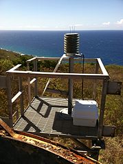 Beacon on new truss tower, 2014
 -
 View from the sea


See also
References
- ^ Rowlett, Russ. "Lighthouses of the U.S. Virgin Islands". The Lighthouse Directory. University of North Carolina at Chapel Hill. Retrieved 2016-08-22.
- ^ NOAA Nautical Chart 25644 "Frederksted Road"
- Rowlett, Russ. "Lighthouses of the U.S. Virgin Islands". The Lighthouse Directory. University of North Carolina at Chapel Hill.
- "Historic Light Station Information and Photography: West Indies / Virgin Islands". United States Coast Guard Historian's Office. Archived from the original on 2017-05-01.
External links
- Ham's Bluff Light
- Inventory of Historic Light Stations: Virgin Islands National Park Service
.svg)
| Authority control databases: Geographic |
|---|
|
| This article relating to a United States lighthouse is a stub. You can help Wikipedia by expanding it. |
|
| This United States Virgin Islands-related article is a stub. You can help Wikipedia by expanding it. |
- Lighthouses completed in 1915
- Lighthouses in insular areas of the United States
- Government buildings in the United States Virgin Islands
- 1910s establishments in the Caribbean
- 1915 establishments in Denmark
- 1915 establishments in North America
- 20th-century establishments in the Danish West Indies
- National Register of Historic Places in the United States Virgin Islands
- Lighthouses on the National Register of Historic Places
- United States lighthouse stubs
- United States Virgin Islands stubs