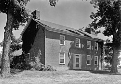
Greenwood | |
 | |
| Location | 3005 Mexico Gravel Rd., Columbia, Missouri |
|---|---|
| Coordinates | 38°58′47″N 92°17′32″W / 38.97972°N 92.29222°W |
| Area | less than one acre |
| Built | 1839 |
| Architectural style | Federal |
| NRHP reference No. | 79001347 [1] |
| Added to NRHP | January 15, 1979 |
Greenwood, also known as Greenwood Heights, is a historic home located at Columbia, Missouri. It was built about 1839, and is a two-story, "T"-plan, Federal style red brick farmhouse on a stone foundation. It is one of the oldest remaining structures in Boone County, Missouri. [2]: 4 Today the house is under private ownership. [3]
The property was added to the National Register of Historic Places in 1979. [1]
References
- ^ a b "National Register Information System". National Register of Historic Places. National Park Service. July 9, 2010.
- ^ Claire F. Blackwell (October 1978). "National Register of Historic Places Inventory Nomination Form: Greenwood" (PDF). Missouri Department of Natural Resources. Retrieved December 27, 2022.
- ^ http://www.waymarking.com/waymarks/WM3G6A "Greenwood" Columbia, Missouri Waymark
External links
- Historic American Buildings Survey (HABS) No. MO-1151, " Greenwood, Columbia vicinity, Boone County, MO"
Categories:
- Historic American Buildings Survey in Missouri
- Houses on the National Register of Historic Places in Missouri
- Federal architecture in Missouri
- Houses completed in 1839
- Houses in Columbia, Missouri
- African-American history in Columbia, Missouri
- National Register of Historic Places in Boone County, Missouri
- Central Missouri Registered Historic Place stubs


