Gilmanton, New Hampshire | |
|---|---|
Town | |
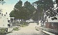
 High Street in 1910 | |
 Seal | |
 Location in
Belknap County, New Hampshire | |
| Coordinates: 43°25′26″N 71°24′49″W / 43.42389°N 71.41361°W | |
| Country | United States |
| State | New Hampshire |
| County | Belknap |
| Incorporated | 1727 |
| Villages |
|
| Government | |
| • Board of Selectmen |
|
| • Town Administrator | Heather Carpenter |
| Area | |
| • Total | 59.6 sq mi (154.4 km2) |
| • Land | 57.9 sq mi (150.0 km2) |
| • Water | 1.7 sq mi (4.4 km2) 2.87% |
| Elevation | 988 ft (301 m) |
| Population (2020)
[2] | |
| • Total | 3,945 |
| • Density | 68/sq mi (26.3/km2) |
| Time zone | UTC-5 ( Eastern) |
| • Summer ( DST) | UTC-4 ( Eastern) |
| ZIP codes | 03237 (Gilmanton) 03837 ( Gilmanton Iron Works) |
| Area code | 603 |
| FIPS code | 33-28980 |
| GNIS feature ID | 0873604 |
| Website |
www |
Gilmanton is a town in Belknap County, New Hampshire, United States. The population was 3,945 at the 2020 census. [2] Gilmanton includes the villages of Gilmanton Corners and Gilmanton Ironworks. The town became well known in the 1950s after it was rumored that the popular novel Peyton Place, written by resident Grace Metalious, was based on the town. [3]
History
Gilmanton was incorporated in 1727. First known as "Gilmantown", the town was home to the Gilman family, originally settled at Exeter. [4] Twenty-four members of the Gilman family received land grants in the new town of Gilmanton. (Other families related to the Gilmans also received grants in the new town, including the Dudleys, the Leavitts, the Folsoms and the Coffins.) [5] At one time it was the second-largest town in the state, following Portsmouth. The original town was larger than it is now, with villages and parishes including Belmont, Gunstock Parish ( Gilford), Hurricane, Tioga, Factory Village and Lakeport. A parish first called "Averytown", the site of an unprofitable iron- mining enterprise, is still known as Gilmanton Iron Works. [6]
Gilmanton Academy was incorporated in 1794 as "...one of the three academies first founded in the state...". [7] In 1808 the original building burned; the second building also burned, in 1894, and was replaced with the current building, which now houses the town offices.
Gilmanton Theological Seminary was provided for by the terms of the original charter of Gilmanton Academy. Rev. Heman Rood, from New Milford, Connecticut, was the first professor in 1835. By 1841 a large, three-story brick building designed by Ammi B. Young was completed for the seminary's use. [7]
-
 Iron Works bridge in 1910
 -
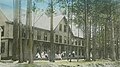 "The Pines" in 1910
 -
 Crystal Lake in 1909


Geography
According to the United States Census Bureau, the town has a total area of 59.6 square miles (154.4 km2), of which 57.9 square miles (150.0 km2) are land and 1.7 square miles (4.4 km2) are water, comprising 2.89% of the town. [1] A natural resources inventory published in 2004 noted the town's nine town forests and other dry and wetland protected areas as well as significant plant species. [8] The highest point in Gilmanton is Mount Mack, at 1,945 feet (593 m) above sea level, on the town line with Gilford. Crystal Lake is in the east, and Shellcamp Pond is in the west. Gilmanton lies fully within the Merrimack River watershed. [9]
The town is served by four state routes: 106, 129, 107 and 140. Route 107 is part of Old Province Road, an important road in New Hampshire's early history, and Route 106 is a well-traveled connection between Laconia and Concord. Route 140 is an east-west highway leading from Tilton to Alton. The intersection NH 107 and NH 140 is at Gilmanton Corners, one of the two major villages. Gilmanton Corner (or simply "Gilmanton", as shown on topographic maps) is the location of several historic buildings, including Gilmanton Academy and Centre Congregational Church. Gilmanton Ironworks is located in the eastern part of town along NH 140, near the outlet of Crystal Lake.
Adjacent municipalities
- Gilford (north)
- Alton (east)
- Barnstead (southeast)
- Loudon (south)
- Canterbury (southwest)
- Belmont (west)
Demographics
| Census | Pop. | Note | %± |
|---|---|---|---|
| 1790 | 2,613 | — | |
| 1800 | 3,752 | 43.6% | |
| 1810 | 4,338 | 15.6% | |
| 1820 | 3,752 | −13.5% | |
| 1830 | 3,816 | 1.7% | |
| 1840 | 3,485 | −8.7% | |
| 1850 | 3,282 | −5.8% | |
| 1860 | 2,373 | −27.7% | |
| 1870 | 1,642 | −30.8% | |
| 1880 | 1,485 | −9.6% | |
| 1890 | 1,211 | −18.5% | |
| 1900 | 1,100 | −9.2% | |
| 1910 | 968 | −12.0% | |
| 1920 | 814 | −15.9% | |
| 1930 | 676 | −17.0% | |
| 1940 | 708 | 4.7% | |
| 1950 | 754 | 6.5% | |
| 1960 | 736 | −2.4% | |
| 1970 | 1,010 | 37.2% | |
| 1980 | 1,941 | 92.2% | |
| 1990 | 2,609 | 34.4% | |
| 2000 | 3,060 | 17.3% | |
| 2010 | 3,777 | 23.4% | |
| 2020 | 3,945 | 4.4% | |
| U.S. Decennial Census [2] [10] | |||
Gilmanton's population was ranked #38, [11] #31, [12] and #37 in the country respectively in the 1790, 1800, and 1810 censuses.
As of the 2000 census, [13] there were 3,060 people, 1,165 households, and 900 families residing in the town. The population density was 53.6 inhabitants per square mile (20.7/km2). There were 1,848 housing units at an average density of 32.4 per square mile (12.5/km2). The racial makeup of the town was 98.59% White, 0.10% African American, 0.20% Native American, 0.13% Asian, and 0.98% from two or more races. Hispanic or Latino of any race were 0.29% of the population.
There were 1,165 households, out of which 33.1% had children under the age of 18 living with them, 68.8% were married couples living together, 5.5% had a female householder with no husband present, and 22.7% were non-families. 17.2% of all households were made up of individuals, and 5.8% had someone living alone who was 65 years of age or older. The average household size was 2.62 and the average family size was 2.96.
In the town, the population was spread out, with 24.2% under the age of 18, 5.9% from 18 to 24, 30.5% from 25 to 44, 27.6% from 45 to 64, and 11.7% who were 65 years of age or older. The median age was 40 years. For every 100 females, there were 102.9 males. For every 100 females age 18 and over, there were 100.1 males.
The median income for a household in the town was $50,542, and the median income for a family was $51,712. Males had a median income of $37,077 versus $27,727 for females. The per capita income for the town was $23,163. About 3.3% of families and 5.9% of the population were below the poverty line, including 5.8% of those under age 18 and 9.1% of those age 65 or over.
Government
In the New Hampshire Senate, Gilmanton is in the 6th district, represented by Republican James Gray. On the New Hampshire Executive Council, Gilmanton is in the 2nd district, represented by Democrat Andru Volinsky. In the United States House of Representatives, Gilmanton is in New Hampshire's 1st congressional district, represented by Democrat Chris Pappas.
Sites of interest
- Carpenter Museum of Antique Outboard Motors
- Crystal Lake
- Griswold Scout Reservation which includes Hidden Valley Scout Camp and Camp Bell, Boy Scouts of America
- Village of Gilmanton Ironworks
National Register of Historic Places
- Centre Congregational Church
- First Baptist Church of Lower Gilmanton
- Gilmanton Academy
- Smith Meeting House
Notable people

- John B. Bachelder (1825–1894), painter, photographer, historian [14]
- William Badger (1779–1852), mill owner, 15th governor of New Hampshire [15]
- Curtis Coe Bean (1828–1904), politician [16]
- Rudi Blesh (1899–1985), jazz critic and enthusiast [17]
- John C. Chase (1870–1937), shoe worker, politician [18]
- David Cote (born 1969), author, New York theater critic raised in Gilmanton [19]
- Ira Allen Eastman (1809–1881), U.S. congressman [20]
- Nehemiah Eastman (1782–1856), U.S. congressman [21]
- George G. Fogg (1813–1881), U.S. senator, diplomat; began his legal practice in Gilmanton Iron Works [22]
- John R. French (1819–1890), U.S. congressman [23]
- Charles A. Gilman (1833–1927), 9th lieutenant governor of Minnesota [24]
- H. H. Holmes (1861–1896), serial killer [25]
- Dudley Leavitt (1772–1851), author, publisher; lived in Gilmanton while founding the Gilmanton Gazette and an almanac, [26] and was a selectman [27]
- Grace Metalious (1924–1964), author of Peyton Place [28]
- Charles H. Peaslee (1804–1866), U.S. congressman [29]
- William Prescott (1788–1875), physician, politician, naturalist [30]
- Edwin David Sanborn (1808–1885), educator [31]
- John Sewell Sanborn (1819–1877), educator, judge, Canadian politician [32]
- David Sellin (1930–2006), art historian, curator of the United States Capitol
- Thorsten Sellin (1896–1994), sociologist, criminologist; died in Gilmanton [33]
- Ainsworth Rand Spofford (1825–1908), journalist, publisher; sixth Librarian of Congress [34]
- Henry M. Spofford (1821–1880), judge [35]
- Nathaniel Upham (1774–1829), politician, educator; married Judith Cogswell of Gilmanton and lived in town briefly [36]
See also
References
- ^ a b "2020 U.S. Gazetteer Files – New Hampshire". United States Census Bureau. Retrieved October 28, 2021.
- ^ a b c "Gilmanton town, Belknap County, New Hampshire: 2020 DEC Redistricting Data (PL 94-171)". U.S. Census Bureau. Retrieved October 28, 2021.
- ^ People magazine, September 28, 1981, "25 Years After Peyton Place, Her New Hampshire Town Has Not Forgiven Grace Metalious." [1]
- ^ Lancaster, Daniel (April 21, 2018). "The History of Gilmanton: Embracing the Proprietary, Civil, Literary, Ecclesiastical, Biographical, Genealogical, and Miscellaneous History, from the First Settlement to the Present Time; Including what is Now Gilford, to the Time it was Disannexed". A. Prescott. Retrieved April 21, 2018 – via Google Books.
- ^ Lancaster, Daniel (April 21, 2018). "The History of Gilmanton: Embracing the Proprietary, Civil, Literary, Ecclesiastical, Biographical, Genealogical, and Miscellaneous History, from the First Settlement to the Present Time; Including what is Now Gilford, to the Time it was Disannexed". A. Prescott. Retrieved April 21, 2018 – via Google Books.
-
^ Coolidge, Austin J.; John B. Mansfield (1859).
A History and Description of New England. Boston, Massachusetts: A.J. Coolidge. pp.
500–502.
coolidge mansfield history description new england 1859.
- ^ a b Hurd, Duane Hamilton (1885). History of Merrimack and Belknap counties, New Hampshire. Philadelphia, PA: J. W. Lewis & co. p. 785. LCCN 01007961.
- ^ "Town of Gilmanton, New Hampshire". www.gilmantonnh.org. Retrieved April 21, 2018.
- ^ Foster, Debra H.; Batorfalvy, Tatianna N.; Medalie, Laura (1995). Water Use in New Hampshire: An Activities Guide for Teachers. U.S. Department of the Interior and U.S. Geological Survey.
- ^ "Census of Population and Housing". Census.gov. Retrieved June 4, 2016.
- ^ "SCHEDULE of the whole number of PERSONS within the several Districts of the UNITED STATES, taken according to "An Act providing for the Enumeration of the Inhabitants of the United States;" passed March the 1st, 1790". U.S. Census Bureau. October 24, 1791. Retrieved October 27, 2020.
- ^ "Return of the Whole Number of Persons Within the Several Districts of the United States..." (PDF). U.S. Census Bureau. February 28, 1800. Archived (PDF) from the original on August 18, 2017. Retrieved October 27, 2020.
- ^ "U.S. Census website". United States Census Bureau. Retrieved January 31, 2008.
- ^ Metcalf, Henry Harrison; McClintock, John Norris (1915). The Granite Monthly: A New Hampshire Magazine Devoted to History ..., Volume 47. H.H. Metcalf. p. 447.
- ^ "New Hampshire Governor William Badger". National Governors Association. Retrieved December 5, 2013.
- ^ "BEAN, Curtis Coe, (1828 - 1904)". Biographical Directory of the United States Congress. Retrieved December 5, 2013.
- ^ "Jazz Scholar Rudi Blesh; Historian, Biographer, Criticpublisher=Los Angeles Times". August 31, 1985. Retrieved December 5, 2013.
- ^ Marquis, Albert Nelson. The book of Chicagoans a biographical dictionary of leading living men of the city of Chicago. Chicago: A.N. Marquis & Co., 1911. 132. Print. Copy & Paste | Parenthetical.
- ^ "David Cote". histriomastix.typepad.com. Retrieved April 21, 2018.
- ^ "EASTMAN, Ira Allen, (1809 - 1881)". Biographical Directory of the United States Congress. Retrieved December 5, 2013.
- ^ "EASTMAN, Nehemiah, (1782 - 1856)". Biographical Directory of the United States Congress. Retrieved December 5, 2013.
- ^ "FOGG, George Gilman - Biographical Information". bioguide.congress.gov. Retrieved April 21, 2018.
- ^ "FRENCH, John Robert, (1819 - 1890)". Biographical Directory of the United States Congress. Retrieved December 5, 2013.
- ^ "Charles Andrew Gilman". Minnesota Historical Society. Retrieved December 5, 2013.
- ^ "H. H. Holmes". A+E Television Networks, LLC. Retrieved December 5, 2013.
- ^ Cornelius, Elias. The American quarterly register Vol. 13, Boston 1841. 176. Print.
- ^ Lancaster, Daniel. The history of Gilmanton, embracing the proprietary, civil, literary, ecclesiastical, biographical, genealogical, and miscellaneous history, from the first settlement to the present time; including what is now Gilford, to the time it was disannexed. Gilmanton N.H.: Printed by A. Prescott, 1845. 140, 142. Print.
- ^ Toth, Emily. Inside Peyton Place. Garden City, NY: Doubleday, 1981. Print.
- ^ "PEASLEE, Charles Hazen, (1804 - 1866)". Biographical Directory of the United States Congress. Retrieved December 5, 2013.
- ^ Wilson, James Grant, and John Fiske. Appleton's cyclopædia of American biography,. New York: D. Appleton and Co., 1900. Print.
- ^ The Granite Monthly: A New Hampshire Magazine, Volume 16. Granite Monthly Co. 1894. p. 131.
- ^ "SANBORN, JOHN SEWELL". University of Toronto. Retrieved December 5, 2013.
- ^ Charlesworth, James C. (1969) "The Academy Dips Its Colors to Dr. Sellin," Annals of the American Academy of Political and Social Science 381: pp. iii–iv.
- ^ Johnson, Rossiter; Brown, John Howard (1904). The Twentieth Century Biographical Dictionary of Notable Americans. Biographical Society.
- ^ Hardy, Stella Pickett (1911). Colonial Families of the Southern States of America: A History and Genealogy of Colonial Families who Settled in the Colonies Prior to the Revolution. T.A. Wright. p. 368.
- ^ "Home". www.andoverhistorical.org. Archived from the original on December 10, 2013. Retrieved April 21, 2018.
External links
- Official website
- Gilmanton Year-Round Library ("Barn Library")
- Gilmanton Corner Library
- Gilmanton Historical Society Archived 2010-08-13 at the Wayback Machine
- Gilmanton Snowmobile Association
- New Hampshire Economic and Labor Market Information Bureau Profile
Places adjacent to Gilmanton, New Hampshire | ||||||||||||||||
|---|---|---|---|---|---|---|---|---|---|---|---|---|---|---|---|---|
| ||||||||||||||||
Municipalities and communities of
Belknap County, New Hampshire, United States | ||
|---|---|---|
| City |  | |
| Towns | ||
| CDPs | ||
| Other villages | ||
| Footnotes | ‡This populated place also has portions in an adjacent county or counties | |
| International | |
|---|---|
| National | |