-
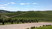
 Luiz Argenta Winery, the largest winery in the City
 -
 Luiz Argenta
 -
 Luiz Argenta
 -
 Luiz Argenta
 -
 Luiz Argenta
 -
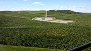 Luiz Argenta
 -
 Luiz Argenta
 -
 Luiz Argenta
 -
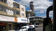 Flores da Cunha Downtown
 -
 A church at Flores da Cunha Town
This article needs additional citations for
verification. (October 2014) |
Flores da Cunha | |
|---|---|
 | |
 Flag  Seal | |
| Nickname: Terra do Galo (The land of the Rooster) | |
 Flores da Cunha Location in Brazil | |
| Coordinates: 29°01′50″S 51°11′00″W / 29.03056°S 51.18333°W | |
| Country | Brazil |
| Region | South |
| State | State of Rio Grande do Sul |
| Founded | May 17, 1924 |
| Government | |
| • Mayor | Lidio Scortegagna (PMDB) |
| Area | |
| • Total | 272,662 km2 (105,275 sq mi) |
| Elevation | 756 m (2,480 ft) |
| Population (2020
[1]) | |
| • Total | 31,063 |
| • Density | 99.2/km2 (257/sq mi) |
| Time zone | UTC−3 ( BRT) |
| Website | Flores da Cunha City Hall |

Flores da Cunha is a municipality in the state of Rio Grande do Sul, Brazil. It is the largest producer of wines inside Brazil. The Venetian language in its Brazilian form Talian is co-official with Portuguese in Flores da Cunha.
History
The Serra Gaúcha, where the municipality is located, was inhabited by caingangue indigenous people since time immemorial. The territory that makes up the current municipality of Flores da Cunha began to be occupied by immigrants, especially from Northern Italy, starting in 1876.
Between 1876 and 1877, some immigrant families settled in the current territory of the municipality. Among them, we can highlight the Soldatelli, Borghetti, Mambrini, Letti, Piardi, Grizza, Dall Conte, Carletti, Rossetto, Curra, Oldra, and others. The largest wave of Italian colonizers, however, settled between 1878 and 1892, the time when the primitive village of São Pedro was founded, and later, also São José. Only in the late 1880s were the two villages reunified, forming the village of Nova Trento. [2] [3] On December 12, 1882, the first chaplain of the locality, Fr. Luigi Centin, was appointed. [4]
In 1890, when the old Colônia Caxias was elevated to the status of a municipality, to which Nova Trento belonged, the village became the seat of the 2nd District. However, documents state that shortly thereafter, still in the early years of the 20th century, a committee formed by local community leaders, dissatisfied with the little attention received from the mother municipality, fought insistently for the district's emancipation. The conquest was only achieved on May 17, 1924. The new municipality, installed the following week, on May 24, included the territories belonging to Nova Pádua, until then the 4th District of Caxias and emancipated from Flores da Cunha in 1992, Otávio Rocha, and Mato Perso, the current 3rd and 4th Districts of Flores da Cunha. [2]
District created under the name Nova Trento, by Act No. 5, of 07-03-1890, and by Municipal Act No. 1, of 05-26-1924, subordinated to the municipality of Caxias (now Caxias do Sul). [3]
Elevated to the category of municipality under the name Nova Trento, by Municipal Decree No. 3,320, of 05-17-1924. By Decree No. 12, of 12-21-1935, it was renamed Flores da Cunha. [5]
The municipality consists of three districts: Flores da Cunha, Mato Perso, and Otávio Rocha.
In 2015, the Talian language was co-officialized in Flores da Cunha. [6] [7] [8]
Climate
Because of the Altitude of 756 meters above the sea level, The Climate of Flores da Cunha is Oceanic Climate type Cfb. With warm (not hot) to cool summers with some few experiences of snowfall between July and August.
| Flores da Cunha | ||||||||||||||||||||||||||||||||||||||||||||||||||||||||||||
|---|---|---|---|---|---|---|---|---|---|---|---|---|---|---|---|---|---|---|---|---|---|---|---|---|---|---|---|---|---|---|---|---|---|---|---|---|---|---|---|---|---|---|---|---|---|---|---|---|---|---|---|---|---|---|---|---|---|---|---|---|
| Climate chart ( explanation) | ||||||||||||||||||||||||||||||||||||||||||||||||||||||||||||
| ||||||||||||||||||||||||||||||||||||||||||||||||||||||||||||
| ||||||||||||||||||||||||||||||||||||||||||||||||||||||||||||
Gallery


See also
References
- ^ IBGE 2020
- ^ a b "Municipality of Flores da Cunha - City - History". www.floresdacunha.rs.gov.br. Retrieved 2022-06-01.
- ^ a b "Flores da Cunha histórico". cidades.ibge.gov.br. Retrieved 2022-06-01.
- ^ COSTA, Rovílio (1997). Pioneers of the Colonies of Alfredo Chaves, Encantado e Guaporé. Porto Alegre: EST Edições. p. 116.
- ^ "historico de Flores da Cunha". cidades.ibge.gov.br. Retrieved 2022-06-01.
- ^ Talian é língua cooficial de Flores da Cunha
- ^ Embaixatrizes da FenaVindima participaram de aula de Talian, Revista News, accessed on October 21, 2019
- ^ Lei municipal Nº 3.180, de 27 de abril de 2015 - Dispõe sobre a cooficialização da língua Talian, à língua portuguesa, no município de Flores da Cunha

| International | |
|---|---|
| National | |
 | This geographical article relating to Rio Grande do Sul is a stub. You can help Wikipedia by expanding it. |