
All types of floods can occur in California, though 90 percent of them are caused by river flooding in lowland areas. [1] [2] Such flooding generally occurs as a result of excessive rainfall, excessive snowmelt, excessive runoff, levee failure, poor planning or built infrastructure, or a combination of these factors. Below is a list of flood events that were of significant impact to California.
A 2022 study found that Climate change in California, is likely to increase the extremity of water cycle events such as droughts and megafloods, greatly increasing the severity of future floods due to atmospheric rivers. [2] In part this is due to the expectation that the Sierra Nevada mountains, which typically retain water as snow, will no longer be as cold. [2]
Early historic record
Geologic evidence indicates that "megafloods" occurred in the California region in the following years A.D.: 212, 440, 603, 1029, c. 1300, 1418, 1605, and 1750. [3] [4] Prior to European settlement, these early floods predominantly affected the indigenous peoples of California.
California flood of 1605
In 1605, present-day California was subject to massive flooding due to an unusually powerful atmospheric river. This was potentially the largest flooding event of the prior 2,000 years. [3] [5]
1800–1899
Los Angeles flood of 1825
This flood changed the course of the Los Angeles River from its western outlet into Santa Monica Bay following the course of Ballona Creek to a southern outlet at San Pedro Bay near where it is today. [6]
January 1850
In January 1850, a major flood devastated the then new city of Sacramento; rain from heavy storms saturated the ground upon which Sacramento was built, and the American and Sacramento rivers crested simultaneously. [7]
Years closely following January 1850
Many subsequent floods occurred following 1850 in Sacramento and other low-lying cities along the Sierra-originating rivers, caused by hydraulic mining in the foothills. Malakoff Diggins was one example, in which silt runoff purportedly raised the river beds in the valley below by an additional two feet. Hydraulic gold mining, widespread at the time, would eventually be eliminated by the California Legislature.[ citation needed]
October 1858: Schooner-beaching storm surge in San Diego
December 1861 – January 1862: California's Great Flood
Beginning on December 24, 1861, and lasting for 45 days, the largest flood in California's recorded history occurred, reaching full flood stage in different areas between January 9–12, 1862. The entire Sacramento and San Joaquin valleys were inundated for 300 miles (480 km), averaging 20 miles (32 km) in breadth. State government was forced to relocate from the capital in Sacramento for 18 months to San Francisco. The rain created an inland sea in Orange County, lasting about three weeks with water standing 4 feet (1.2 m) deep up to 4 miles (6 km) from the river. [1]
The Los Angeles basin was flooded from the San Gabriel Mountains to the Palos Verdes Peninsula, at variable depths, excluding the higher lands which became islands until the waters receded. The Los Angeles basin lost 200,000 cattle by way of drowning, as well as homes, ranches, farm crops and vineyards being swept-away.
1900–1949
1909: California flood
The storm extended from Fort Ross along the Sacramento River up to the Feather River basin. One small town along the flood path ( La Porte) was inundated with 57.41 inches (1,458 mm) over the course of 20 days. The flood episodes of 1907 and 1909 in California resulted in an overhaul of planned statewide flood control designs. [1]
March 1928: St. Francis Dam disaster

A recently constructed dam collapsed 40 miles northwest of downtown Los Angeles. The flooding beneath the dam killed at least 431 people, and probably more. [8] [9] [10]
December 1933 – January 1934: Crescenta Valley flood
In the last week of December 1933, 12 inches (300 mm) of rain fell in the communities of La Crescenta, La Cañada and Montrose just north of Los Angeles. On New Year's Eve, more rain fell. The result was a flood of mud and water that began around midnight, destroying more than 400 homes in this area. This was commemorated in Woody Guthrie's song "Los Angeles New Year's Flood". As a result of this flood, the Army Corps of Engineers and the County of Los Angeles built a flood control system of catch basins and concrete storm drains to prevent a repeat of the disaster.
February 1937: Santa Ana flood
The storm of February 4–7, 1937 resulted in the highest four-day rainfall totals at several stations in the Santa Ana River basin. The Riverside North station had over 8 inches (200 mm) of rain in that four days, which equaled a 450-year event. Other stations also received high amounts of rain within those four days. [1]
December 1937: Northeast California flood
The storm of December 1937 was a high-elevation event in the northeast corner of the state. [1]
February–March 1938: Los Angeles Flood of 1938
.jpg)
The Los Angeles flood of 1938 was one of the largest floods in the history of Los Angeles, Orange, and Riverside Counties in southern California. The flood was caused by two Pacific storms that swept across the Los Angeles Basin in February-March 1938 and generated almost one year's worth of precipitation in just a few days. Between 113–115 people were killed by the flooding. [11] The Los Angeles, San Gabriel, and Santa Ana Rivers burst their banks, inundating much of the coastal plain, the San Fernando and San Gabriel Valleys, and the Inland Empire. Flood control structures spared parts of Los Angeles County from destruction, while Orange and Riverside Counties experienced more damage. [11]
The flood of 1938 is considered a 50-year flood. [12] It caused $78 million of damage ($ in 2023 dollars), [12] making it one of the costliest natural disasters in Los Angeles' history. [13] In response to the floods, the U.S. Army Corps of Engineers and other agencies began to channelize local streams in concrete, and built many new flood control dams and debris basins. These works have been instrumental in protecting Southern California from subsequent flooding events, such as in 1969 and 2005, which both had a larger volume than the 1938 flood. [13]September 1939: Los Angeles River

1950 – 1999
November 1950: California flood
A statewide disaster was declared November 21 when floods caused 9 deaths and $32 million in damage. [17]
December 1955: California flood
The storm affected the central Sierra Nevada mountains and South Bay areas. The Eel River on the North Coast saw the greatest flow of record to that time while Central Valley rivers saw near-record flows. A statewide disaster was declared, with the storm resulting in 74 deaths and $200 million in economic losses. The heaviest 24-hour rainfall was recorded on December 20, when 15.34 inches (390 mm) fell in Shasta County. [1] The storm's toll on Sutter County was severe. At 12:04 a.m. on December 24, 1955, a levee on the west bank of the Feather River, at Shanghai Bend, collapsed and a wall of water 21 feet high entered the county, flooding 90 percent of Yuba City and the farmlands in the southern Yuba City basin. Some 600 people were rescued by helicopter and 37 people drowned. [18]
October 1962: Columbus Day Flood
The storm caused widespread damage in the Pacific Northwest and British Columbia.
March 1964: North Coast California tsunami
The 1964 Alaska earthquake caused a tsunami in March, devastating several North Coast towns and resulting in 14 deaths and an economic loss of $14 million in Del Norte County alone. [1]
December 1964: California flood
The six days from December 19–24, 1964 were the wettest ever recorded at many stations on the North Coast. Every major stream in the North Coast produced new high values of extreme peak flows. 34 California counties were declared disaster areas. [1]
September 1976: Hurricane Kathleen (Ocotillo flash flood)
Hurricane Kathleen was a tropical cyclone that had a destructive impact in California. On September 7, 1976, a tropical depression formed; two days later it accelerated north towards the Baja California Peninsula. Kathleen brushed the Pacific coast of the peninsula as a hurricane on September 9 and made landfall as a fast-moving tropical storm the next day. With its circulation intact and still a tropical storm, Kathleen headed north into the United States and affected California and Arizona. Kathleen finally dissipated late on September 11.
Damage in the United States was considerable. California received record rainfall, with over a foot of rain falling in some areas. Flooding caused catastrophic destruction to Ocotillo, and six people drowned. [19] Flooding extended west; railway tracks were destroyed in Palm Desert and high winds and severe flooding were recorded in Arizona. Overall, the damage total was $160 million (1976 USD) and 12 deaths were attributed to the storm.
August 1977: Hurricane Doreen
Hurricane Doreen and its remnants caused severe flooding in northwestern Mexico and the southwestern United States. In Mexico, heavy rainfall was reported on Baja California and the mainland of Mexico. Flooding left 2,000 people homeless in Mexicali along the United States-Mexico border, in addition, 325 homes and businesses were destroyed in southern California. Several highways were also flooded during the passage of the storm, most notably, lanes on Interstate 8 and Interstate 15 were washed out. In San Diego and Imperial County, the total damage to agricultural interests was $25 million (1977 USD). In addition, eight fatalities were reported in California. Elsewhere, impact from Doreen was relatively light.
January 1982: Northern California flood
Heavy rainfall in the San Francisco Bay region on January 3–5 triggered thousands of debris flows from Santa Cruz Country to Contra Costa and Sonoma Counties, as well as flooding along the San Lorenzo River, Soquel Creek, and Aptos Creek in Santa Cruz County. Floods along creeks in Marin County added significant amounts of sediment to Tomales Bay. The landslides caused at least $66 million in damage. Landslides caused 25 of the 33 storm-caused deaths. Total estimated storm-related losses were $280 million. [20]
1986 California and Western Nevada floods
On February 11, 1986, a vigorous low pressure system drifted east out of the Pacific, creating a Pineapple Express [21] that lasted through February 24 unleashing unprecedented amounts of rain on northern California and western Nevada. [22] The nine-day storm over California constituted half of the average annual rainfall for the year. [1] Record flooding occurred in three streams that drain to the southern part of the San Francisco Bay area. [22] Extensive flooding occurred in the Napa and Russian rivers. Napa, north of San Francisco, recorded their worst flood to this time [23] while nearby Calistoga recorded 29 inches (740 mm) of rain in 10 days, creating a once-in-a-thousand-year rainfall event. [21] Records for 24-hour rain events were reported in the Central Valley and in the Sierra. Thousand-year rainfalls were recorded in the Sierras. [1] The heaviest 24-hour rainfall ever recorded in the Central Valley at 17.60 inches (447 mm) occurred on February 17 at Four Trees in the Feather River basin. [21] In Sacramento, nearly 10 inches (250 mm) of rain fell in an 11-day period. [1] System breaks in the Sacramento River basin included disastrous levee breaks in the Olivehurst and Linda area on the Feather River. [1] Linda, about 40 miles (64 km) north of Sacramento, was devastated after the levee broke on the Yuba River's south fork, forcing thousands of residents to evacuate. [24] In the San Joaquin River basin and the Delta, levee breaks along the Mokelumne River caused flooding in the community of Thornton and the inundation of four Delta islands. [1] Lake Tahoe rose 6 inches (150 mm) as a result of high inflow. [22]
The California flood resulted in 13 deaths, 50,000 people evacuated and over $400 million in property damage. [1] 3000 residents of Linda joined in a class action lawsuit Paterno v. State of California, which eventually reached the California Supreme Court in 2004. The California high court affirmed the District Court of Appeal's decision that said California was liable for millions of dollars in damages. [24]
January and March 1995: California flood
During the events of January and March 1995, over 100 stations recorded their greatest 1-day rainfalls in that station's history. The major brunt of the January storms hit the Sacramento River Basin and resulted in small stream flooding primarily due to storm drainage system failures, though flooding affected nearly every part of the state. The Salinas River exceeded its previous measured record crest by more than four feet, which was within a foot or two of the reputed crest of the legendary 1862 flood. The Napa River set a new peak record, and the Russian and Pajaro rivers approached their record peaks. 28 people were killed and the flood cost $1.8 billion. [1]
The flooding also affected Southern California. [25]
January 1997: Merced River flood
A series of extratropical storms, powered by the subtropical jet stream and the pineapple express, struck northern California from late December 1996 to early January 1997. [1] December 1996 was one of the wettest Decembers on record. [1] The Klamath River on California's North Coast experienced significant flooding which led to the river permanently changing course in some areas. [26] The Klamath National Forest experienced its worst flood since 1974. [26] Unprecedented flows from rain surged into the Feather River basin while melted snow surged into the San Joaquin River basin. [26] Rain fell at elevations up to 11,000 feet (3,400 m), prompting snow melt. [1] [26] The Cosumnes River, a tributary to the San Joaquin River, bore the brunt of the flooding. [26] Sacramento was spared, though levee failures flooded Olivehurst, Arboga, Wilton, Manteca, and Modesto. [27] Massive landslides in the Eldorado National Forest east of Sacramento closed U.S. Route 50. [26] Damages totaled US$35 million (1997 dollars). [26]
Watersheds in the Sierra Nevada were already saturated by the time three subtropical storms added more than 30 inches (760 mm) of rain in late December 1996 and early January 1997. [1] Levee failures due to breaks or overtopping in the Sacramento River Basin resulted in extensive damages. [1] In the San Joaquin River Basin, dozens of levees failed throughout the river system and produced widespread flooding. [1] The Sacramento-San Joaquin River Delta also experienced several levee breaks and levee overtopping. [1] 48 counties were declared disaster areas, including all 46 counties in northern California. [1] Over 23,000 homes and businesses, agricultural lands, bridges, roads and flood management infrastructures – valued at about $2 billion – were damaged. Nine people were killed and 120,000 people were evacuated from their homes. [1] 300 square miles (780 km2) were flooded, including the Yosemite Valley, which flooded for the first time since 1861–1862. [1]
February 1998: Palo Alto Flood
The storm caused damage in urbanized areas of East Palo Alto and the surrounding cities in the flood plain of the San Francisquito Creek.[ citation needed]
2000–present
California experienced significant flooding events due to oceanic activity in 2005, 2014, 2017, 2022, and 2023.
Los Angeles County flood of 2005
The Los Angeles County flood of 2005 was the first large flood in Los Angeles County since 1938. It affected communities near the Los Angeles River and areas ranging from Santa Barbara County in the north to Orange and San Diego Counties in the south, as well as Riverside and San Bernardino Counties to the east. Large amounts of rain in January caused the Los Angeles River basin to overflow. The Ventura, Santa Ynez, and Santa Clara Rivers also flooded. [28]
August 2014: Coastal flooding due to "Big Wednesday" wave action
Owing to the size of Marie, increased surf was anticipated well north of the hurricane. High surf advisories were issued in California for the Greater Los Angeles Area. Forecasters at the local National Weather Service office warned residents in Los Angeles and Ventura counties could "potentially see the largest surf in recent years generated by a hurricane." [29] Swells of 10 to 15 ft (3.0 to 4.6 m) were anticipated with the risk of coastal flooding and structural damage. Advisories were also issued for Orange and Santa Barbara counties. [29] [30] Surf in the region ultimately reached 20 ft (6.1 m) along south-facing shores while west-facing beaches only saw waves up to 8 ft (2.4 m). [31]


2017 California floods
Flooding in 2017 affected parts of California in the first half of the year. Northern California saw its wettest winter in almost a century, breaking the record set in 1982–83. [32] The same storm systems also flooded parts of western Nevada and southern Oregon. The damage was estimated at $1.55 billion ($ today [33]), [34] including damage to California roads and highways estimated at more than $1.05 billion. [35] [36]
The flooding occurred at the end of one of California's worst droughts on record, and much of the state was unprepared to handle the huge volume of rain and snow. The precipitation helped to refill surface water supplies, including many major lakes and reservoirs, but had limited impact on groundwater reserves. [37] Governor Jerry Brown declared the drought officially over on April 4, 2017. [38]January 2017: Russian River flooding
The Russian River near Sacramento, California rose three feet above flood stage, overspreading about 500 houses with water. Dams were opened to relieve pressure from built-up floodwaters, with the Sacramento Weir being opened for the first time in eleven years. [39] Numerous areas in Northern California closed roads to flood and mudslide conditions, with U.S. Route 395 temporarily closed in both directions. [40] Over 570,000 customers of the Pacific Gas and Electric Company lost power in Northern and Central California during the event. Over 3,000 people in the Guerneville area were evacuated. [41]
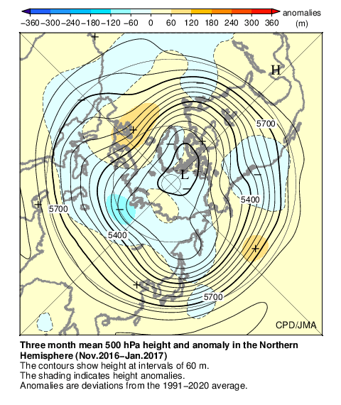
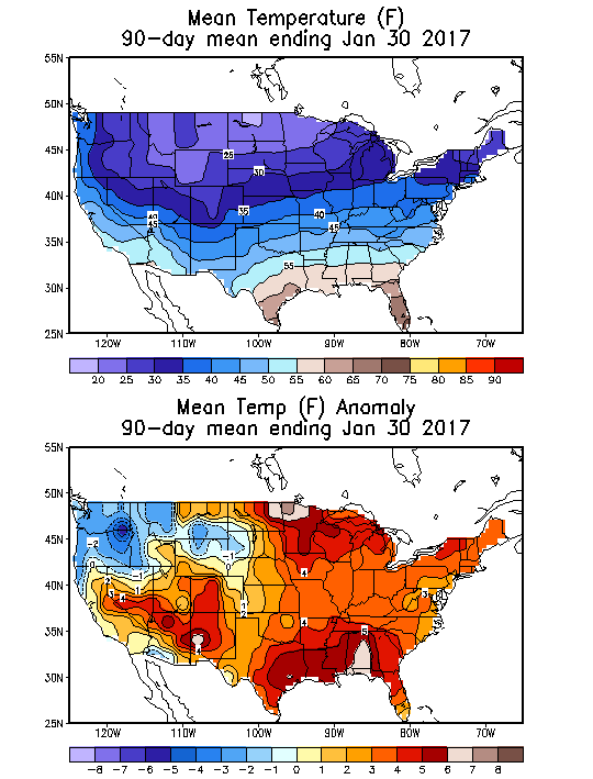
The high-amplitude ridge off the West Coast that characterized the preceding drought was replaced by a persistent presence of anomalous troughs impacting California. Another feature in the 2013–2015 winters was the extreme temperature contrast between a warm western U.S. and a cold eastern continent. These anomalous temperature and circulation patterns were referred to as the North American winter “dipole”. [42] [43] [44] Figure (a) shows the climatological geopotential height (Z) overlaid with its eddy component, in which the dipole centers are located (indicated by X and +). The dipole basically describes the wintertime stationary waves over North America, which contribute to the mean temperature difference between the climatologically warmer western U.S. and colder eastern half. Therefore, an amplification of the stationary wave would enhance such a temperature difference, like in 2013–2015 winters, while a weakening of the stationary wave would reverse the situation, like in 2016–2017 winter. [45] Indeed, in winter 2016–2017 this dipole was apparently reversed. [46] [47]
February 2017: Oroville Dam spillway failures

This article needs to be updated. (March 2019) |
In February 2017, heavy rainfall damaged Oroville Dam's main and emergency spillways, prompting the evacuation of more than 180,000 people living downstream along the Feather River and the relocation of a fish hatchery.
Heavy rainfall during the 2017 California floods damaged the main spillway on February 7, so the California Department of Water Resources stopped the spillway flow to assess the damage and contemplate its next steps. The rain eventually raised the lake level until it flowed over the emergency spillway, even after the damaged main spillway was reopened. As water flowed over the emergency spillway, headward erosion threatened to undermine and collapse the concrete weir, which could have sent a 30-foot (10 m) wall of water into the Feather River below and flooded communities downstream. No collapse occurred, but the water further damaged the main spillway and eroded the bare slope of the emergency spillway.2022–2023 California floods
.jpg)
This article is missing information about any rainfall and flooding events in February and early March. (April 2023) |
Periods of heavy rainfall caused by multiple atmospheric rivers in California between December 31, 2022, and March 25, 2023, resulted in floods that affected parts of Southern California, the California Central Coast, Northern California and Nevada. [48] [49] The flooding resulted in property damage [50] [51] [52] and at least 22 fatalities. [53] At least 200,000 homes and businesses lost power during the December-January storms [54] and 6,000 individuals were ordered to evacuate. [55]
The floods were widely reported by media as an example of how climate change is increasing extreme changes in weather, especially cycles of precipitation and drought. [56] [57] Scientists interviewed by Los Angeles Times said that further study is needed to determine the connection and California has recorded similar events almost every decade since records started in the 19th century. [58] Other scientists have emphasized that floods were caused by ocean warming, directly related to climate change. [59] Scientist Kevin Trenberth declared that "the interaction between the warming ocean and the overlying atmosphere (...) is producing these prodigious rainfalls that have occurred in so many places around the world recently". [60] Climate change is intensifying the water cycle. This brings more intense rainfall and associated flooding, as well as more intense drought in many regions. It has been both predicted by scientists and observed in the last years and documented by the IPCC (International Panel for Climate Change 6th assessment report). [61] Before the rains started, California had been in an extreme drought. [62]
Due to the storms, Governor Gavin Newsom declared a state of emergency on January 4, 2023. [63] President Joe Biden then declared a state of emergency in 17 California counties on January 9, 2023. [64] That same day, two lawmakers sent a letter urging President Biden to declare a state of emergency for San Luis Obispo County and Santa Barbara County. [65] Biden approved a major disaster declaration for Santa Cruz, Sacramento and Merced counties on January 14. Monterey, San Luis Obispo and Santa Barbara counties were added a few days later to the declaration. [66] Later, Ventura County was approved disaster relief. [67] Biden surveyed the damage with Newsom on January 19. [68]2024 California floods
Starting on February 4, 2024, California, particularly the Los Angeles area, experienced extreme flooding and mudslides from an atmospheric river. So the Los Angeles got received 4.10" inches of rain, since the March 15, 2003, from record rainfall. [69] Meteorologist Dr. Reed Timmer stated that " Biblical flooding" was possible during the atmospheric river. [70]
See also
- El Niño–Southern Oscillation
- Floods in the United States before 1900
- Floods in the United States (1900–1999)
- Floods in the United States (2000–present)
- ARkStorm
References
- ^ a b c d e f g h i j k l m n o p q r s t u v w x y "Historic Rainstorms in California". California Department of Water Resources. Archived from the original on 2007-08-24. Retrieved 2007-10-23.
- ^ a b c Huang, Xingying; Swain, Daniel L. (2022-08-12). "Climate change is increasing the risk of a California megaflood". Science Advances. 8 (32): eabq0995. Bibcode: 2022SciA....8..995H. doi: 10.1126/sciadv.abq0995. ISSN 2375-2548. PMC 9374343. PMID 35960799.
- ^ a b Overview of the Arkstorm Scenario (PDF). United States Geological Survey. p. 2.
- ^ Dettinger, M. D.; Ingram, B. L. (January 2013). "The Coming Megafloods" (PDF). American Scientific. 169: 64–71.
- ^ "ARkStorm: California's other "Big One"". United States Geological Survey.
- ^ Deverell, William F. (June 3, 2004). Whitewashed Adobe: The Rise of Los Angeles and the Remaking of Its Mexican Past. University of California Press. ISBN 9780520932531 – via Google Books.
- ^ Severson, Thor (July 26, 1973). Sacramento: an illustrated history: 1839 to 1874, from Sutter's Fort to Capital City. California Historical Society – via Internet Archive.
- ^ Stansell, Ann (August 2014). Memorialization and Memory of Southern California's St. Francis Dam Disaster of 1928. California State University, Northridge (Thesis).
- ^ Stansell, Ann C. (February 2014). "Roster of St. Francis Dam Disaster Victims". Santa Clarita Valley History In Pictures.
- ^ Doughty, Caitlin. "The Massive LA Disaster You've Never Heard Of". Ask A Mortician (YouTube). Archived from the original on 2021-12-12. Retrieved 2020-11-12.
- ^ a b "Los Angeles Basin's 1938 Catastrophic Flood Event". Archived from the original on May 9, 2009. Retrieved 2009-05-12.
- ^ a b Romo, Rene (1988-02-22). "Flood of Memories : Longtime Valley Residents Recall 1938 Deluge That Took 87 Lives, Did $78 Million in Damage". Los Angeles Times. Retrieved 2017-08-17.
- ^ a b "The History of the Los Angeles River". L.A. River Connection. Archived from the original on 2007-06-11.
- ^ a b "A History of Significant Local Weather Events" (PDF). National Weather Service Forecast Office San Diego, California. p. 10. Archived from the original (PDF) on 2008-02-29. Retrieved 2007-02-02.
- ^ Michael Chenowyth; Chris Landsea. "The San Diego Hurricane of October 2, 1858" (PDF). Bulletin of the American Meteorological Society. pp. 1698–97. Archived (PDF) from the original on 9 April 2008. Retrieved 2008-03-08.
- ^ Oberholtz, Chris (August 21, 2023). "When was the last time a hurricane or tropical storm hit California?". Fox Weather. Retrieved August 21, 2023.
- ^ "Yolo County Disasters Since 1950". Yolo Operational Area Multi-Hazard Mitigation Plan. Archived from the original on 18 July 2011. Retrieved 29 March 2011.
- ^ County of Sutter, Office of Emergency Management
- ^ Duginski, Paul (August 22, 2019). "Could a hurricane lash Los Angeles? 80 years ago, this deadly storm came close". Los Angeles Times. Retrieved August 28, 2019.
- ^ Ellen, Stephen D.; Wieczorek, Gerald F. (1988). "Landslides, floods, and marine effects of the storm of January 3–5, 1982, in the San Francisco Bay Region, California" (PDF). U.S. Geological Survey Professional Paper (1434). Retrieved 3 March 2012.
- ^ a b c "1986 Flood Disaster". Archived from the original on 2007-10-21. Retrieved 2007-10-22.
- ^ a b c "Summary of Significant Floods in the United States, 1986". U.S. Geological Survey (USGS), Kansas Water Science Center. Archived from the original on 2006-09-25. Retrieved 2007-10-22.
- ^ Napa River flood of 1986
- ^ a b "1986 Flood Victims To Get Millions". KCRA 3. Archived from the original on 2008-10-26. Retrieved 2007-10-22.
- ^ Storm & Flooding, Los Angeles Jan. 1995 – TV News Coverage, retrieved 2023-09-01
- ^ a b c d e f g "Aftermath of the 1997 Flood: Summary of a Workshop". Archived from the original on October 8, 2007.
- ^ "Sacramento Flood Risk". Sacramento Area Flood Control Agency (SAFCA). Archived from the original on 2005-04-26. Retrieved 2007-10-22.
- ^ Barber, Megan (2017-01-06). "4 historic California storms that caused serious destruction". Curbed SF. Retrieved 2017-09-01.
- ^ a b "Severe Weather Statement: High Surf Advisory". National Weather Service in Los Angeles, California. Iowa Environmental Mesonet National Weather Service. August 24, 2014. Retrieved September 6, 2014.
- ^ "Severe Weather Statement: High Surf Advisory". National Weather Service in San Diego, California. Iowa Environmental Mesonet National Weather Service. August 25, 2014. Retrieved August 25, 2014.
- ^ Sandy Mazza (August 28, 2014). "Catalina Island digging out from Hurricane Marie winds, swells". Daily Breeze. Retrieved August 31, 2014.
- ^ Parvini, Sarah (2017-04-13). "Northern California gets its wettest winter in nearly a century". Los Angeles Times. Retrieved 2017-06-10.
- ^ 1634–1699: McCusker, J. J. (1997). How Much Is That in Real Money? A Historical Price Index for Use as a Deflator of Money Values in the Economy of the United States: Addenda et Corrigenda (PDF). American Antiquarian Society. 1700–1799: McCusker, J. J. (1992). How Much Is That in Real Money? A Historical Price Index for Use as a Deflator of Money Values in the Economy of the United States (PDF). American Antiquarian Society. 1800–present: Federal Reserve Bank of Minneapolis. "Consumer Price Index (estimate) 1800–". Retrieved February 29, 2024.
- ^ Doyle Rice; Jim Sergent; George Petras; Janet Loehrke (October 18, 2017). "2017 could tie record for billion-dollar disasters in a year. Here's why". USA Today Weather. Retrieved November 7, 2017.
- ^ Wamsley, Laurel (2017-05-25). "'Mother Of All Landslides' In Big Sur Buries Section Of California's Highway 1". National Public Radio. Retrieved 2017-06-10.
- ^ "California's Big Sur's $54 Million 'Catastrophic Landslide' a Result of Drought Followed by Deluge, Scientists Say". The Weather Company. February 19, 2019. Retrieved February 20, 2019.
- ^ Miller, Craig (2017-06-13). "4 Things You Should Know About California's Biggest Reservoir". KQED. Retrieved 2017-06-13.
- ^ "California's drought is officially over, Gov. Jerry Brown says". CBS News. Associated Press. 2017-04-07. Retrieved 2017-04-16.
- ^ Adamczyk, Ed (January 10, 2017). "Three dead in California; Russian River floods 500 homes". United Press International. Retrieved January 10, 2017.
- ^ ""Atmospheric river" from Hawaii pounding Northern California, threatening Nevada". CBS News. January 9, 2017. Retrieved January 10, 2017.
- ^ Dobuzinskis, Alex (January 9, 2017). "Thousands in California and Nevada told to evacuate due to flooding". Reuters.com. Retrieved January 10, 2017.
- ^ Wang, S.-Y.; Hipps, L.; Gillies, R. R.; Yoon, J.-H. (2014). "Probable causes of the abnormal ridge accompanying the 2013–2014 California drought: ENSO precursor and anthropogenic warming footprint". Geophysical Research Letters. 41 (9): 3220–3226. Bibcode: 2014GeoRL..41.3220W. doi: 10.1002/2014GL059748.
- ^ Singh, D.; et al. (2016). "Recent amplification of the North American winter temperature dipole". Journal of Geophysical Research: Atmospheres. 121 (17): 9911–9928. Bibcode: 2016JGRD..121.9911S. doi: 10.1002/2016jd025116. PMC 5095811. PMID 27840780.
- ^ Wang, S.-Y.; Huang, W.-R.; Yoon, J.-H. (2015). "The North American winter 'dipole' and extremes activity: A CMIP5 assessment". Atmospheric Science Letters. 16 (3): 338–345. Bibcode: 2015AtScL..16..338W. doi: 10.1002/asl2.565. S2CID 129026558.
- ^ "Usu climate lab – CA Drought & Dipole". Archived from the original on 2017-02-23. Retrieved 2017-02-22.
- ^ "Three month mean : image" (GIF). Data.jma.go.jp. Retrieved 26 July 2019.
- ^ "Three month temperature : image" (GIF). Cpc.ncep.noaa.gov. Retrieved 26 July 2019.
- ^ "Heavy rain and snow falls across California in atmospheric river storm, It has been flood since 1996-1997 New Year's Day Flood in Northern California". NPR News. 2022-12-31. Archived from the original on January 3, 2023. Retrieved 2023-01-03.
- ^ "A truly 'brutal system': Atmospheric river to slam California". The Washington Post. 2023-01-03. Archived from the original on January 4, 2023. Retrieved 2023-01-03.
- ^ Cappucci, M. (January 6, 2023), "California's not done. Three more atmospheric rivers are on the way.", Washington Post, archived from the original on January 6, 2023, retrieved 8 January 2023
- ^ Karlamangla, S., Hubler, S. (January 5, 2023), "Another Atmospheric River Arrives in California", New York Times, archived from the original on January 8, 2023, retrieved 8 January 2023
- ^ "California Flood Threat To Worsen As Major Storm Arrives Early Week", Weather.com, January 7, 2022, archived from the original on January 8, 2023, retrieved 8 January 2023
- ^ Castleman, Terry; Smith, Hayley; Toohey, Grace (January 10, 2023). "Tracking the deaths from California's winter storms". Los Angeles Times. Archived from the original on January 10, 2023. Retrieved January 10, 2023.
- ^ Betz, Bradford (2023-01-10). "California flooding: At least 17 people dead, more than 200,000 homes, businesses without power". Fox News. Archived from the original on January 12, 2023. Retrieved 2023-01-11.
- ^ "Soaked California prepares for more flooding as thousands remain without power". The Guardian. Associated Press. 13 January 2023. Archived from the original on January 15, 2023. Retrieved 15 January 2023.
- ^ "California's Devastating Storms Are a Glimpse of the Future". The New Yorker. 2023-01-12. Archived from the original on January 13, 2023. Retrieved 2023-01-13.
- ^ Kaplan, Sarah (January 10, 2023). "California's paradox: Confronting too little water, and too much". Washington Post. Archived from the original on January 11, 2023. Retrieved January 13, 2023.
-
^ Sahagún, Louis (2023-01-19).
"For all their ferocity, California storms were not likely caused by global warming, experts say". Los Angeles Times.
Archived from the original on January 20, 2023. Retrieved 2023-01-24.
Although the media and some officials were quick to link a series of powerful storms to climate change, researchers interviewed by The Times said they had yet to see evidence of that connection. Instead, the unexpected onslaught of rain and snow after three years of punishing drought appears akin to other major storms that have struck California every decade or more since experts began keeping records in the 1800s
- ^ Cheng, Lijing; Abraham, John; Trenberth, Kevin E.; Fasullo, John; Boyer, Tim; Mann, Michael E.; Zhu, Jiang; Wang, Fan; Locarnini, Ricardo (11 January 2023). "Another Year of Record Heat for the Oceans". Advances in Atmospheric Sciences. 40 (6): 963–974. Bibcode: 2023AdAtS..40..963C. doi: 10.1007/s00376-023-2385-2. PMC 9832248. PMID 36643611.
- ^ Weisbrod, Katelyn (2023-01-11). "Relentless Rise of Ocean Heat Content Drives Deadly Extremes". Inside Climate News. Archived from the original on January 29, 2023. Retrieved 2023-01-29.
- ^ "Climate change widespread, rapid, and intensifying – IPCC — IPCC". Archived from the original on August 11, 2021. Retrieved January 29, 2023.
- ^ Jones, Benji (2023-01-11). "Welcome to the era of weather whiplash". Vox. Archived from the original on January 13, 2023. Retrieved 2023-01-13.
- ^ "Governor Newsom Proclaims State of Emergency and Mobilizes State Government Ahead of Winter Storms" (Press release). State of California. January 4, 2023. Archived from the original on January 11, 2023. Retrieved 11 January 2023.
- ^ "Biden declares emergency for California due to winter storms". Reuters. January 9, 2023. Archived from the original on January 9, 2023. Retrieved January 9, 2023.
- ^ Lozano, Nina (2023-01-10). "Lawmakers urge Biden to include Central Coast counties in disaster declaration". KSBY News. Archived from the original on January 10, 2023. Retrieved 2023-01-10.
- ^ Lopez, Estevan; Aguilar, David (January 17, 2023). "FEMA approves major disaster declaration for 3 more counties including Monterey". KSBW. Archived from the original on January 18, 2023. Retrieved 2023-01-18.
- ^ Carlson, Cheri (February 7, 2023). "Disaster recovery center opens in Ventura County". Ventura County Star. Archived from the original on February 8, 2023. Retrieved 2023-02-08.
- ^ Luna, Taryn; Rust, Susanne (2023-01-19). "Biden visits California to survey storm damage". Los Angeles Times. Archived from the original on January 20, 2023. Retrieved 2023-01-20.
- ^ Roth, David (4 February 2024). "WPC Day 1 Excessive Rainfall Outlook" ( Weather forecast discussion). National Oceanic and Atmospheric Administration's Weather Prediction Center. Archived from the original on 4 February 2024. Retrieved 4 February 2024.
- ^ Timmer, Reed (4 February 2024). "CAT 5 - California Biblical Flooding possible Today" ( YouTube video). YouTube. California: @ReedTimmerWx. Archived from the original on 4 February 2024. Retrieved 4 February 2024.
External links
- A Half Century of Watching California Floods
- California 2006 Storms and Flooding Archived 2014-11-29 at the Wayback Machine
- California's Historic Floods
- El Niño and La Niña: Their Relationship to California Flood Damage
- California Awareness Floodplain Maps from the California Department of Water Resources
- Approximate areas of the Coast, Transverse, and Peninsular Ranges affected by damaging rainstorms Table 1.1 (pp. 10–11) in U.S. Geological Survey Professional Paper |issue=1434.