No higher resolution available.
Wpdms_usgs_photo_sacramento_delta_2.jpg (700 × 520 pixels, file size: 81 KB, MIME type: image/jpeg)
| This is a file from the
Wikimedia Commons. Information from its
description page there is shown below. Commons is a freely licensed media file repository. You can help. |
| Description |
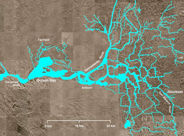
The Sacramento-San Joaquin River Delta of California - covering the right half of the map.
|
||||||||
| Date | |||||||||
| Source | http://en.wikipedia.org/wiki/Image:Wpdms_usgs_photo_sacramento_delta_2.jpg | ||||||||
| Author | Matthew Trump | ||||||||
| Permission ( Reusing this file) |
English Wikipedia user
Decumanus, the copyright holder of this work, hereby publishes it under the following license:
|
||||||||
| Other versions | Derivative works of this file: California Grizzly Bear walking in the Delta Region.jpg |

en:Sacramento-San Joaquin River Delta
File history
Click on a date/time to view the file as it appeared at that time.
| Date/Time | Thumbnail | Dimensions | User | Comment | |
|---|---|---|---|---|---|
| current | 03:21, 8 August 2008 |
| 700 × 520 (81 KB) | Captndelta | {{Information |Description=The Sacramento-San Joaquin River Delta covers the right half of this image. The Sacramento River flows into the delta from the north and the San Joaquin River from the south. The Mokelumne River |
File usage
The following pages on the English Wikipedia use this file (pages on other projects are not listed):
Global file usage
The following other wikis use this file:
- Usage on azb.wikipedia.org
- Usage on de.wikipedia.org
- Usage on es.wikipedia.org
- Usage on eu.wikipedia.org
- Usage on it.wikipedia.org
- Usage on ml.wikipedia.org
- Usage on nl.wikipedia.org
- Usage on uk.wikipedia.org
- Usage on www.wikidata.org