
Size of this JPG preview of this TIF file:
741 × 600 pixels. Other resolutions:
297 × 240 pixels |
593 × 480 pixels |
949 × 768 pixels |
1,265 × 1,024 pixels |
2,530 × 2,048 pixels |
5,000 × 4,048 pixels.
Original file (5,000 × 4,048 pixels, file size: 19.31 MB, MIME type: image/tiff)
| This is a file from the
Wikimedia Commons. Information from its
description page there is shown below. Commons is a freely licensed media file repository. You can help. |
Summary
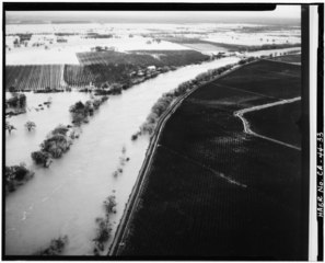
| VIEW TO SOUTHEAST. AERIAL VIEW OF AREA DURING FLOOD STAGE. GIANELLA BRIDGE AT UPPER RIGHT Photographer unknown, January 24, 1970 - Gianella Bridge, Spanning Sacramento River at State Highway 32, Hamilton City, Glenn County, CA | ||||
|---|---|---|---|---|
| Title |
VIEW TO SOUTHEAST. AERIAL VIEW OF AREA DURING FLOOD STAGE. GIANELLA BRIDGE AT UPPER RIGHT Photographer unknown, January 24, 1970 - Gianella Bridge, Spanning Sacramento River at State Highway 32, Hamilton City, Glenn County, CA |
|||
| Depicted place | California; Glenn County; Hamilton City | |||
| Date | Taken on 24 January 1970 | |||
| Dimensions | 4 x 5 in. | |||
| Current location |
Library of Congress Prints and Photographs Division Washington, D.C. 20540 USA
http://hdl.loc.gov/loc.pnp/pp.print |
|||
| Accession number |
HAER CAL,11-HAMCI.V,1-33 |
|||
| Credit line |
|
|||
| Source | https://www.loc.gov/pictures/item/ca1372.photos.011081p | |||
| Permission ( Reusing this file) |
|
|||

| Camera location |
| View this and other nearby images on: OpenStreetMap |
|
|---|
File history
Click on a date/time to view the file as it appeared at that time.
| Date/Time | Thumbnail | Dimensions | User | Comment | |
|---|---|---|---|---|---|
| current | 02:47, 3 July 2014 |
 | 5,000 × 4,048 (19.31 MB) | Fæ | GWToolset: Creating mediafile for Fæ. HABS batch upload 2 July 2014 (301:400) |
File usage
The following pages on the English Wikipedia use this file (pages on other projects are not listed):
Global file usage
The following other wikis use this file:
- Usage on ar.wikipedia.org
- Usage on ca.wikipedia.org