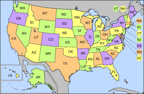
US_state_abbrev_map.png (501 × 327 pixels, file size: 31 KB, MIME type: image/png)
File history
Click on a date/time to view the file as it appeared at that time.
| Date/Time | Thumbnail | Dimensions | User | Comment | |
|---|---|---|---|---|---|
| current | 17:31, 24 September 2014 |
 | 501 × 327 (31 KB) | Robin van der Vliet | Lossless compression |
| 03:24, 5 May 2005 |
 | 501 × 327 (32 KB) | Mattes | new |
File usage
The following pages on the English Wikipedia use this file (pages on other projects are not listed):
- List of American military installations
- List of U.S. state and territory abbreviations
- Lists of restaurants
- User:Fadookie
- User:Fadookie/Userbox
- User:Iketsi/sandbox/disc golf
- User:Northamerica1000/Notepad
- User:Visviva/Map
- Category:American people by state or territory
- Category:Architecture in the United States by state
- Category:COVID-19 pandemic in the United States by state
- Category:Categories by state or territory of the United States
- Category:Communications in the United States by state or territory
- Category:Films set in the United States by state
- Category:Health in the United States by state
- Category:Lists of African-American newspapers
- Category:Lists of newspapers published in the United States by state
- Category:Mass media in the United States by state or territory
- Category:Newspapers published in the United States by state
- Category:Radio stations in the United States by state
- Category:Restaurants in the United States by state or territory
- Category:State governments of the United States
- Category:States of the United States
- Category:Television stations in the United States by state
Global file usage
The following other wikis use this file:
- Usage on ar.wikinews.org
- Usage on azb.wikipedia.org
- Usage on bh.wikipedia.org
- Usage on bn.wikipedia.org
- Usage on bs.wikipedia.org
- Kategorija:Gradovi u Sjedinjenim Američkim Državama
- Kategorija:Okruzi u Sjedinjenim Američkim Državama po saveznim državama
- Kategorija:Glavni gradovi okruga u Sjedinjenim Američkim Državama
- Kategorija:Američka kultura po saveznim državama
- Kategorija:Američki mediji po saveznim državama
- Kategorija:Košarka u Sjedinjenim Američkim Državama po saveznim državama
- Kategorija:Sport u Sjedinjenim Američkim Državama po saveznim državama
- Usage on ca.wikipedia.org
- Usage on cs.wikipedia.org
- Usage on da.wikipedia.org
- Usage on de.wikipedia.org
- Usage on el.wikipedia.org
- Usage on eo.wikipedia.org
- Usage on fa.wikipedia.org
- Usage on fr.wikipedia.org
- Utilisateur:Rinaldum/Images
- Modèle:Carte des États des États-Unis
- Aide:Carte complétée
- Catégorie:Série télévisée se déroulant aux États-Unis
- Modèle:Carte avec lien vers catégories de films dont l'action se déroule aux États-Unis
- Catégorie:Film se déroulant aux États-Unis
- Catégorie:Film tourné aux États-Unis par État
- Catégorie:Film se déroulant aux États-Unis par État
- Usage on fr.wikinews.org
- Usage on gl.wikipedia.org
- Usage on gv.wikipedia.org
- Usage on hu.wikipedia.org
- Usage on id.wikipedia.org
- Daftar singkatan negara bagian Amerika Serikat
- Kategori:Surat kabar Amerika Serikat menurut negara bagian
- Kategori:Media massa Amerika Serikat menurut negara bagian
- Kategori:Komunikasi di Amerika Serikat menurut negara bagian
- Kategori:Daftar surat kabar di Amerika Serikat menurut negara bagian
- Kategori:Stasiun radio Amerika Serikat menurut negara bagian
- Kategori:Pemerintah negara bagian Amerika Serikat
- Kategori:Stasiun televisi Amerika Serikat menurut negara bagian
- Usage on ilo.wikipedia.org
- Usage on ja.wikipedia.org
- Usage on ko.wikipedia.org
- Usage on ku.wikipedia.org
View more global usage of this file.

