
Size of this PNG preview of this SVG file:
620 × 402 pixels. Other resolutions:
320 × 207 pixels |
640 × 415 pixels |
1,024 × 664 pixels |
1,280 × 830 pixels |
2,560 × 1,660 pixels.
Original file (SVG file, nominally 620 × 402 pixels, file size: 768 KB)
| This is a file from the
Wikimedia Commons. Information from its
description page there is shown below. Commons is a freely licensed media file repository. You can help. |
Summary
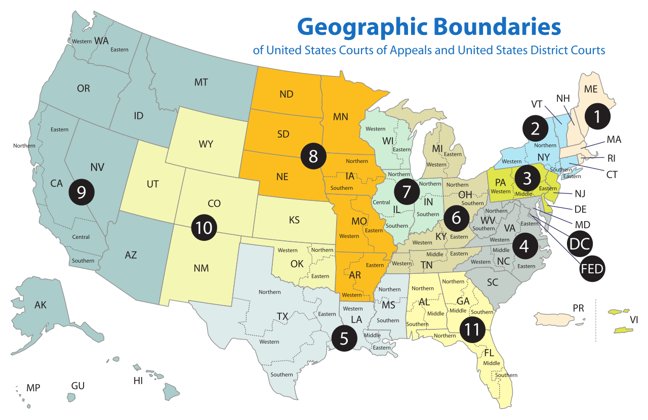
| Description | Map of the geographic boundaries of the various United States courts of appeals and United States district courts. |
| Date | |
| Source | http://www.uscourts.gov/uscourts/images/CircuitMap.pdf |
| Author | PDF by the US Government, converted using Texterity's FreeSVG, tweaked using en:Inkscape by Tintazul |
| Other versions |
|


Licensing
This work is licensed by the creator under the following conditions:
This file is licensed under the
Creative Commons
Attribution-Share Alike 2.5 Generic license.
- You are free:
- to share – to copy, distribute and transmit the work
- to remix – to adapt the work
- Under the following conditions:
- attribution – You must give appropriate credit, provide a link to the license, and indicate if changes were made. You may do so in any reasonable manner, but not in any way that suggests the licensor endorses you or your use.
- share alike – If you remix, transform, or build upon the material, you must distribute your contributions under the same or compatible license as the original.
The original work from which this is derived is in the public domain for the following reason:
This image is a work of a
United States Department of Justice employee, taken or made as part of that person's official duties. As a
work of the U.S. federal government, the image is in the
public domain (17 U.S.C. § 101 and 105).
|
 |
File history
Click on a date/time to view the file as it appeared at that time.
| Date/Time | Thumbnail | Dimensions | User | Comment | |
|---|---|---|---|---|---|
| current | 18:58, 17 April 2018 |
| 620 × 402 (768 KB) | BenbowInn | DC and FED are circuits too, added black circles to emphasize them, also converted to plain SVG |
| 07:48, 11 July 2006 |
 | 620 × 402 (1.14 MB) | Tintazul | {{Tintazul |Description=Map of the geographic boundaries of the various United States Courts of Appeals and United States District Courts. |Source=[http://www.uscourts.gov/image |
File usage
More than 100 pages use this file. The following list shows the first 100 pages that use this file only. A full list is available.
- Case citation
- Circuit court
- Coram nobis
- District Court for the Northern Mariana Islands
- Federal jurisdiction (United States)
- George W. Bush Supreme Court candidates
- Judicial appointment history for United States federal courts
- List of United States courts of appeals cases
- List of former United States district courts
- List of regions of the United States
- United States Attorney
- United States Attorney for the District of Hawaii
- United States Attorney for the Middle District of Florida
- United States Attorney for the Northern District of Indiana
- United States Court of Appeals for the District of Columbia Circuit
- United States Court of Appeals for the Eighth Circuit
- United States Court of Appeals for the Eleventh Circuit
- United States Court of Appeals for the Federal Circuit
- United States Court of Appeals for the Fifth Circuit
- United States Court of Appeals for the First Circuit
- United States Court of Appeals for the Fourth Circuit
- United States Court of Appeals for the Ninth Circuit
- United States Court of Appeals for the Second Circuit
- United States Court of Appeals for the Seventh Circuit
- United States Court of Appeals for the Sixth Circuit
- United States Court of Appeals for the Tenth Circuit
- United States Court of Appeals for the Third Circuit
- United States District Court for the Central District of California
- United States District Court for the Central District of Illinois
- United States District Court for the District of Alaska
- United States District Court for the District of Arizona
- United States District Court for the District of Colorado
- United States District Court for the District of Columbia
- United States District Court for the District of Connecticut
- United States District Court for the District of Delaware
- United States District Court for the District of Hawaii
- United States District Court for the District of Kansas
- United States District Court for the District of Maine
- United States District Court for the District of Maryland
- United States District Court for the District of Massachusetts
- United States District Court for the District of Minnesota
- United States District Court for the District of Montana
- United States District Court for the District of Nebraska
- United States District Court for the District of Nevada
- United States District Court for the District of New Hampshire
- United States District Court for the District of New Jersey
- United States District Court for the District of Oregon
- United States District Court for the District of Puerto Rico
- United States District Court for the District of Rhode Island
- United States District Court for the District of South Carolina
- United States District Court for the District of South Dakota
- United States District Court for the District of Utah
- United States District Court for the District of Vermont
- United States District Court for the District of Wyoming
- United States District Court for the Eastern District of California
- United States District Court for the Eastern District of Louisiana
- United States District Court for the Eastern District of Michigan
- United States District Court for the Eastern District of New York
- United States District Court for the Eastern District of North Carolina
- United States District Court for the Eastern District of Oklahoma
- United States District Court for the Eastern District of Pennsylvania
- United States District Court for the Eastern District of Texas
- United States District Court for the Eastern District of Virginia
- United States District Court for the Eastern District of Washington
- United States District Court for the Eastern District of Wisconsin
- United States District Court for the Middle District of Alabama
- United States District Court for the Middle District of Florida
- United States District Court for the Middle District of Georgia
- United States District Court for the Middle District of North Carolina
- United States District Court for the Middle District of Pennsylvania
- United States District Court for the Northern District of Alabama
- United States District Court for the Northern District of California
- United States District Court for the Northern District of Florida
- United States District Court for the Northern District of Georgia
- United States District Court for the Northern District of Illinois
- United States District Court for the Northern District of Indiana
- United States District Court for the Northern District of New York
- United States District Court for the Northern District of Ohio
- United States District Court for the Northern District of Oklahoma
- United States District Court for the Northern District of Texas
- United States District Court for the Southern District of Alabama
- United States District Court for the Southern District of California
- United States District Court for the Southern District of Florida
- United States District Court for the Southern District of Georgia
- United States District Court for the Southern District of Illinois
- United States District Court for the Southern District of Indiana
- United States District Court for the Southern District of New York
- United States District Court for the Southern District of Ohio
- United States District Court for the Southern District of Texas
- United States District Court for the Western District of Michigan
- United States District Court for the Western District of New York
- United States District Court for the Western District of North Carolina
- United States District Court for the Western District of Tennessee
- United States District Court for the Western District of Texas
- United States District Court for the Western District of Virginia
- United States District Court for the Western District of Washington
- United States District Court for the Western District of Wisconsin
- United States courts of appeals
- United States district court
- United States federal judicial district
View more links to this file.
Global file usage
The following other wikis use this file:
- Usage on ar.wikipedia.org
- Usage on bg.wikipedia.org
- Usage on bn.wikipedia.org
- Usage on ca.wikipedia.org
- Usage on cs.wikipedia.org
- Usage on da.wikipedia.org
- Usage on de.wikipedia.org
- Usage on en.wikinews.org
- Usage on es.wikipedia.org
- Usage on fa.wikipedia.org
- دادگاههای استیناف در ایالات متحده آمریکا
- الگو:دادگاه استیناف آمریکا
- دادگاه استیناف حوزه یکم ایالات متحده آمریکا
- دادگاه استیناف حوزه دوم ایالات متحده آمریکا
- دادگاه استیناف حوزه سوم ایالات متحده آمریکا
- دادگاه استیناف حوزه چهارم ایالات متحده آمریکا
- دادگاه استیناف حوزه پنجم ایالات متحده آمریکا
- دادگاه استیناف حوزه ششم ایالات متحده آمریکا
- دادگاه استیناف حوزه هفتم ایالات متحده آمریکا
- دادگاه استیناف حوزه هشتم ایالات متحده آمریکا
- دادگاه استیناف حوزه نهم ایالات متحده آمریکا
- دادگاه استیناف حوزه دهم ایالات متحده آمریکا
- دادگاه استیناف حوزه یازدهم ایالات متحده آمریکا
- ناحیه قضایی فدرال ایالات متحده آمریکا
- Usage on fi.wikipedia.org
- Usage on fr.wikipedia.org
- Usage on he.wikipedia.org
- הממשלה הפדרלית של ארצות הברית
- בית המשפט הפדרלי התשיעי לערעורים של ארצות הברית
- בית המשפט הפדרלי לערעורים במחוז קולומביה
- משתמש:אורי פרקש/ערך: הממשלה הפדרלית של ארצות הברית
- בית המשפט הפדרלי העשירי לערעורים של ארצות הברית
- בתי המשפט הפדרליים לערעורים של ארצות הברית
- בית המשפט הפדרלי השלישי לערעורים של ארצות הברית
- בית המשפט הפדרלי החמישי לערעורים של ארצות הברית
- בית המשפט הפדרלי השביעי לערעורים של ארצות הברית
- בית המשפט הפדרלי השני לערעורים של ארצות הברית
View more global usage of this file.